

Cambridgeshire sits at the heart of the East Anglian flatlands, a county shaped by water, sky and centuries of fen drainage. The landscape divides between the wide open fenlands of the north and east, where ancient wetland survives in reserve pockets, and the gentler chalk country of the south, where low hills rise above the plain and river valleys carry the Cam, the Great Ouse and the Nene through meadows and waterside paths that define the county’s character.
These dog friendly walks in Cambridgeshire cover the full range of what the county offers, from ancient fen nature reserve to chalk grassland hills, reservoir perimeter, canal towpath and river meadow. Every walk has been chosen for what it delivers to dogs as much as owners, with water access throughout and terrain that rewards properly rather than just tolerating dogs along for the ride.
Wicken Fen
")
Wicken Fen sits roughly ten miles northeast of Cambridge and is one of the oldest nature reserves in the UK – a surviving fragment of the fenland that once covered much of East Anglia. The National Trust manages the site and the walking extends across Baker’s Fen, Adventurers’ Fen and Burwell Fen, with gravel droves, grass paths and boardwalk threading through open water, reed beds, grazing marsh and fen scrub. The Docky Hut Cafe at the visitor centre is dog friendly for ordering, with picnic benches outside.
Dogs register this landscape immediately as something different. The scent is distinctive – reed, standing water and the faint mineral sharpness of ancient peat – and it carries without interruption across open ground. Waterfowl are present throughout in large numbers, including marsh harriers and bearded tits, and dogs on leads will be constantly alert to bird movement at close range from the path edges. Leads are essential throughout to protect ground-nesting birds and livestock.
- Distance: 8 km (5 miles) circular via Baker’s, Adventurers’ and Burwell Fens
- Difficulty: Easy, flat throughout with some uneven grass paths and seasonal mud
- Parking: National Trust car park, Lode Lane, Wicken, CB7 5XP – pay and display, free for NT members
- Facilities: Docky Hut Cafe (dog friendly for ordering), dog bins, visitor centre shop
- Terrain: Gravel droves, grass paths, boardwalk sections, some seasonal mud
- Best for: Dogs that thrive on waterside scent, bird-rich environments and wide open fen walking on lead
Gog Magog Hills and Wandlebury Country Park
")
Wandlebury Country Park occupies around 60 hectares of the Gog Magog Hills, a low chalk ridge that rises to 75 metres just five miles south of Cambridge. The park contains an Iron Age hillfort at Wandlebury Ring, deciduous woodland, chalk grassland grazed by Highland cattle and eight miles of waymarked trails. The circular route takes in Wandlebury Ring and the open chalk downland of Magog Down to the east, where the ancient Roman Road runs along the ridge.
Dogs that have spent walks on flat fenland will register the chalk hills immediately – the elevation changes the way scent behaves, and the combination of chalk grassland, mixed woodland and livestock creates a layered sensory environment. The woodland floor carries bluebells in spring and dense undergrowth year-round, with deer present in the surrounding area whose scent dogs pick up readily from the paths. The Highland cattle sections require leads, but Magog Down’s open perimeter allows off-lead running across rabbit-rich chalk grassland.
- Distance: 5.3 km (3.3 miles) circular from Wandlebury car park
- Difficulty: Easy to Moderate, gentle chalk hill gradients with some uneven woodland paths
- Parking: Wandlebury Country Park car park, Gog Magog Hills, CB22 3AE – small charge applies
- Facilities: Weekend pop-up cafe at Wandlebury, dog bins, The Square and Compasses pub in Great Shelford
- Terrain: Chalk grassland, mixed deciduous woodland, gravel paths, open downland
- Best for: Dogs that enjoy chalk grassland off-lead running, woodland scent and gentle elevation
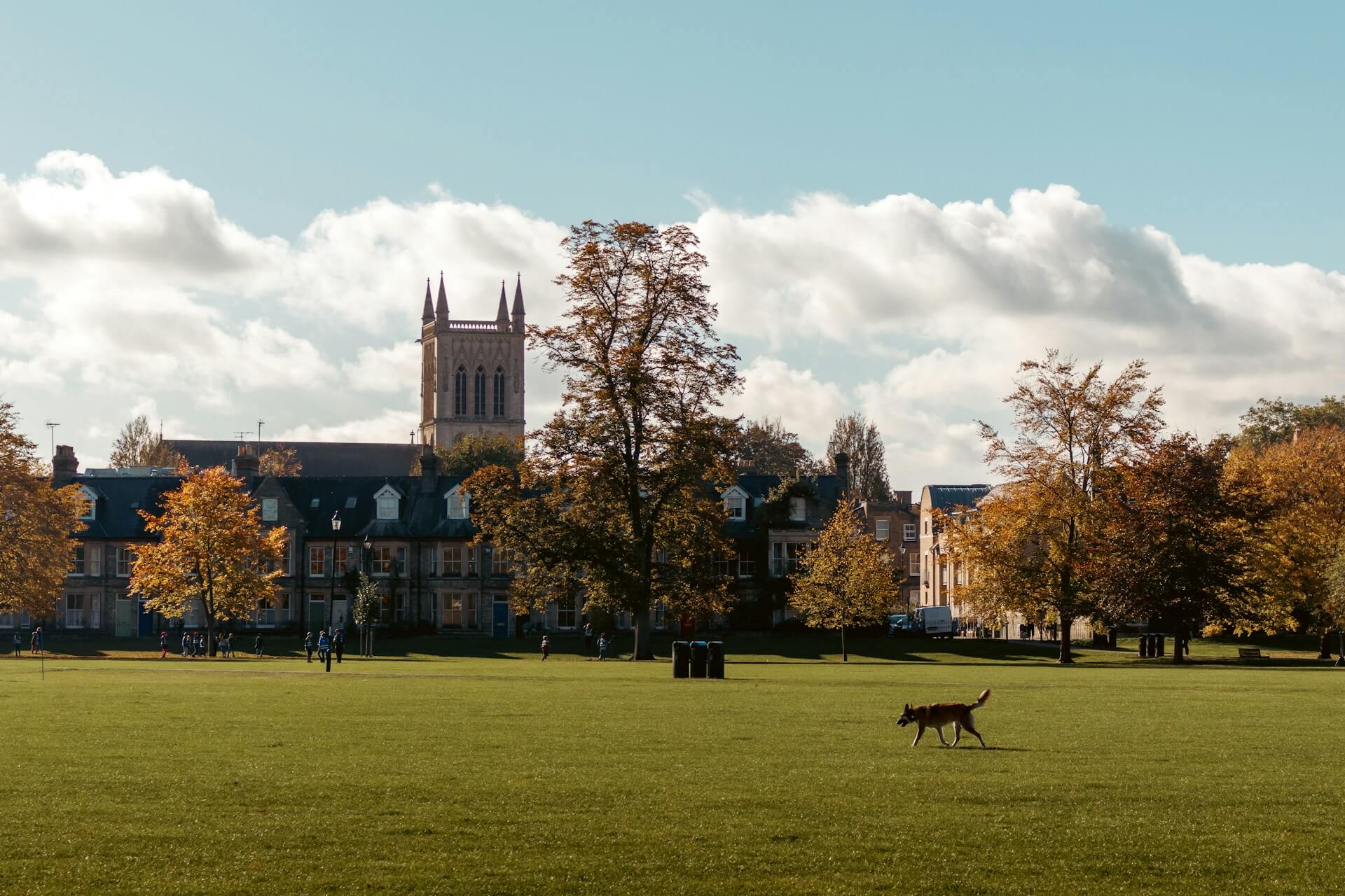
Grantchester Meadows and the River Cam
 (1)")
The walk from Cambridge to Grantchester follows the River Cam south through Coe Fen and across Lammas Land, then along the bank through open water meadows to the village two miles upstream. The meadows are wide and flat, the river runs clear and steady alongside for most of the route, and the flood plain grassland attracts herons, kingfishers and large numbers of waterfowl year-round. The Orchard Tea Garden in Grantchester is dog friendly with outdoor seating.
The River Cam here is a genuine swimming river for dogs – clear water, accessible banks along the meadow section and depth for proper swimming rather than shallow wading. The water meadow grass is grazed short through summer, opening up the scent picture considerably, while the bank carries the smell of freshwater, watercress and riverside vegetation throughout. The return from Grantchester via field paths rather than the riverbank gives variety, and the section through Coe Fen passes livestock requiring leads.
- Distance: 9.7 km (6 miles) circular via riverside path out and field paths back
- Difficulty: Easy, flat on well-maintained grass and gravel paths
- Parking: Lammas Land car park, Newnham, Cambridge, CB3 9EX – pay and display
- Facilities: The Orchard Tea Garden, Grantchester (dog friendly outside), pubs in Grantchester village
- Terrain: River bank grass paths, water meadow, some gravel sections, short road section through Grantchester
- Best for: Water-loving dogs and those that thrive on sustained riverside walking with genuine swimming access
Fen Drayton Lakes
")
Fen Drayton Lakes is an RSPB reserve between Cambridge and St Ives, occupying former gravel workings along the Great Ouse valley now transformed into large lakes, lagoons and connected waterways. The Ferry Lagoon trail covers the largest body of open water in the reserve and takes in the most varied ground – water edges, willow scrub and grassland between the lakes. Two small areas restrict dog access to protect wildlife, at Moore Lake hide and the seasonal Ferry Mere viewpoint.
The lakes are the centrepiece for water-loving dogs, with safe bank access at multiple points and depth for proper swimming in the main lagoon rather than wading at margins. The waterbird population is exceptional – ducks, geese, cormorants and in summer common terns nesting on islands – and dogs will be constantly aware of bird movement on the water and in the reed beds. The smell of open water, willow and aquatic vegetation carries strongly across the reserve throughout.
- Distance: 6.4 km (4 miles) circular via the Ferry Lagoon trail from Harrison’s Drove
- Difficulty: Easy, flat throughout on gravel and grass paths
- Parking: Harrison’s Drove car park, Fen Drayton, CB24 4SA – free
- Facilities: No on-site cafe, nearest facilities in St Ives and Swavesey
- Terrain: Gravel tracks, grass paths, lake edge paths, some seasonal mud
- Best for: Water-loving dogs and those that thrive on bird-rich open waterside environments
Paxton Pits Nature Reserve
")
Paxton Pits sits along the Great Ouse valley near Little Paxton, occupying former gravel workings now transformed into a wetland complex with large lakes and connected river frontage. The circular walk extends beyond the lakes to follow the River Ouse along its bank, pass through grassland to the village of Diddington and return across open pasture. Common terns breed on islands within the reserve in summer, making this one of the most productive birdwatching sites in the county.
The combination of large lakes, river frontage and open pasture gives dogs a varied sensory experience across the circuit. The Great Ouse provides river swimming in the calmer stretches, running faster and cleaner here than in slower lowland sections further south. The tern colony brings concentrated bird activity throughout the breeding season, and the pasture sections require leads near cattle and sheep.
- Distance: 6.4 km (4 miles) circular from Little Paxton car park
- Difficulty: Easy, mostly flat with some gentle field path undulation
- Parking: Paxton Pits car park, Little Paxton, PE19 6ET – free
- Facilities: No on-site cafe, pubs in Little Paxton and St Neots nearby
- Terrain: Gravel reserve paths, river bank grass, open field paths, some mud after rain
- Best for: Dogs that love riverside swimming combined with lake edge walking and open grassland
Wimpole Estate
")
Wimpole Estate is the National Trust’s largest working farm in England, occupying 1,500 acres of Cambridgeshire countryside south of Cambridge near Arrington. The parkland was designed by Lancelot Brown and the walking takes in open parkland with mature specimen trees, the Chinese Bridge over the lake to the Gothic folly and field paths that extend the route to a genuine half-day distance. Dogs are welcome throughout on short leads and the estate cafe is dog friendly outside.
The parkland carries the scent of a working farm throughout – rare breed cattle, sheep and pigs at the Home Farm register immediately from the paths, and deer graze the open ground. The mature oak, ash and lime creates canopy over significant sections, with a woodland floor rich in undergrowth where the estate transitions to more informal ground. Leads are required year-round due to livestock, but the scale of the parkland makes lead walking here feel expansive rather than restrictive.
- Distance: 8 km (5 miles) circular via the parkland perimeter and estate paths
- Difficulty: Easy, mostly flat with some gentle parkland gradients
- Parking: Wimpole Estate main car park, Arrington, SG8 0BW – National Trust pay and display, free for members
- Facilities: Estate cafe (dog friendly outside), farm shop, dog bins throughout
- Terrain: Parkland grass, gravel estate roads, some field paths beyond the formal park
- Best for: Dogs that respond strongly to farm animal scent and enjoy expansive lead walking through historic parkland
Ferry Meadows Country Park, Nene Valley
")
Ferry Meadows covers around 500 acres of meadow, lakes and river frontage along the River Nene west of Peterborough and is one of the largest country parks in the East of England. The lakes – Gunwade and Overton – sit at the heart of a trail network connecting meadow grassland, riverside paths, woodland and the Nene Valley Railway running through the northern edge. The River Nene runs along the southern boundary, making water accessible from almost any point on the circuit.
Dogs that love water will find this walk consistently rewarding – both lakes have accessible banks for swimming and the Nene provides river access along its bank path. The park grassland is rabbit-rich, particularly on the meadow areas away from the main lake paths, and the smell of freshwater and willow carries across the open ground between the lakes. The narrow-gauge steam railway running through the northern section and waterfowl activity on both lakes add movement interest throughout.
- Distance: 8 km (5 miles) circular taking in both lakes and the river bank
- Difficulty: Easy, flat throughout on well-maintained paths
- Parking: Ferry Meadows main car park, Ham Lane, Peterborough, PE2 5UU – pay and display
- Facilities: Lakeside cafe (dog friendly outside), toilets, dog bins throughout
- Terrain: Gravel paths, meadow grass, river bank, some woodland sections
- Best for: Water-loving dogs and those that enjoy large-scale open waterside walking with lake swimming access
Great Fen and the Last of the Meres Trail
")
The Great Fen is one of the most ambitious wetland restoration projects in the UK, reconnecting Woodwalton Fen and Holme Fen across a landscape being actively converted from arable farmland back to wetland. The Last of the Meres is a signed circular walk through the northern part of the project area, passing from newly restored ground at New Decoy Farm through the woodland of Holme Fen and back via the old Holme to Ramsey railway line. The route crosses the former site of Whittlesey Mere, the largest lowland lake in southern England before drainage in 1851.
Dogs experience the Great Fen as a place where scent travels from extraordinary distances – the flat, open restoration ground and persistent breeze mean smells carry from hundreds of metres. The drainage channels hold freshwater accessible at many points, with shallow ditch water for wading throughout. Cattle graze the restoration ground and leads are required in those sections, but Woodwalton Fen itself carries the ancient peat smell of surviving fenland that dogs register differently to modern countryside.
- Distance: 10.5 km (6.5 miles) circular – the Last of the Meres trail from New Decoy car park
- Difficulty: Easy, flat throughout with some rough grass paths and seasonal mud
- Parking: New Decoy Information Point car park, Long Drove, Ramsey Heights, PE26 2RF – free
- Facilities: No on-site cafe, nearest facilities in Ramsey
- Terrain: Gravel tracks, boardwalk, grass restoration paths, drainage channel edges, some seasonal mud
- Best for: Dogs that thrive on wide open fenland, waterway scent and genuine wilderness walking on a significant scale
Ely City Walk and River Great Ouse

Ely sits on what was once an island rising from the surrounding fenland, and the city walk combines riverside paths along the Great Ouse with open country at the edge of the settlement. The route follows the Ouse towpath south past boat moorings to Roswell Pits nature reserve – former clay extraction lakes managed for wildlife – before returning through the city park. Several riverside pubs in Ely are dog friendly, including The Cutter on the waterfront.
The Great Ouse at Ely is a serious swimming river for confident water dogs, with good bank access at the nature reserve end where the ground drops gently to the water. Roswell Pits hold kingfishers, great crested grebes and wintering wildfowl, and dogs will register the lakes and bird activity from the path above. The boat moorings along the early riverside section add movement interest and the open fenland beyond the city edge is visible from the return path.
- Distance: 6.4 km (4 miles) circular from Ely riverside
- Difficulty: Easy, flat throughout on riverside and park paths
- Parking: Ely riverside car parks near the station, CB7 4NT – various pay and display options
- Facilities: The Cutter pub and other riverside pubs (dog friendly), cafes in city centre
- Terrain: Riverside towpath, nature reserve grass paths, city park, some gravel sections
- Best for: Dogs that enjoy riverside walking with swimming access and waterside bird activity
Grafham Water

Grafham Water is a large reservoir in the southwest of Cambridgeshire near the village of Grafham, covering around 640 acres with a signed perimeter path circling the full extent of the water. The western and northern shores pass through mixed woodland managed for wildlife, while the eastern shore is more open with views across the reservoir and sailing boats active through spring and summer. A cafe at the Marlow visitor centre and a second at Harbour View on the southern shore provide natural stops on the circuit.
The reservoir is an important wintering wildfowl site and in autumn the shallower margins attract waders that dogs will register from the path. The woodland sections on the western shore carry the smell of mixed deciduous forest – oak, ash and birch with dense understorey – creating a distinctly different sensory stretch to the open water sections. Wind across the reservoir carries scent from the far shore, and dogs remain alert and engaged throughout a circuit that takes in genuine variety despite the flat terrain.
- Distance: 14 km (8.7 miles) circular perimeter from Marlow car park
- Difficulty: Moderate, mostly flat with some gentle slopes through the northern woodland
- Parking: Marlow car park, Grafham Water, PE28 0BH – pay and display
- Facilities: Visitor centre cafe at Marlow, Harbour View Cafe on the southern shore, The Wheatsheaf pub in Perry
- Terrain: Gravel paths, woodland tracks, open reservoir edge, some field sections
- Best for: Dogs that enjoy sustained lead walking with waterside bird activity, woodland scent and reservoir exposure
Map of Dog Friendly Walks in Cambridgeshire
Use the map below to explore all ten walks. Cambridgeshire’s geography means most routes are spread across flat fenland and river valleys, with the Gog Magog Hills the only real elevation in the south.
Grafham Water is a large reservoir in the southwest of Cambridgeshire near the village of Grafham, covering around 640 acres with a signed perimeter path circling the full extent of the water. The western and northern shores pass through mixed woodland managed for wildlife, while the eastern shore is more open with views across the reservoir and sailing boats active through spring and summer. A cafe at the Marlow visitor centre and a second at Harbour View on the southern shore provide natural stops on the circuit.
The reservoir is an important wintering wildfowl site and in autumn the shallower margins attract waders that dogs will register from the path. The woodland sections on the western shore carry the smell of mixed deciduous forest – oak, ash and birch with dense understorey – creating a distinctly different sensory stretch to the open water sections. Wind across the reservoir carries scent from the far shore, and dogs remain alert and engaged throughout a circuit that takes in genuine variety despite the flat terrain.
- Distance: 14 km (8.7 miles) circular perimeter from Marlow car park
- Difficulty: Moderate, mostly flat with some gentle slopes through the northern woodland
- Parking: Marlow car park, Grafham Water, Grafham, Huntingdon, PE28 0BH – pay and display
- Facilities: Visitor centre cafe at Marlow, Harbour View Cafe on the southern shore, The Wheatsheaf pub in Perry
- Terrain: Gravel paths, woodland tracks, open reservoir edge, some field sections
- Best for: Dogs that enjoy sustained lead walking with waterside bird activity, woodland scent and reservoir exposure
Ely sits on what was once an island rising from the surrounding fenland, and the city walk combines riverside paths along the Great Ouse with open country at the edge of the settlement. The route follows the Ouse towpath south past boat moorings to Roswell Pits nature reserve – former clay extraction lakes managed for wildlife – before returning through the city park. Several riverside pubs in Ely are dog friendly, including The Cutter on the waterfront.
The Great Ouse at Ely is a serious swimming river for confident water dogs, with good bank access at the nature reserve end where the ground drops gently to the water. Roswell Pits hold kingfishers, great crested grebes and wintering wildfowl, and dogs will register the lakes and bird activity from the path above. The boat moorings along the early riverside section add movement interest and the open fenland beyond the city edge is visible from the return path.
- Distance: 6.4 km (4 miles) circular from Ely riverside
- Difficulty: Easy, flat throughout on riverside and park paths
- Parking: Ely riverside car parks near the station, CB7 4NT – various pay and display options
- Facilities: The Cutter pub and other riverside pubs (dog friendly), cafes in city centre
- Terrain: Riverside towpath, nature reserve grass paths, city park, some gravel sections
- Best for: Dogs that enjoy riverside walking with swimming access and waterside bird activity
The Great Fen is one of the most ambitious wetland restoration projects in the UK, reconnecting Woodwalton Fen and Holme Fen across a landscape being actively converted from arable farmland back to wetland. The Last of the Meres is a signed circular walk through the northern part of the project area, passing from newly restored ground at New Decoy Farm through the woodland of Holme Fen and back via the old Holme to Ramsey railway line. The route crosses the former site of Whittlesey Mere, the largest lowland lake in southern England before drainage in 1851.
Dogs experience the Great Fen as a place where scent travels from extraordinary distances – the flat, open restoration ground and persistent breeze mean smells carry from hundreds of metres. The drainage channels hold freshwater accessible at many points, with shallow ditch water for wading throughout. Cattle graze the restoration ground and leads are required in those sections, but Woodwalton Fen itself carries the ancient peat smell of surviving fenland that dogs register differently to modern countryside.
- Distance: 10.5 km (6.5 miles) circular – the Last of the Meres trail from New Decoy car park
- Difficulty: Easy, flat throughout with some rough grass paths and seasonal mud
- Parking: New Decoy Information Point car park, Long Drove, Ramsey Heights, PE26 2RF – free
- Facilities: No on-site cafe, nearest facilities in Ramsey
- Terrain: Gravel tracks, boardwalk, grass restoration paths, drainage channel edges, some seasonal mud
- Best for: Dogs that thrive on wide open fenland, waterway scent and genuine wilderness walking on a significant scale
Ferry Meadows covers around 500 acres of meadow, lakes and river frontage along the River Nene west of Peterborough and is one of the largest country parks in the East of England. The lakes – Gunwade and Overton – sit at the heart of a trail network connecting meadow grassland, riverside paths, woodland and the Nene Valley Railway running through the northern edge. The River Nene runs along the southern boundary, making water accessible from almost any point on the circuit.
Dogs that love water will find this walk consistently rewarding – both lakes have accessible banks for swimming and the Nene provides river access along its bank path. The park grassland is rabbit-rich, particularly on the meadow areas away from the main lake paths, and the smell of freshwater and willow carries across the open ground between the lakes. The narrow-gauge steam railway running through the northern section and waterfowl activity on both lakes add movement interest throughout.
- Distance: 8 km (5 miles) circular taking in both lakes and the river bank
- Difficulty: Easy, flat throughout on well-maintained paths
- Parking: Ferry Meadows main car park, Ham Lane, Orton Waterville, Peterborough, PE2 5UU – pay and display
- Facilities: Lakeside cafe (dog friendly outside), toilets, dog bins throughout
- Terrain: Gravel paths, meadow grass, river bank, some woodland sections
- Best for: Water-loving dogs and those that enjoy large-scale open waterside walking with lake swimming access
Wimpole Estate is the National Trust’s largest working farm in England, occupying 1,500 acres of Cambridgeshire countryside south of Cambridge near Arrington. The parkland was designed by Lancelot Brown and the walking takes in open parkland with mature specimen trees, the Chinese Bridge over the lake to the Gothic folly and field paths that extend the route to a genuine half-day distance. Dogs are welcome throughout on short leads and the estate cafe is dog friendly outside.
The parkland carries the scent of a working farm throughout – rare breed cattle, sheep and pigs at the Home Farm register immediately from the paths, and deer graze the open ground. The mature oak, ash and lime creates canopy over significant sections, with a woodland floor rich in undergrowth where the estate transitions to more informal ground. Leads are required year-round due to livestock, but the scale of the parkland makes lead walking here feel expansive rather than restrictive.
- Distance: 8 km (5 miles) circular via the parkland perimeter and estate paths
- Difficulty: Easy, mostly flat with some gentle parkland gradients
- Parking: Wimpole Estate main car park, Arrington, Royston, SG8 0BW – National Trust pay and display, free for members
- Facilities: Estate cafe (dog friendly outside), farm shop, dog bins throughout
- Terrain: Parkland grass, gravel estate roads, some field paths beyond the formal park
- Best for: Dogs that respond strongly to farm animal scent and enjoy expansive lead walking through historic parkland
Paxton Pits sits along the Great Ouse valley near Little Paxton, occupying former gravel workings now transformed into a wetland complex with large lakes and connected river frontage. The circular walk extends beyond the lakes to follow the River Ouse along its bank, pass through grassland to the village of Diddington and return across open pasture. Common terns breed on islands within the reserve in summer, making this one of the most productive birdwatching sites in the county.
The combination of large lakes, river frontage and open pasture gives dogs a varied sensory experience across the circuit. The Great Ouse provides river swimming in the calmer stretches, running faster and cleaner here than in slower lowland sections further south. The tern colony brings concentrated bird activity throughout the breeding season, and the pasture sections require leads near cattle and sheep.
- Distance: 6.4 km (4 miles) circular from Little Paxton car park
- Difficulty: Easy, mostly flat with some gentle field path undulation
- Parking: Paxton Pits Nature Reserve, High Street, Little Paxton, St Neots, PE19 6ET – free
- Facilities: No on-site cafe, pubs in Little Paxton and St Neots nearby
- Terrain: Gravel reserve paths, river bank grass, open field paths, some mud after rain
- Best for: Dogs that love riverside swimming combined with lake edge walking and open grassland
Fen Drayton Lakes is an RSPB reserve between Cambridge and St Ives, occupying former gravel workings along the Great Ouse valley now transformed into large lakes, lagoons and connected waterways. The Ferry Lagoon trail covers the largest body of open water in the reserve and takes in the most varied ground – water edges, willow scrub and grassland between the lakes. Two small areas restrict dog access to protect wildlife, at Moore Lake hide and the seasonal Ferry Mere viewpoint.
The lakes are the centrepiece for water-loving dogs, with safe bank access at multiple points and depth for proper swimming in the main lagoon rather than wading at margins. The waterbird population is exceptional – ducks, geese, cormorants and in summer common terns nesting on islands – and dogs will be constantly aware of bird movement on the water and in the reed beds. The smell of open water, willow and aquatic vegetation carries strongly across the reserve throughout.
- Distance: 6.4 km (4 miles) circular via the Ferry Lagoon trail from the Holywell Lake car park
- Difficulty: Easy, flat throughout on gravel and grass paths
- Parking: RSPB Fen Drayton Lakes, Holywell Ferry Road, Fen Drayton, CB24 4RB – free
- Facilities: No on-site cafe, nearest facilities in St Ives and Swavesey
- Terrain: Gravel tracks, grass paths, lake edge paths, some seasonal mud
- Best for: Water-loving dogs and those that thrive on bird-rich open waterside environments
The walk from Cambridge to Grantchester follows the River Cam south through Coe Fen and across Lammas Land, then along the bank through open water meadows to the village two miles upstream. The meadows are wide and flat, the river runs clear and steady alongside for most of the route, and the flood plain grassland attracts herons, kingfishers and large numbers of waterfowl year-round. The Orchard Tea Garden in Grantchester is dog friendly with outdoor seating.
The River Cam here is a genuine swimming river for dogs – clear water, accessible banks along the meadow section and depth for proper swimming rather than shallow wading. The water meadow grass is grazed short through summer, opening up the scent picture considerably, while the bank carries the smell of freshwater, watercress and riverside vegetation throughout. The return from Grantchester via field paths rather than the riverbank gives variety, and the section through Coe Fen passes livestock requiring leads.
- Distance: 9.7 km (6 miles) circular via riverside path out and field paths back
- Difficulty: Easy, flat on well-maintained grass and gravel paths
- Parking: Lammas Land car park, Newnham, Cambridge, CB3 9HX – pay and display
- Facilities: The Orchard Tea Garden, Grantchester (dog friendly outside), pubs in Grantchester village
- Terrain: River bank grass paths, water meadow, some gravel sections, short road section through Grantchester
- Best for: Water-loving dogs and those that thrive on sustained riverside walking with genuine swimming access
Wandlebury Country Park occupies around 60 hectares of the Gog Magog Hills, a low chalk ridge that rises to 75 metres just five miles south of Cambridge. The park contains an Iron Age hillfort at Wandlebury Ring, deciduous woodland, chalk grassland grazed by Highland cattle and eight miles of waymarked trails. The circular route takes in Wandlebury Ring and the open chalk downland of Magog Down to the east, where the ancient Roman Road runs along the ridge.
Dogs that have spent walks on flat fenland will register the chalk hills immediately – the elevation changes the way scent behaves, and the combination of chalk grassland, mixed woodland and livestock creates a layered sensory environment. The woodland floor carries bluebells in spring and dense undergrowth year-round, with deer present in the surrounding area whose scent dogs pick up readily from the paths. The Highland cattle sections require leads, but Magog Down’s open perimeter allows off-lead running across rabbit-rich chalk grassland.
- Distance: 5.3 km (3.3 miles) circular from Wandlebury car park
- Difficulty: Easy to Moderate, gentle chalk hill gradients with some uneven woodland paths
- Parking: Wandlebury Country Park car park, Gog Magog Hills, CB22 3AE – small charge applies
- Facilities: Weekend pop-up cafe at Wandlebury, dog bins, The Square and Compasses pub in Great Shelford
- Terrain: Chalk grassland, mixed deciduous woodland, gravel paths, open downland
- Best for: Dogs that enjoy chalk grassland off-lead running, woodland scent and gentle elevation
Wicken Fen sits roughly ten miles northeast of Cambridge and is one of the oldest nature reserves in the UK – a surviving fragment of the fenland that once covered much of East Anglia. The National Trust manages the site and the walking extends across Baker’s Fen, Adventurers’ Fen and Burwell Fen, with gravel droves, grass paths and boardwalk threading through open water, reed beds, grazing marsh and fen scrub. The Docky Hut Cafe at the visitor centre is dog friendly for ordering, with picnic benches outside.
Dogs register this landscape immediately as something different. The scent is distinctive – reed, standing water and the faint mineral sharpness of ancient peat – and it carries without interruption across open ground. Waterfowl are present throughout in large numbers, including marsh harriers and bearded tits, and dogs on leads will be constantly alert to bird movement at close range from the path edges. Leads are essential throughout to protect ground-nesting birds and livestock.
- Distance: 8 km (5 miles) circular via Baker’s, Adventurers’ and Burwell Fens
- Difficulty: Easy, flat throughout with some uneven grass paths and seasonal mud
- Parking: National Trust car park, Lode Lane, Wicken, CB7 5XP – pay and display, free for NT members
- Facilities: Docky Hut Cafe (dog friendly for ordering), dog bins, visitor centre shop
- Terrain: Gravel droves, grass paths, boardwalk sections, some seasonal mud
- Best for: Dogs that thrive on waterside scent, bird-rich environments and wide open fen walking on lead
Explore dog friendly walks across the UK on our Wildpack Map.
Tips for Walking in Cambridgeshire
- The county is predominantly flat – the Gog Magog Hills offer the only real elevation and stand out distinctly for dogs that need height
- Fenland paths flood seasonally between November and March – check trail conditions ahead at Wicken Fen, Fen Drayton and Great Fen
- Ticks present in grassland, reed beds and woodland year-round – check dogs after every walk
- Leads required near livestock on most routes including Wimpole, Great Fen and Grantchester Meadows
- Mosquitoes and horseflies can be significant on fenland walks in summer, particularly at Wicken Fen and Great Fen
- Parking charges apply at National Trust sites – NT membership removes this cost at Wicken Fen and Wimpole
- Grafham Water at 14 km is the longest circuit in the guide – allow a full half-day with stops
What’s Nearby?
- Dog friendly walks in Rutland – Rutland Water reservoir perimeter, rolling countryside and the Welland Valley on the county’s southern edge
- Dog friendly walks in Lincolnshire – Lincolnshire Wolds chalk valleys and beech woodland, the Fens continuing north and coastal salt marsh at the Wash
- Dog friendly walks in Norfolk – Broads waterways and open water, North Norfolk coastal paths and salt marsh, Breckland heathland and ancient forest
- Dog friendly walks in Suffolk – Coastal heathland and river estuaries, ancient Breckland forest continuing west from the county border and the Stour Valley
- Dog friendly walks in Essex – Dedham Vale river meadows, ancient woodland at Epping Forest and the Blackwater and Colne estuaries on the coast
- Dog friendly walks in Hertfordshire – Chilterns beech woodland and chalk grassland summits, the Lea Valley wetland corridor and ancient woodland at Ashridge Estate
- Dog friendly walks in Bedfordshire – Greensand Ridge with proper elevation and mixed woodland, the Great Ouse valley at Bedford and heathland at Sandy
- Dog friendly walks in Northamptonshire – Nene Valley continuation north of Peterborough, Rockingham Forest ancient woodland and reservoir walking at Pitsford Water