

Bedfordshire may not have the dramatic uplands of its neighbours, but it offers a quietly satisfying range of walking country. From the chalk escarpment of the Chilterns in the south, where skylarks rise from short-cropped turf and Iron Age forts crown the ridge, to the wooded spine of the Greensand Ridge running through the county’s heart, and the broad river meadows of the Great Ouse and Ivel in the north and east, it is a county of contrasts and surprises. An unremarkable stretch of farmland can give way abruptly to dense ancient woodland, or a flat canal towpath suddenly commands views across a Georgian market town. The walking here rewards those who take the time to explore.
For dogs, Bedfordshire has a great deal to offer. Much of the county’s woodland and country parkland allows dogs off-lead on well-maintained trails, and the chalk grasslands of the south provide some of the most engaging scent territory in the whole region. The Great Ouse and Grand Union Canal offer excellent flat waterside options, while the Greensand Ridge gives access to miles of woodland and sandy heath. Whichever part of the county you are starting from, there is almost certainly a memorable walk within easy reach.
Dunstable Downs and the Chilterns Gateway
 (1)")
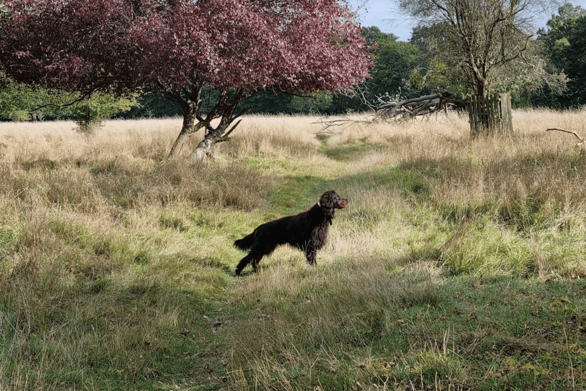
Dunstable Downs is one of the finest chalk grassland walks in the east of England and the most dramatic landscape Bedfordshire has to offer. The walk from the National Trust’s Chilterns Gateway Centre takes you across open downland at over 240 metres, with views stretching across the Vale of Aylesbury and into five counties. The route passes the Five Knolls Neolithic burial mounds, the site of a medieval rabbit warren on Pascombe Hill, and the edge of the London Gliding Club’s airfield at the foot of the escarpment. A circular route of around 5.8 km (3.6 miles) takes in the main ridge before dropping towards Totternhoe and looping back along the ancient Icknield Way.
For dogs, the Downs are outstanding scent country. The short, sweet mineral smell of well-drained chalk turf carries notes of wild thyme and rabbit, and most dogs find it genuinely absorbing. Terrain underfoot is close-cropped grassland and firm chalk paths, dry even in wetter months. There is a dedicated exclusion zone to protect ground-nesting skylarks between March and July, and leads are required around the visitor centre, car park, and near livestock, as sheep graze the lower slopes and must be given plenty of space. Away from these zones, the open grassland allows real freedom, and there is a stream at the foot of the hill for dogs that need a drink on the way back.
- Distance: 5.8 km (3.6 miles)
- Difficulty: Moderate
- Parking: National Trust car park off. £3.50 per day (free for NT members)
- Facilities: Café and toilets at Chilterns Gateway Centre
- Terrain: Short chalk turf and firm paths; can be slippery on steeper sections after rain
- Best for: Dogs that love open scent-rich grassland; owners wanting big views
Sharpenhoe Clappers and the Smithcombe Hills
")
Sharpenhoe Clappers is a National Trust chalk promontory in Bedfordshire’s northern Chilterns, topped with a distinctive clump of ancient beech trees and the earthworks of an Iron Age hill fort. The circular walk of around 7.2 km (4.5 miles) starts from the free NT car park on Sharpenhoe Road near Streatley and follows the Icknield Way and John Bunyan Trail through the Smithcombe Valley before ascending to the ridge. At the top, views open across the Bedfordshire plain towards Bedford, with the Barton Hills to the east and Sundon Hills to the west. The descent from the Clappers into Sharpenhoe village involves a steep set of wooden steps, worth noting for dogs that find steep ground tricky.
Dogs will find the beech woodland at the summit genuinely engaging. The leaf mould and chalk beneath the trees carries the damp, complex smell of decades of accumulated mast and root matter, quite distinct from the open turf below. The terrain moves from firm chalk grassland paths to woodland trails and field-edge sections, and there are no water sources on the upper route, so bring enough for your dog on a warm day. Leads are needed across the whole site where sheep graze the flanks of the Clappers, and the National Trust asks for close control of dogs throughout.
- Distance: 7.2 km (4.5 miles)
- Difficulty: Moderate
- Parking: Free National Trust car park, Sharpenhoe Road, Streatley, MK45 4SH (height barrier: 6’6″)
- Facilities: None on route; The Chequers pub at the Streatley end of Sharpenhoe Road
- Terrain: Chalk grassland, beech woodland, field paths; steep wooden steps on descent
- Best for: Confident walkers and dogs; those who enjoy dramatic chalk ridge landscapes
Ampthill Park and Houghton House
")
Ampthill Park is one of Bedfordshire’s best all-round dog walking spots: a Capability Brown-designed landscape on the Greensand Ridge with sweeping views across the Bedfordshire plain, veteran trees, a reservoir lake, and the intriguing memorial of Katherine’s Cross, marking the site where Catherine of Aragon was held under house arrest in 1533. The walk of around 6.4 km (4.0 miles) links the park with the ruins of Houghton House to the north, a 17th-century mansion said to have inspired the House Beautiful in John Bunyan’s Pilgrim’s Progress. The route follows the Greensand Ridge Walk through the park and the John Bunyan Trail out to the ruins, which stand on a windy hillside with panoramic views across open Bedfordshire.
Dogs are welcome off-lead through most of the park, though leads are needed around the café and car park. The terrain moves from open Greensand parkland, sandy and well-drained underfoot even in winter, through light woodland and then open field paths to Houghton House. Dogs often spend a great deal of time investigating the rabbit warrens along the ridge, and the path back to Ampthill carries the warm, resinous smell of pine and bracken in summer. Some of the return field paths cross arable land where cattle may be present, so keep leads to hand for those sections.
- Distance: 6.4 km (4.0 miles)
- Difficulty: Moderate
- Parking: Ampthill Park car park, Woburn Street, Ampthill, MK45 2HX. Small charge applies
- Facilities: Café at Ampthill Hub in the park; no facilities at Houghton House
- Terrain: Greensand ridge paths, parkland and field edges; some muddy sections in wet weather
- Best for: Dogs that enjoy off-lead parkland; history-minded owners
Maulden Wood
")
Maulden Wood is one of the largest remaining areas of ancient woodland in Bedfordshire, a Forestry England site on the Greensand Ridge between Ampthill and Clophill. The woodland is a mix of semi-natural broadleaf trees, oak, birch and field maple, with patches of acid grassland and older conifer plantation, all threaded through with miles of trails including the long-distance Greensand Ridge Walk. A good circular route of around 7.6 km (4.7 miles) takes in the main woodland block, crosses into the adjacent Pennyfather’s Woods to the south, and returns through more open countryside with views over the clay vale. The paths are largely unmarked beyond the Greensand Ridge route, which adds to the sense of genuine exploration.
This is excellent dog country in all seasons. The woodland interior carries the rich, layered smell of old-growth tree bark, fungal matter, and seasonal bluebells in spring; in autumn the leaf drift adds a deep earthiness that dogs find compelling. Terrain underfoot is sandy Greensand, well-drained but with exposed roots on some paths, and areas that can become genuinely boggy in winter after sustained rain. Dogs can be off-lead through most of the wood, but leads are needed where livestock are present on the southern grassland sections. There are no formal facilities on site, but the Stone Jug pub in nearby Clophill is dog friendly and worth the short drive after a muddy winter walk.
- Distance: 7.6 km (4.7 miles)
- Difficulty: Easy to Moderate
- Parking: Car park off the A6, Maulden, MK45 2AP. Pay on entrance; some local roadside parking also available
- Facilities: None on site; Stone Jug pub in Clophill (MK45 4BY) nearby
- Terrain: Sandy woodland paths and grassland; roots underfoot; boggy in wet weather
- Best for: Dogs that love off-lead woodland; explorers who enjoy finding their own route
Priory Country Park, Bedford
")
Priory Country Park is a 360-acre green space on the eastern edge of Bedford, taking in lakes, meadows, reed beds and a stretch of the River Great Ouse. The park is managed by Bedford Borough Council and holds a Green Flag Award. A circuit of the main lake takes around 25 to 30 minutes, but the full network of trails, extending east towards Cardington and the Danish Camp, gives a comfortable 6.6 km (4.1 miles) of varied waterside walking. The park also connects to Fenlake Meadows nature reserve across the river, adding further options for longer outings. A bird hide overlooks part of the lake, and the Cardington Airship Sheds are visible on the eastern horizon.
Dogs enjoy the park’s variety enormously. The lakeside path carries the rich smell of reed bed and waterfowl, and there are several spots where dogs can enter the water safely. The main paths are firm and well-surfaced, suitable year-round for dogs that don’t like muddy terrain. Be aware that blue-green algae can occasionally affect the lake in warm summer weather, at which point swimming is not safe for dogs. The park is a popular place and can be busy at weekends, so leads are sensible around the visitor centre and car park areas. Fishing is active in parts of the park, so watch for discarded hooks near the water’s edge.
- Distance: 6.6 km (4.1 miles)
- Difficulty: Easy
- Parking: Free car park at Barkers Lane, Bedford, MK41 9DJ
- Facilities: Cloverdale Retreat café at the visitor centre; toilets on site
- Terrain: Surfaced paths and grassy meadow; largely flat throughout
- Best for: Older dogs and less mobile owners; dogs that love water and waterfowl scent
Marston Vale Millennium Country Park
")
The Millennium Country Park sits at the heart of the Forest of Marston Vale, a 61-square-mile community forest project that has transformed former brickworks and clay pits in the vale between Bedford and Milton Keynes. From the Forest Centre at Marston Moretaine, 8 km (5.0 miles) of surfaced, level tracks circle Stewartby Lake and connect a network of woodlands, grasslands and wetland habitats. The Wetlands Nature Reserve at the Pillinge has three bird hides overlooking reedbeds and open water, and the walk passes the still-standing chimneys of the old Stewartby brickworks, giving the landscape a distinctive and unusual industrial character unlike anything else in the county.
This is an ideal walk for dogs that need steady, predictable terrain with reliable water access and no concerns about livestock. The surfaced tracks are wide and well-maintained throughout, and Stewartby Lake is accessible at several points for dogs that enjoy a paddle. The smells here are characteristically fresh and watery, with the mineral tang of lake edge and the heavy sweetness of reed in summer. The park is open 24 hours a day, 365 days a year on foot, making it a dependable option when other sites may be restricted. Dogs must be kept on leads in designated areas around the formal woodland planting zones, where ground-nesting birds are present in spring.
- Distance: 8.0 km (5.0 miles)
- Difficulty: Easy
- Parking: The Forest Centre, Station Road, Marston Moretaine, MK43 0PR. Small charge applies
- Facilities: Lakeside Café at Forest Centre; toilets and shop on site
- Terrain: Surfaced, level tracks throughout; suitable in all weathers
- Best for: Older dogs and those needing flat terrain; water-loving dogs; year-round walking
Grand Union Canal, Leighton Buzzard
")
The Grand Union Canal towpath at Leighton Buzzard offers some of the most accessible and consistently enjoyable flat walking in southern Bedfordshire. A linear walk north from Leighton Lock along the recently resurfaced towpath, returning via Rushmere Country Park and the River Ouzel, gives a comfortable 9.6 km (6.0 miles) of varied waterside and woodland walking. The route passes through Linslade and into the quieter northern sections of the canal before crossing to Rushmere, where there are woodland trails and a series of pretty ponds set among mature trees. The return follows the Ouzel valley back into town. The towpath itself was significantly upgraded in 2022 and is now wide and all-weather for the key sections.
Canal towpath walking is reliably good for dogs: the scent of slow water, marginal vegetation and towpath use by a steady stream of visitors and dogs makes for a rich sensory environment without the stress of complex navigation. The water is accessible at many points along the route, and the Ouzel section has several sandy margins where dogs can enter safely. The towpath is shared with cyclists and anglers, so leads are sensible when passing through busy sections near the town. There is no livestock to worry about on this route, making it a relaxed option for dogs that find farm animals stressful.
- Distance: 9.6 km (6.0 miles)
- Difficulty: Easy
- Parking: Leighton Buzzard town centre car parks, or roadside near the canal on Leighton Road, LU7 1HR
- Facilities: Cafés and pubs in Leighton Buzzard town centre; Grove Lock pub nearby
- Terrain: Resurfaced towpath and woodland paths; flat throughout
- Best for: Dogs that enjoy water access; easy all-year-round walking; less mobile owners
Barton Hills National Nature Reserve
 (1)")
Barton Hills is a nationally important chalk grassland nature reserve in the northern Chilterns, tucked into a series of dry valleys near the village of Barton-le-Clay. The walk from Church Lane takes you up through the valley floor and onto the surrounding ridge, with Deacon Hill to the north offering one of the finest viewpoints in Bedfordshire, looking back across the county towards Bedford and the Greensand Ridge. The circular route of around 5.3 km (3.3 miles) crosses classic chalk downland, with orchids, harebells and cowslips in season and a population of chalk-loving butterflies including chalkhill blue and marbled white. Barton Hills sits alongside Sharpenhoe Clappers as part of the Chilterns AONB and is managed as a National Nature Reserve.
For dogs, the chalk turf here is some of the finest scent terrain in the county, carrying the dry, clean smell of short-grazed limestone grassland with rabbit, hare and seasonal wildflower notes throughout. The terrain is firm and well-drained, with some steeper sections up onto the ridge but nothing technically difficult. Sheep graze the reserve to maintain the chalk flora, and dogs must be kept on leads whenever livestock are present, which is common across the upper slopes. The reserve has no facilities, but Church Lane in Barton-le-Clay has roadside parking and the village has a handful of pubs a short walk away.
- Distance: 5.3 km (3.3 miles)
- Difficulty: Moderate
- Parking: Roadside parking on Church Lane, Barton-le-Clay, MK45 4NR
- Facilities: None on site; pubs in Barton-le-Clay village
- Terrain: Chalk grassland and valley paths; firm underfoot; some steeper ridge sections
- Best for: Dogs and owners who love chalk downland; wildlife-watching walkers
RSPB The Lodge, Sandy
")
The Lodge is the UK headquarters of the RSPB and sits on the Greensand Ridge above Sandy, managing over 220 hectares of woodland, acid grassland and heathland, the largest stretch of heathland in Bedfordshire. The reserve has several well-marked trails totalling around 8 km (5.0 miles), leading through oak and birch woodland, past an Iron Age hillfort on Galley Hill with commanding views over the Ivel valley, and out onto the restored heathland where breeding hobbies and nightjars can be heard in summer. The formal gardens around the Victorian Swiss Cottage are also open to explore, and the café and shop make this a comfortable full-day outing. Dogs are welcome on the Skylark Trail bridleway on a lead.
The heathland and acid woodland terrain at the Lodge is particularly engaging for dogs with a strong nose. The dry, sandy Greensand paths hold scent well, and the combination of heather, bracken, oak leaf and open grassland gives a complex, interesting smell quite different from the chalk downland further south. Dogs must be kept on leads at all times on the reserve, as the RSPB manages the site for breeding and wintering birds of conservation concern. The paths do not become muddy thanks to the sandy substrate, making this a reliable all-weather choice. Non-members pay for parking, and the café serves hot food year-round.
- Distance: 8.0 km (5.0 miles)
- Difficulty: Moderate
- Parking: RSPB The Lodge car park, Sandy to Potton Road, Sandy, SG19 2DL. Free for RSPB members; charge for non-members
- Facilities: Café, shop and toilets at the visitor centre
- Terrain: Sandy woodland and heathland paths; firm in all weathers; some stepped sections
- Best for: Dogs and owners who enjoy heathland; wildlife-focused walkers; reliable all-weather walking
Map of Dog Friendly Walks in Bedfordshire
The walks in this guide range from the chalk escarpment of the Chilterns in the south to the waterside paths of the Great Ouse around Bedford and the Greensand heathland near Sandy in the east. Use the map below to compare locations and choose a walk that suits where you’re travelling from.
The Lodge is the UK headquarters of the RSPB and sits on the Greensand Ridge above Sandy, managing over 220 hectares of woodland, acid grassland and heathland, the largest stretch of heathland in Bedfordshire. The reserve’s trails lead through oak and birch woodland, past an Iron Age hillfort on Galley Hill with commanding views over the Ivel valley, and out onto restored heathland where breeding hobbies and nightjars can be heard in summer. The formal gardens around the Victorian Swiss Cottage add a further point of interest, and the café and shop make this a comfortable full-day destination.
The dry, sandy Greensand paths hold scent well year-round, and the combination of heather, bracken, oak leaf and open grassland gives a complex, interesting environment quite different from the chalk downland in the south of the county. Dogs must be kept on leads at all times on the reserve, as the RSPB manages the site for breeding and wintering birds of conservation concern. The sandy substrate means paths do not become muddy, making this a reliable choice whatever the weather.
- Distance: 8.0 km (5.0 miles)
- Difficulty: Moderate
- Parking: RSPB The Lodge car park, Sandy to Potton Road, Sandy, SG19 2DL. Free for RSPB members; charge for non-members
- Facilities: Café, shop and toilets at the visitor centre
- Terrain: Sandy woodland and heathland paths; firm in all weathers; some stepped sections
- Best for: Dogs and owners who enjoy heathland; wildlife-focused walkers; reliable all-weather walking
Barton Hills is a nationally important chalk grassland nature reserve in the northern Chilterns, tucked into a series of dry valleys near the village of Barton-le-Clay. The circular walk climbs from the valley floor onto the surrounding ridge, with Deacon Hill to the north offering one of the finest viewpoints in Bedfordshire, looking back across the county towards the Greensand Ridge and beyond. Orchids, harebells, cowslips and chalkhill blue butterflies make this one of the most botanically and entomologically rich sites in the county, particularly in early summer.
For dogs, the chalk turf carries the dry, clean smell of short-grazed downland with rabbit, hare and wildflower notes, and the terrain is firm and well-drained with some steeper sections up onto the ridge. Sheep graze the reserve to maintain the chalk flora, and leads are required whenever livestock are present, which is common across the upper slopes. The reserve has no facilities on site, but the village of Barton-le-Clay is a short walk away with pubs and a post office.
- Distance: 5.3 km (3.3 miles)
- Difficulty: Moderate
- Parking: Roadside parking on Church Lane, Barton-le-Clay, MK45 4NR
- Facilities: None on site; pubs in Barton-le-Clay village
- Terrain: Chalk grassland and valley paths; firm underfoot; some steeper ridge sections
- Best for: Dogs and owners who love chalk downland; wildlife-watching walkers
The Grand Union Canal towpath at Leighton Buzzard offers some of the most accessible flat walking in southern Bedfordshire, with a recently resurfaced and widened section running north from Leighton Lock through Linslade into quieter countryside. A circular route of around 9.6 km combines the towpath with Rushmere Country Park, where woodland trails and a series of ponds sit among mature trees, before returning along the River Ouzel valley back into town. The towpath was significantly upgraded in 2022 and is now wide and all-weather for the key sections through and north of the town.
Canal walking is reliably good for dogs, with the scent of slow water, marginal vegetation and a steady stream of towpath users making for a rich sensory environment. The water is accessible at many points along the route, with several sandy margins on the Ouzel section where dogs can enter safely. There is no livestock to worry about on this route, making it a relaxed option for dogs that find farm animals stressful.
- Distance: 9.6 km (6.0 miles)
- Difficulty: Easy
- Parking: Leighton Buzzard town centre car parks, or roadside near the canal on Leighton Road, LU7 1HR
- Facilities: Cafés and pubs in Leighton Buzzard town centre; Grove Lock pub nearby
- Terrain: Resurfaced towpath and woodland paths; flat throughout
- Best for: Dogs that enjoy water access; easy all-year-round walking; less mobile owners
The Millennium Country Park sits at the heart of the Forest of Marston Vale, a community forest project that has transformed former brickworks and clay pits in the vale between Bedford and Milton Keynes. From the Forest Centre at Marston Moretaine, 8 km of surfaced, level tracks circle Stewartby Lake and connect a network of woodlands, grasslands and wetland habitats, passing the Wetlands Nature Reserve with its three bird hides and the still-standing chimneys of the old Stewartby brickworks. The park is open on foot 24 hours a day, 365 days a year, making it one of the most dependable walking destinations in the county.
The smells here are characteristically fresh and watery, with the mineral tang of lake edge and the heavy sweetness of reed in summer, and Stewartby Lake is accessible at several points for dogs that enjoy a paddle. The surfaced tracks are wide and well-maintained throughout, making this an excellent option in wet weather when other sites become difficult. Dogs must be kept on leads in designated areas around the formal woodland planting zones, where ground-nesting birds are present in spring.
- Distance: 8.0 km (5.0 miles)
- Difficulty: Easy
- Parking: The Forest Centre, Station Road, Marston Moretaine, MK43 0PR. Small charge applies
- Facilities: Lakeside Café at Forest Centre; toilets and shop on site
- Terrain: Surfaced, level tracks throughout; suitable in all weathers
- Best for: Older dogs and those needing flat terrain; water-loving dogs; year-round walking
Priory Country Park is a 360-acre Green Flag country park on the eastern edge of Bedford, taking in lakes, reed beds, meadows and a stretch of the River Great Ouse. A circuit of the main lake takes around 25 to 30 minutes, but the full network of trails extending east towards Cardington gives a comfortable 6.6 km of varied waterside walking, with a bird hide overlooking part of the lake and the Cardington Airship Sheds visible on the eastern horizon. The park also connects to Fenlake Meadows nature reserve across the river, adding further options for longer outings.
The lakeside paths carry the rich smell of reed bed and waterfowl, and there are several spots where dogs can enter the water safely. The main paths are firm and well-surfaced, making this a reliable year-round option for dogs that don’t enjoy muddy terrain. Be aware that blue-green algae can affect the lake in warm summer weather, at which point swimming is not safe for dogs.
- Distance: 6.6 km (4.1 miles)
- Difficulty: Easy
- Parking: Free car park at Barkers Lane, Bedford, MK41 9DJ
- Facilities: Cloverdale Retreat café at the visitor centre; toilets on site
- Terrain: Surfaced paths and grassy meadow; largely flat throughout
- Best for: Older dogs and less mobile owners; dogs that love water and waterfowl scent
Maulden Wood is one of the largest remaining areas of ancient woodland in Bedfordshire, a Forestry England site on the Greensand Ridge with a mix of semi-natural broadleaf trees, acid grassland and older conifer plantation. Miles of trails run through the site, including the long-distance Greensand Ridge Walk, and a good circular route of around 7.6 km takes in the main woodland block before crossing into the adjacent Pennyfather’s Woods to the south. The paths are largely unmarked beyond the Greensand Ridge route, which adds to the sense of genuine exploration on each visit.
The woodland interior carries the rich, layered smell of old-growth tree bark, fungal matter and seasonal bluebells in spring, with a deep earthiness in autumn that dogs find genuinely compelling. The sandy Greensand substrate drains well and keeps the main paths walkable year-round, though some sections can become boggy after sustained rain. Dogs can be off-lead through most of the wood, with leads needed only where livestock are present on the southern grassland sections.
- Distance: 7.6 km (4.7 miles)
- Difficulty: Easy to Moderate
- Parking: Car park off the A6, Maulden, MK45 2AP. Pay on entrance; some local roadside parking also available
- Facilities: None on site; Stone Jug pub in Clophill (MK45 4BY) nearby
- Terrain: Sandy woodland paths and grassland; roots underfoot; boggy in wet weather
- Best for: Dogs that love off-lead woodland; explorers who enjoy finding their own route
Ampthill Park is a Capability Brown-designed landscape on the Greensand Ridge, with sweeping views across the Bedfordshire plain, veteran trees, a reservoir lake, and the memorial of Katherine’s Cross marking where Catherine of Aragon was held under house arrest in 1533. The walk links the park with the ruins of Houghton House to the north, a 17th-century mansion said to have inspired the House Beautiful in John Bunyan’s Pilgrim’s Progress, following the Greensand Ridge Walk and John Bunyan Trail. The ruins stand on a windy hilltop with panoramic views in all directions and information panels telling the story of the house and its remarkable owners.
Dogs are welcome off-lead through most of the park, with the sandy Greensand substrate keeping paths well-drained even in winter. The ridge path carries the warm, resinous smell of pine and bracken in summer, and the rabbit warrens along the top give dogs plenty to investigate. Some of the return field paths may cross land where cattle are present, so keep leads to hand for those sections.
- Distance: 6.4 km (4.0 miles)
- Difficulty: Moderate
- Parking: Ampthill Park car park, Woburn Street, Ampthill, MK45 2HX. Small charge applies
- Facilities: Café at Ampthill Hub in the park; no facilities at Houghton House
- Terrain: Greensand ridge paths, parkland and field edges; some muddy sections in wet weather
- Best for: Dogs that enjoy off-lead parkland; history-minded owners
Sharpenhoe Clappers is a National Trust chalk promontory in Bedfordshire’s northern Chilterns, topped with a distinctive clump of ancient beech trees and the earthworks of an Iron Age hill fort. The circular walk follows the Icknield Way and John Bunyan Trail through the Smithcombe Valley before ascending to the ridge, where views open across the Bedfordshire plain with the Barton Hills to the east and Sundon Hills to the west. The descent from the Clappers into Sharpenhoe village involves a steep set of wooden steps, worth noting for dogs that find steep ground tricky.
The beech woodland at the summit carries the damp, complex smell of decades of accumulated mast and chalk leaf mould, quite distinct from the open turf below. Leads are required across the whole site as sheep graze the flanks of the Clappers, and the National Trust asks for close control of dogs throughout. There are no water sources on the upper route, so bring enough for your dog on a warm day.
- Distance: 7.2 km (4.5 miles)
- Difficulty: Moderate
- Parking: Free National Trust car park, Sharpenhoe Road, Streatley, MK45 4SH (height barrier: 6’6″)
- Facilities: None on route; The Chequers pub at the Streatley end of Sharpenhoe Road
- Terrain: Chalk grassland, beech woodland, field paths; steep wooden steps on descent
- Best for: Confident walkers and dogs; those who enjoy dramatic chalk ridge landscapes
Dunstable Downs is one of the finest chalk grassland walks in the east of England, sitting at over 240 metres on the Chilterns escarpment with views stretching across the Vale of Aylesbury and into five counties. The circular route from the National Trust’s Chilterns Gateway Centre passes the Five Knolls Neolithic burial mounds, the site of a medieval rabbit warren on Pascombe Hill, and the edge of the London Gliding Club’s airfield at the foot of the escarpment. The ancient Icknield Way forms part of the return leg, adding a sense of deep history to a walk that already has plenty of it.
For dogs, the Downs are outstanding scent country, with the short sweet mineral smell of well-drained chalk turf carrying notes of wild thyme and rabbit across the open grassland. Leads are required near livestock and around the visitor centre, and dogs are asked to be kept out of the ground-nesting skylark zone between March and July. Away from these areas, the open Downs offer real freedom and there is a stream at the foot of the hill for dogs that need a drink on the way back.
- Distance: 5.8 km (3.6 miles)
- Difficulty: Moderate
- Parking: National Trust car park off B4541, LU6 2GY. £3.50 per day, free for NT members
- Facilities: Café and toilets at Chilterns Gateway Centre
- Terrain: Short chalk turf and firm paths; can be slippery on steeper sections after rain
- Best for: Dogs that love open scent-rich grassland; owners wanting big views
Find dog friendly walks all across the UK on our Wildpack Map.
Tips for Walking with Dogs in Bedfordshire
- Chalk grassland and livestock: The chalk walks at Dunstable Downs, Sharpenhoe Clappers and Barton Hills all have sheep grazing on or near the routes for much of the year. Keep dogs on short leads whenever livestock are visible, and be particularly careful between lambing season in spring and early summer.
- Blue-green algae at Priory and Marston Vale: Both Priory Country Park and Marston Vale have lake swimming available for dogs, but blue-green algae can develop in warm, still weather between June and September. Check for warning signs before letting your dog enter the water, as the toxins can be fatal.
- Seasonal nesting restrictions at Dunstable Downs: The National Trust asks dog owners to keep dogs on leads between March and July to protect ground-nesting skylarks. Two clearly marked exclusion zones are signposted on site. Outside these dates and zones, the Downs are largely off-lead friendly.
- The Lodge parking charges: Non-RSPB members pay to park at The Lodge in Sandy. If you visit regularly, an RSPB membership is worth considering, as it covers parking at all reserves nationwide and funds the conservation work that keeps sites like this in good condition.
- Greensand paths in winter: The sandy substrate of the Greensand Ridge means that Maulden Wood, Ampthill Park and The Lodge drain quickly and remain walkable even after heavy rain. If the rest of the county is waterlogged, these are reliably good options.
- Grand Union Canal towpath sharing: The upgraded towpath at Leighton Buzzard is shared with cyclists, so keep dogs on leads or close at heel when passing through busy sections near the town. Quieter sections to the north are more relaxed.
What’s Nearby
Dog Friendly Walks in Hertfordshire — neighbouring county to the south-east with the Chiltern beechwoods of the Ashridge Estate, the Lee Valley and the Grand Union Canal continuing south.
Dog Friendly Walks in Cambridgeshire — to the north and east, offering flat fenland walking, riverside routes along the Cam and Ouse, and the wide skies of the chalk country around Royston.
Dog Friendly Walks in Northamptonshire — to the north-west, with rolling ironstone countryside, reservoir walking at Pitsford and Ravensthorpe, and the Nene Valley waterside paths.
Dog Friendly Walks in Buckinghamshire — to the west and south-west, where the Chilterns AONB continues through beechwood escarpments, the Chess and Misbourne valleys, and the ridgeline above the Vale of Aylesbury.
Dog Friendly Walks in Oxfordshire — further south-west, with the Chiltern ridge walk continuing towards the Thames, the Ridgeway National Trail, and the river meadows of the upper Thames valley.