

Herefordshire is one of England’s least crowded counties, and for dogs and their owners that translates into genuinely unhurried walking. The county sits between the Welsh Marches and the Malvern Hills, drawing in landscapes that shift from deep river valleys and half-timbered market towns to open moorland and ancient drove roads along the border. There is a looseness to Herefordshire that other counties have lost — field gates left open to the next parish, paths that follow rivers for miles without crossing a road, quiet woodlands that see more deer than walkers on a weekday morning.
Dog walking here rewards those who come prepared for genuine countryside rather than managed parkland. Livestock are a constant presence across the county, from the famous Hereford cattle grazing the flood meadows of the Wye to sheep on the higher ridges of the Black Mountains. Leads are part of the kit in Herefordshire, used thoughtfully rather than grudgingly — and the reward for that care is a county where your dog can cover real ground, take in extraordinary scent variety, and swim in some of the finest clean river water in England.
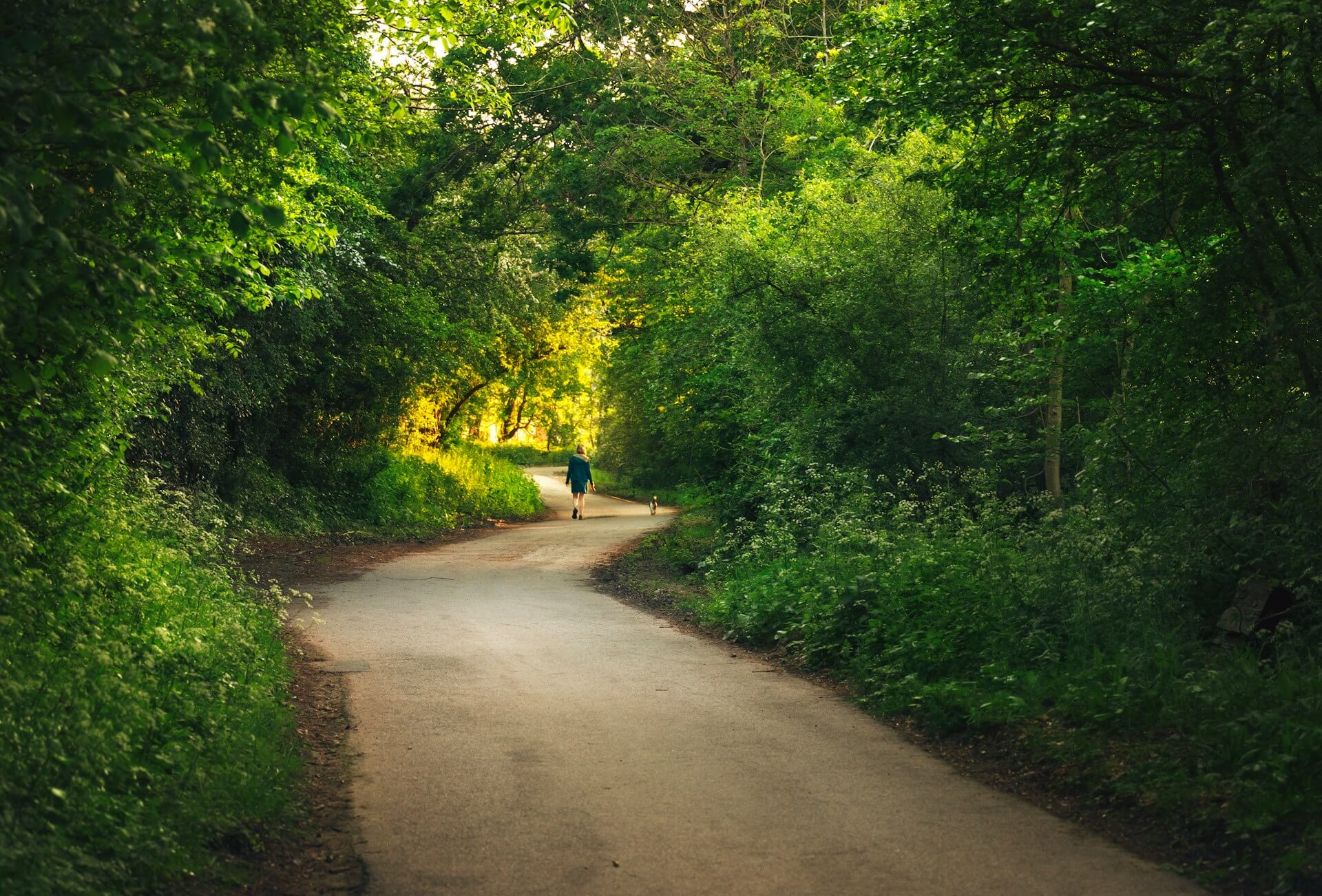
Symonds Yat Rock and the River Wye Loop
_-_geograph.org.uk_-_5103069 (1)")
_-_geograph.org.uk_-_5103069.jpg#P170)
Symonds Yat is Herefordshire’s most dramatic viewpoint, and the walking either side of the famous rock more than lives up to the outlook. The main loop descends from the car park at Symonds Yat Rock through mixed woodland to the riverside, following the Wye upstream through the gorge before climbing back through the trees via the Biblins suspension bridge. The full circuit runs to around 8.5 km (5.3 miles) and takes in some of the most spectacular river scenery in the Welsh Marches. Peregrine falcons nest on the limestone cliffs above the gorge each spring and are often visible from the rock itself.
Dogs find this walk enormously stimulating — the woodland floor is rich with fox, deer, and badger scent, and the descent to the river brings in the cool mineral smell of limestone and wet shale. The Wye at the bottom of the gorge is clean and deep in places, with shingle banks where dogs can wade and drink. Leads are essential near the cliff edge at the rock itself and on any sections of the road crossing, but the woodland paths are quiet enough to allow off-lead walking for dogs with reliable recall. The steep sections of the climb back up are the main physical challenge.
- Distance: 8.5 km (5.3 miles)
- Difficulty: Moderate
- Parking: Forestry England pay and display car park at Symonds Yat Rock, HR9 6JL
- Facilities: Café at the rock, seasonal refreshments near the river crossing
- Terrain: Woodland paths, riverside track, steep sections with loose stone on the ascent
- Best for: Dogs who love water and woodland; confident walkers comfortable with steep ground
Hay Bluff and the Gospel Pass
")
The Gospel Pass is the highest road in Wales, and the open moorland either side of it stretches into Herefordshire along the Black Mountains ridge. The walk from the Hay Bluff car park takes in the summit plateau and the long ridge south toward Lord Hereford’s Knob, covering around 9.2 km (5.7 miles) of unfenced upland. The views from the ridge extend across the Wye Valley, the Brecon Beacons to the south, and on clear days as far as the Shropshire hills. This is genuinely wild walking — no gates, no stiles, just open common land with cropped bilberry and wind-bent grass underfoot.
The scent up here is clean moorland — dry heather, thin acid soil, and the occasional sweet trace of bilberry — very different from the meadow and woodland smells lower in the county. Dogs with energy to burn can range wide on the plateau where it is unfenced common, though the ridge top itself should be walked with care given the steep drop to the east. Sheep graze the common for much of the year and leads are needed whenever livestock are present. The ground is firm in dry summer conditions but becomes wet and tussocky after rain; boots and dogs with short coats may want this reserved for drier days.
- Distance: 9.2 km (5.7 miles)
- Difficulty: Challenging
- Parking: Hay Bluff car park, Hay-on-Wye, HR3 5RU
- Facilities: None on route; cafés and pubs in Hay-on-Wye 3 km away
- Terrain: Open moorland, grassy ridge, boggy in places after rain
- Best for: High-energy dogs and walkers who enjoy wild, exposed ridge walking
The Golden Valley — Dorstone to Arthur’s Stone
")
The Golden Valley follows the River Dore from the hills near Hay down toward Pontrilas, and the stretch around Dorstone is one of the quietest and most beautiful in the county. This circular walk links the village of Dorstone with the Neolithic burial chamber of Arthur’s Stone on the ridge above, taking in meadow paths, a gentle river crossing, and open farmland with long views back across the valley. The full loop is 7.8 km (4.8 miles) and gains around 180 metres on the way up to the ridge. Arthur’s Stone itself is one of the most atmospherically sited prehistoric monuments in England, sitting alone on the hilltop with nothing but grass and sky around it.
The meadow sections along the Dore carry a warm, damp smell of river grass and wild garlic in spring, giving way to the drier mineral scent of open ridge pasture as you climb. The river itself offers a shallow crossing point where dogs can wade and drink, and the farmland paths are quiet enough for off-lead walking in sections where no livestock are present. Cattle graze some of the lower meadows and leads are needed in those fields. The ridge top around Arthur’s Stone is unfenced and dogs can range more freely there.
- Distance: 7.8 km (4.8 miles)
- Difficulty: Moderate
- Parking: Roadside parking in Dorstone village, HR3 6AN
- Facilities: The Pandy Inn in Dorstone for post-walk refreshment
- Terrain: Meadow paths, one river crossing, open pasture ridge — can be muddy in the valley after rain
- Best for: Dogs who enjoy a varied mix of river, meadow, and open hillside
Offa’s Dyke Path — Kington to Hergest Ridge
")
Hergest Ridge rises immediately west of Kington and offers one of the finest easy ridge walks in the Welsh Marches. The route follows the Offa’s Dyke Path from the edge of town up onto the open common, where the ridge stretches for around 5 km of unfenced grassland with views south to the Black Mountains and north toward Shropshire. The full out-and-back from Kington to the trig point and back is 10.4 km (6.5 miles), though the ridge can be shortened by turning around at any point. This is the landscape that inspired Mike Oldfield’s Hergest Ridge album and the open quality of the walking makes that connection feel entirely plausible.
The common is grazed by a famous herd of wild ponies, which adds excitement for dogs and means leads are required whenever ponies are encountered — they can be anywhere on the ridge and the rule should be applied across the whole common when they are visible. The turf is short and springy, underlaid with free-draining soil that stays walkable even after wet weather, and the scent is that distinctive upland grassland mix of dry earth, horse, and wind. No water on the ridge itself — bring enough for your dog on warmer days. A genuinely special walk for those who value open space above almost everything else.
- Distance: 10.4 km (6.5 miles)
- Difficulty: Moderate
- Parking: Kington town car park, HR5 3BQ
- Facilities: Pubs and cafés in Kington; nothing on the ridge
- Terrain: Tarmac lane to start, then firm open grassland — excellent underfoot in most conditions
- Best for: Dogs who need space to move; best avoided with very reactive dogs due to free-roaming ponies
Croft Ambrey and Croft Castle
")
The National Trust’s Croft Castle estate in north Herefordshire contains one of the most complete combinations of ancient woodland, parkland, and Iron Age hilltop in the county. The walk from the estate car park takes in the avenue of ancient Spanish chestnuts, the open deer park, and the climb to Croft Ambrey hillfort — an Iron Age enclosure with sweeping views across to Wales and Shropshire. The main circuit is around 6.5 km (4 miles) and can be extended by following the woodland edge further north. The chestnuts along the drive are estimated to be 350 years old, giving the park an enclosed, cathedral-like quality on the approach.
The woodland floor carries the deep, complex smell of old parkland — centuries of leaf fall, the sweet rot of ancient wood, and the persistent fox and deer scent that runs through Croft year-round. Dogs find the transition from open parkland to woodland particularly engaging. The deer park section requires leads as deer are present, and dogs must remain under close control throughout the estate in line with National Trust guidance. The hilltop fort itself is open and grassy, with good views to reward the climb.
- Distance: 6.5 km (4 miles)
- Difficulty: Moderate
- Parking: National Trust car park at Croft Castle, HR6 9PW (free for NT members)
- Facilities: National Trust café and toilets at the castle
- Terrain: Parkland paths, woodland tracks, grassy hilltop — generally firm
- Best for: Well-managed dogs comfortable in a National Trust deer park setting
Aconbury Hill and the Wye Valley Below
")
Aconbury is a quiet hill south of Hereford, topped by an Iron Age hillfort and cloaked in ancient oak woodland on its flanks. The walk from the village of Aconbury takes a circular route through the woodland, up to the fort ramparts, and back via field paths with views across to the Wye Valley and the Malverns. At 6.1 km (3.8 miles) it is one of the shorter and gentler walks in this list, making it a good choice for a half-day or for owners with older dogs. The hillfort itself sits among woodland that has been barely touched for centuries, giving it a genuinely remote and ancient feel despite being a short drive from the city.
The oak woodland carries a rich, damp smell of moss, bracket fungus, and old bark — the kind of scent environment that keeps a dog’s nose working hard for the whole circuit. Squirrels are present in good numbers, which will occupy the attention of dogs inclined that way. The paths are on the whole dry and firm, though the shaded north-facing slopes can hold mud through winter and into spring. No water access on this route, so a carried supply is worthwhile. Off-lead is possible on the quieter woodland sections for dogs with good recall.
- Distance: 6.1 km (3.8 miles)
- Difficulty: Easy to Moderate
- Parking: Roadside parking in Aconbury village, HR2 8LN
- Facilities: None on route; Hereford city 8 km north
- Terrain: Woodland paths and field edges, can be muddy on north slopes in winter
- Best for: Older dogs and owners wanting a quieter, shorter woodland walk
The Wye at Hereford — The Cathedral and Riverside Path
")
Hereford’s riverside path runs along the Wye from the Victoria Bridge in the west of the city to the Hunderton Bridge downstream, passing below the cathedral and through the Bishop’s Meadow. The full out-and-back along both banks is around 5.8 km (3.6 miles) and is almost entirely flat, making it the most accessible walk in this list. The path is well-maintained and easy to navigate, passing through managed parkland and open meadow with the city skyline and cathedral tower visible throughout. It serves as a useful base for visitors using Hereford as a hub before venturing into the wider county.
The Wye here is wide and slow, carrying a clean, slightly silty smell — very different from the gorge at Symonds Yat. Dogs can access the river at several gravel banks and shingle beaches along the Bishop’s Meadow section, and paddling is popular in summer. The path is shared with cyclists and other users, and the meadow itself can be busy at weekends, so this suits sociable, steady dogs rather than anxious ones. Leads are required through the formal sections near the cathedral grounds.
- Distance: 5.8 km (3.6 miles)
- Difficulty: Easy
- Parking: Hereford city centre car parks; nearest is Edgar Street, HR4 9JR
- Facilities: Full city facilities; public toilets near the cathedral
- Terrain: Tarmac and mown grass paths, completely flat
- Best for: Older dogs, puppies on their first walks, or owners wanting an easy city-based route
Bircher Common and High Vinnalls
")
Bircher Common is a piece of ancient open heathland owned by the National Trust on the edge of the Mortimer Forest north of Ludlow. The walk from the common car park crosses the heathland, dips into the forestry plantation at High Vinnalls, and loops back across the ridge with views across north Herefordshire and into Shropshire. The circuit runs to 7.4 km (4.6 miles) and can be extended by linking with the Mortimer Forest network of tracks. The common itself is one of the few surviving fragments of lowland heath in the Marches, and its open, gorse-covered plateau has a character entirely different from the managed farmland around it.
Gorse in flower gives the common a warm, coconut-sweet smell in spring and early summer, layered over the dry, grassy scent of the heath itself. Dogs can range widely on the open common sections, which are largely free of livestock though occasional cattle do graze here seasonally — check signage on arrival. The forestry tracks are firm and wide, easy underfoot in most conditions. A small seasonal pond on the common edge offers water access for dogs on the return leg. This is a walk that rewards dogs who enjoy variety of terrain and texture.
- Distance: 7.4 km (4.6 miles)
- Difficulty: Moderate
- Parking: Bircher Common National Trust car park, HR6 0AT
- Facilities: None on route; Ludlow 10 km north with full facilities
- Terrain: Heathland tracks, forestry roads, some rooty woodland sections
- Best for: Dogs who enjoy open heath and woodland mix; good in all seasons
Ledbury and the Malvern Hills Fringe
")
Ledbury is one of Herefordshire’s prettiest market towns, and the walking on its eastern edge takes in the first outlying hills of the Malvern chain along with orchard country and hop yard paths that feel entirely specific to this corner of England. The circular route from the town centre heads east through the orchards, climbs to the Herefordshire Beacon viewpoint — a detached outlier of the main Malvern ridge — and returns via quiet lanes and the town’s medieval centre. The full circuit is 8.9 km (5.5 miles) with a moderate climb to the beacon.
The orchard paths in spring and autumn carry one of the most distinctive smells in Herefordshire walking: ripe apple, cider vinegar tang, and the yeasty sweetness of windfall. Dogs find this landscape rich and engaging, and the beacon itself offers a short off-lead stretch on open hillside. The descent returns through farmland where dogs should be on leads due to livestock in most fields. The town’s Church Lane and market centre are cobbled and narrow, best navigated on-lead for the start and finish of the route.
- Distance: 8.9 km (5.5 miles)
- Difficulty: Moderate
- Parking: Ledbury town centre car parks, HR8 1DS
- Facilities: Full town facilities in Ledbury; several dog-friendly pubs
- Terrain: Orchard paths, open hillside, quiet lanes, cobbled town sections
- Best for: Dogs who enjoy rich rural scent variety; owners who want town facilities at the start and end
Goodrich Castle and the River Wye at Ross
")
The walk from Goodrich village to the castle and along the Wye toward Ross-on-Wye combines one of the county’s most dramatic medieval landmarks with the quieter stretch of riverside below the gorge. The route loops from the village car park down to the river, follows the Wye north with the castle visible on its red sandstone bluff above, then climbs to the castle itself before returning through farmland. The full circuit is 9.6 km (6 miles). Goodrich Castle is managed by English Heritage and admission is charged to enter the inner precinct, though the exterior and grounds are freely accessible.
The red sandstone of the bluff gives the soil here a warm, iron-rich smell quite different from the limestone of the gorge upstream. The riverside sections are flat and easy, with the Wye accessible at several gravel beaches for paddling and drinking. The climb to the castle is steep in one short section and the farmland return requires leads as sheep and cattle are grazed in the lower fields. The castle grounds themselves have a compact, grassy outer ward where dogs on leads can explore while you take in the view.
- Distance: 9.6 km (6 miles)
- Difficulty: Moderate
- Parking: Goodrich village car park, HR9 6HY
- Facilities: English Heritage facilities at the castle; the Hostelry at Goodrich for food and drink
- Terrain: Riverside path, farmland, one steep sandstone climb to the castle
- Best for: Dogs who enjoy river access paired with upland variety; great for a full day out
Map of Dog Friendly Walks in Herefordshire
These walks are spread from the Black Mountains border in the west to the Malvern fringe in the east, and from the ridge country around Kington in the north to the Wye gorge at Symonds Yat in the south. The map below gives a sense of the county’s geography and can help you choose a walk based on where you are staying or travelling from.
The walk from Goodrich village to the castle and along the Wye toward Ross-on-Wye combines one of the county’s most dramatic medieval landmarks with quieter riverside walking below the gorge. The route loops from the village car park down to the river, follows the Wye north with the castle visible on its red sandstone bluff above, then climbs to the castle before returning through farmland. The full circuit is 9.6 km (6 miles).
The red sandstone of the bluff gives the soil here a warm, iron-rich smell quite different from the limestone of the gorge upstream. The riverside sections are flat and easy, with the Wye accessible at several gravel beaches for paddling and drinking. The climb to the castle is steep in one short section and the farmland return requires leads as sheep and cattle are grazed in the lower fields.
- Distance: 9.6 km (6 miles)
- Difficulty: Moderate
- Parking: Goodrich village car park, HR9 6HY
- Facilities: English Heritage facilities at the castle; the Hostelry at Goodrich
- Terrain: Riverside path, farmland, one steep sandstone climb
- Best for: Dogs who enjoy river access paired with upland variety; great for a full day out
Ledbury is one of Herefordshire’s prettiest market towns, and the walking on its eastern edge takes in the first outlying hills of the Malvern chain along with orchard country and hop yard paths that feel entirely specific to this corner of England. The circular route heads east through the orchards, climbs to the Herefordshire Beacon viewpoint, and returns via quiet lanes and the town’s medieval centre. The full circuit is 8.9 km (5.5 miles) with a moderate climb to the beacon.
The orchard paths in spring and autumn carry one of the most distinctive smells in Herefordshire walking: ripe apple, cider vinegar tang, and the yeasty sweetness of windfall. Dogs find this landscape rich and engaging, and the beacon itself offers a short off-lead stretch on open hillside. The descent returns through farmland where dogs should be on leads due to livestock in most fields.
- Distance: 8.9 km (5.5 miles)
- Difficulty: Moderate
- Parking: Ledbury town centre car parks, HR8 1DS
- Facilities: Full town facilities; several dog-friendly pubs
- Terrain: Orchard paths, open hillside, quiet lanes, cobbled town sections
- Best for: Dogs who enjoy rich rural scent variety; owners who want town facilities at the start and end
Bircher Common is a piece of ancient open heathland owned by the National Trust on the edge of the Mortimer Forest north of Ludlow. The walk from the common car park crosses the heathland, dips into the forestry plantation at High Vinnalls, and loops back across the ridge with views across north Herefordshire and into Shropshire. The circuit runs to 7.4 km (4.6 miles) and the common itself is one of the few surviving fragments of lowland heath in the Marches.
Gorse in flower gives the common a warm, coconut-sweet smell in spring and early summer, layered over the dry, grassy scent of the heath itself. Dogs can range widely on the open common sections, which are largely free of livestock though occasional cattle do graze here seasonally. The forestry tracks are firm and wide, easy underfoot in most conditions, and a small seasonal pond on the common edge offers water access on the return leg.
- Distance: 7.4 km (4.6 miles)
- Difficulty: Moderate
- Parking: Bircher Common National Trust car park, HR6 0AT
- Facilities: None on route; Ludlow 10 km north
- Terrain: Heathland tracks, forestry roads, some rooty woodland sections
- Best for: Dogs who enjoy open heath and woodland mix; good in all seasons
Hereford’s riverside path runs along the Wye from the Victoria Bridge in the west of the city to the Hunderton Bridge downstream, passing below the cathedral and through the Bishop’s Meadow. The full out-and-back along both banks is around 5.8 km (3.6 miles) and is almost entirely flat, making it the most accessible walk in this list. The path is well-maintained and easy to navigate, with the city skyline and cathedral tower visible throughout.
The Wye here is wide and slow, carrying a clean, slightly silty smell very different from the gorge at Symonds Yat. Dogs can access the river at several gravel banks and shingle beaches along the Bishop’s Meadow section, and paddling is popular in summer. The path is shared with cyclists and other users and the meadow can be busy at weekends, so this suits sociable, steady dogs rather than anxious ones.
- Distance: 5.8 km (3.6 miles)
- Difficulty: Easy
- Parking: Edgar Street car park, Hereford, HR4 9JR
- Facilities: Full city facilities; public toilets near the cathedral
- Terrain: Tarmac and mown grass paths, completely flat
- Best for: Older dogs, puppies on their first walks, or owners wanting an easy city-based route
Aconbury is a quiet hill south of Hereford, topped by an Iron Age hillfort and cloaked in ancient oak woodland on its flanks. The walk from the village takes a circular route through the woodland, up to the fort ramparts, and back via field paths with views across to the Wye Valley and the Malverns. At 6.1 km (3.8 miles) it is one of the shorter and gentler walks in the county, making it a good choice for a half-day or for owners with older dogs.
The oak woodland carries a rich, damp smell of moss, bracket fungus, and old bark — the kind of scent environment that keeps a dog’s nose working hard for the whole circuit. The paths are on the whole dry and firm, though shaded north-facing slopes can hold mud through winter and into spring. Off-lead walking is possible on the quieter woodland sections for dogs with good recall, and squirrels are present in good numbers throughout.
- Distance: 6.1 km (3.8 miles)
- Difficulty: Easy to Moderate
- Parking: Roadside parking, Aconbury village, HR2 8LN
- Facilities: None on route; Hereford city 8 km north
- Terrain: Woodland paths and field edges, can be muddy on north slopes in winter
- Best for: Older dogs and owners wanting a quieter, shorter woodland walk
The National Trust’s Croft Castle estate contains one of the most complete combinations of ancient woodland, parkland, and Iron Age hilltop in the county. The walk from the estate car park takes in the avenue of ancient Spanish chestnuts, the open deer park, and the climb to Croft Ambrey hillfort — an Iron Age enclosure with sweeping views across to Wales and Shropshire. The main circuit is around 6.5 km (4 miles) and the chestnuts along the drive, estimated at 350 years old, give the park a cathedral-like quality on the approach.
The woodland floor carries the deep, complex smell of old parkland — centuries of leaf fall, sweet rot of ancient wood, and the persistent fox and deer scent that runs through Croft year-round. Dogs find the transition from open parkland to woodland particularly engaging. The deer park section requires leads as deer are present, and dogs must remain under close control throughout the estate in line with National Trust guidance.
- Distance: 6.5 km (4 miles)
- Difficulty: Moderate
- Parking: National Trust car park, Croft Castle, HR6 9PW
- Facilities: National Trust café and toilets at the castle
- Terrain: Parkland paths, woodland tracks, grassy hilltop
- Best for: Well-managed dogs comfortable in a National Trust deer park setting
Hergest Ridge rises immediately west of Kington and offers one of the finest easy ridge walks in the Welsh Marches. The route follows the Offa’s Dyke Path from the edge of town up onto the open common, where the ridge stretches for around 5 km of unfenced grassland with views south to the Black Mountains and north toward Shropshire. The full out-and-back to the trig point and back is 10.4 km (6.5 miles), though the ridge can be shortened by turning around at any point.
The common is grazed by a famous herd of wild ponies, which means leads are required whenever ponies are encountered — they can appear anywhere on the ridge. The turf is short and springy, underlaid with free-draining soil that stays walkable even after wet weather, and the scent is that distinctive upland grassland mix of dry earth, horse, and wind. No water on the ridge itself, so carry enough for your dog on warmer days.
- Distance: 10.4 km (6.5 miles)
- Difficulty: Moderate
- Parking: Kington town car park, HR5 3BQ
- Facilities: Pubs and cafés in Kington; nothing on the ridge
- Terrain: Tarmac lane to start, then firm open grassland
- Best for: Dogs who need space to move; best avoided with very reactive dogs due to free-roaming ponies
The Golden Valley follows the River Dore from the hills near Hay down toward Pontrilas, and the stretch around Dorstone is one of the quietest and most beautiful in the county. This circular walk links the village with the Neolithic burial chamber of Arthur’s Stone on the ridge above, taking in meadow paths, a gentle river crossing, and open farmland with long views back across the valley. The full loop is 7.8 km (4.8 miles) with around 180 metres of ascent to the ridge.
The meadow sections along the Dore carry a warm, damp smell of river grass and wild garlic in spring, giving way to the drier mineral scent of open ridge pasture as you climb. The river offers a shallow crossing point where dogs can wade and drink, and the farmland paths are quiet enough for off-lead walking where no livestock are present. Cattle graze some of the lower meadows and leads are needed in those fields.
- Distance: 7.8 km (4.8 miles)
- Difficulty: Moderate
- Parking: Roadside parking, Dorstone village, HR3 6AN
- Facilities: The Pandy Inn, Dorstone
- Terrain: Meadow paths, one river crossing, open pasture ridge — can be muddy after rain
- Best for: Dogs who enjoy a varied mix of river, meadow, and open hillside
The Gospel Pass is the highest road in Wales, and the open moorland either side stretches into Herefordshire along the Black Mountains ridge. The walk from the Hay Bluff car park takes in the summit plateau and the long ridge south toward Lord Hereford’s Knob, covering around 9.2 km (5.7 miles) of unfenced upland. Views extend across the Wye Valley, the Brecon Beacons to the south, and on clear days as far as the Shropshire hills.
The scent up here is clean moorland — dry heather, thin acid soil, and the occasional sweet trace of bilberry — very different from the meadow and woodland smells lower in the county. Dogs with energy to burn can range wide on the plateau where it is unfenced common, though sheep graze here for much of the year and leads are needed whenever livestock are present. The ground is firm in dry conditions but becomes wet and tussocky after rain.
- Distance: 9.2 km (5.7 miles)
- Difficulty: Challenging
- Parking: Hay Bluff car park, HR3 5RU
- Facilities: None on route; cafés and pubs in Hay-on-Wye 3 km away
- Terrain: Open moorland, grassy ridge, boggy in places after rain
- Best for: High-energy dogs and walkers who enjoy wild, exposed ridge walking
Symonds Yat is Herefordshire’s most dramatic viewpoint, and the walking either side of the famous rock more than lives up to the outlook. The main loop descends from the car park through mixed woodland to the riverside, following the Wye upstream through the gorge before climbing back via the Biblins suspension bridge. The full circuit runs to 8.5 km (5.3 miles) and takes in some of the most spectacular river scenery in the Welsh Marches. Peregrine falcons nest on the limestone cliffs above the gorge each spring and are often visible from the rock itself.
Dogs find this walk enormously stimulating — the woodland floor is rich with fox, deer, and badger scent, and the descent to the river brings in the cool mineral smell of limestone and wet shale. The Wye at the bottom of the gorge is clean and deep in places, with shingle banks where dogs can wade and drink. Leads are essential near the cliff edge at the rock and on road crossings, but the woodland paths are quiet enough for off-lead walking for dogs with reliable recall.
- Distance: 8.5 km (5.3 miles)
- Difficulty: Moderate
- Parking: Forestry England pay and display, HR9 6JL
- Facilities: Café at the rock, seasonal refreshments near the river
- Terrain: Woodland paths, riverside track, steep sections with loose stone
- Best for: Dogs who love water and woodland; confident walkers comfortable with steep ground
See dog friendly walks all across the UK, as well as beaches and campsites with our Wildpack Map.
Tips for Dog Walking in Herefordshire
- Hereford cattle in the meadows: The county’s native breed is a calm but large animal, and cows with calves can behave unpredictably if a dog approaches. Keep your dog close and on a lead when crossing any field with cattle, and move calmly around the herd rather than through the middle of it.
- The Wye is swimmable but seasonal: The river is clean and popular for dog swimming at several points including Bishop’s Meadow and the Symonds Yat riverside, but water levels can rise quickly after rain in the upper catchment. Avoid the river after heavy rainfall when currents are strong.
- Orchard country in autumn: October and November bring abundant windfalls across the county’s cider orchards. Fermenting apples are toxic to dogs in quantity — keep your dog away from windfalls and off the orchard floor during harvest season.
- Ticks on moorland and ridge walks: The Black Mountains fringe and upland commons carry tick populations, particularly in late spring and summer. Check your dog thoroughly after any walk on open moorland or through bracken, and ensure tick prevention treatment is up to date.
- Parking charges vary: Forestry England car parks at Symonds Yat and similar sites charge, and National Trust car parks require membership or a daily fee. Carry coins or download the relevant apps before you travel.
- Seasonal ground conditions: The clay vale around Hereford and the lower Wye meadows can become deeply muddy through winter. The ridge and upland walks on free-draining soils are often the better choice from November through February.
What’s Nearby
Dog Friendly Walks in Worcestershire — the Malvern Hills ridge dominates the eastern border, with excellent open walking and the famous spring water making it one of the finest day walk destinations in the Midlands.
Dog Friendly Walks in Shropshire — Long Mynd, Stiperstones, and the quieter stretch of Offa’s Dyke Path through the north of the county offer some of the best upland walking in the Marches.
Dog Friendly Walks in Gloucestershire — the Forest of Dean and the Wye Valley lower gorge continue south from Symonds Yat, offering excellent woodland and riverside walking with strong dog-friendly infrastructure.
Dog Friendly Walks in the Brecon Beacons — cross the border into Wales and the national park opens up immediately, with the Black Mountains, Pen y Fan, and the Monmouthshire and Brecon Canal towpath all within easy reach of the Herefordshire border.