

Northamptonshire sits in the middle of England without a coastline or a mountain range to its name, and because of that it often gets overlooked. What it has instead is something quieter: a county of slow rivers, old ironstone villages, medieval hunting forests and a landscape shaped by centuries of quarrying and farming that left behind valleys, lakes and woodland unlike anywhere else in the country. The Nene threads east across the whole county, and much of the best walking follows or runs close to it, through water meadows and gravel pit nature reserves that have become one of the most important wetland habitats in central England.
For dog owners, Northamptonshire offers an unusually varied set of walks. There are ancient woodlands heavy with the smell of leaf mould and old oak where dogs can run freely through the trees, disused railway lines that make for effortless off-lead miles, and flooded gravel workings turned nature reserves where the water is calm and the scent of reed and waterbird is everywhere. The county rewards those who know where to look, and this guide covers ten of its best walks from the southern Fawsley Hills to the far north of the Nene Valley.
Salcey Forest, near Hartwell
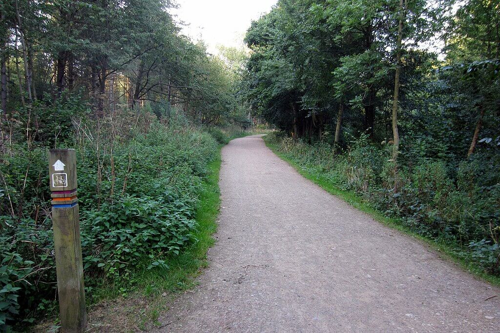 Trail in Salcey Forest – Photo Credit: Philip Jeffrey
Salcey is the largest ancient woodland in Northamptonshire, a remnant of a royal hunting forest that once covered much of the county’s south. The Woodpecker Trail, the longest of the three waymarked routes, runs for 9.7 km through a mix of surfaced tracks and earthen woodland paths, passing through stands of veteran oak, some of which are believed to be over 500 years old. The forest lies between Northampton and Newport Pagnell and the trail circles the full extent of the SSSI woodland, taking in forest rides, a disc golf course and the atmospheric Church Path Oak route along the way.
Dogs are welcome throughout Salcey and can be off the lead across most of the forest. The woodland floor is rich with the smell of damp clay soil, old mast and occasional patches of wild garlic in spring when bluebells run across the ground beneath the oaks. The surfaced sections drain well but the Woodpecker Trail proper has significant unsurfaced stretches that become deep mud after prolonged rain, so wellies or proper walking boots are advisable from autumn through to late spring. There are no livestock concerns in the main forest, so off-lead running is uncomplicated.
- Distance: 9.7 km (6 miles)
- Difficulty: Moderate
- Parking: Pay and display main car park off Wootton Road, Hartwell, NN7 2HX
- Facilities: Café, toilets, play area at main car park
- Terrain: Mix of surfaced tracks and earthen woodland paths; can be very muddy in wet weather
- Best for: Dogs who love woodland, scent-heavy environments; families with a full morning free
Brampton Valley Way from Kelmarsh
 Brampton Valley Way – Photo Credit: Mat Fascione
The Brampton Valley Way follows the trackbed of the former Northampton to Market Harborough Railway for 22.5 km end to end, but the best section for a dog walk is the stretch around Kelmarsh, entering at the old station car park and heading south to the Kelmarsh tunnel. The path here runs through open Northamptonshire countryside of rolling arable fields and hedgerow trees, the valley narrowing gradually as it climbs toward the tunnel mouth. The route passes over small bridges spanning the infant River Nene and offers long, uninterrupted views across the county.
The gravel and earth surface drains reasonably well and once away from road crossings dogs can be off the lead for the full length in either direction. The scent along the trail is typical of an old railway corridor: warm iron-tinged ballast, wild verge grasses, and in summer the faint sweetness of meadowsweet along the field edges. The tunnel itself is unlit and surprisingly cool, with dripping water and a strong echo. Dogs are fine walking through but a torch is useful. Red kites are frequently overhead on this section, and the Northampton and Lamport heritage railway runs alongside part of the trail.
- Distance: 8.0 km (5 miles) out and back from Kelmarsh
- Difficulty: Easy
- Parking: Free car park at former Kelmarsh station, off the A508, NN6 9SL area
- Facilities: None on route; pubs accessible in nearby villages
- Terrain: Compacted gravel and earth; flat throughout, shared with cyclists
- Best for: Dogs needing long off-lead miles; owners wanting an effortless flat walk
Badby Woods and Fawsley, near Daventry
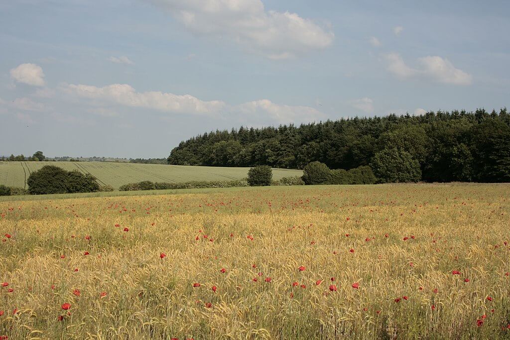 Poppy Field Overlooking Badby Woods – Photo Credit: Dorota Russell
Badby village sits at the foot of one of the more hilly corners of Northamptonshire, and the circular walk that takes in Badby Woods and the Fawsley Estate is one of the county’s most rewarding. The 12.9 km route climbs through stone and thatch Badby village, enters the woodland via the arch on the Knightley Way and winds through ancient beech and oak before dropping to the open parkland of the Fawsley Estate, with its isolated church, pretty lakes and views back toward Daventry. The return climbs back up through fields to the village.
This is Northamptonshire at its hilliest, and the ascents are genuine. Badby Wood is famous for its bluebells in late April and early May, when the ground beneath the trees turns a deep violet-blue and the air carries a light, sweet floral scent. Dogs can be off the lead in most of the woodland and parkland sections, though the Fawsley Estate itself is private so the path here is the designated Knightley Way only. The terrain is a mix of woodland earth paths, grass fields and some steeper grassy climbs; expect mud in the lower sections in winter.
- Distance: 12.9 km (8 miles)
- Difficulty: Challenging
- Parking: On-street in Badby village near The Maltsters pub, NN11 3AF
- Facilities: Dog-friendly pub in Badby village
- Terrain: Woodland paths, grass fields and steeper climbs; muddy in wet conditions
- Best for: Dogs who enjoy varied terrain and longer routes; confident walkers happy with hills
Twywell Hills and Dales, near Kettering
 Twywell Hills – Photo Credit: Dudley Miles
Twywell Hills and Dales is a nature reserve of unusual character: a former ironstone quarry near Kettering that was worked until the mid-twentieth century, now designated an SSSI and managed by the Land Trust. The quarrying left behind a sculpted landscape of ridges, gullies, steep-banked hollows and open limestone grassland that is unlike anything else in the county. The circular route of around 4.5 km takes in the open grassland of the Whitestones area, the deep wooded gullet carved by limestone extraction, and the upper fields with views toward the surrounding villages.
Dogs are welcome off the lead across most of the site, though red signage marks areas where cattle graze seasonally and leads are required when livestock are present. The scent profile here is distinctive: warm limestone dust on dry days, the sharp damp of the gullet woodland after rain, and the mineral-rich smell of the ironstone spoil heaps where the grass grows short and wildflowers push through. The reserve supports over thirty butterfly species, and the undulating terrain makes it genuinely engaging for dogs. There are no toilets or refreshments on site but the Barista Bus operates on the car park on most days through the week, and the Old Friar pub is a short walk through the site.
- Distance: 4.5 km (2.8 miles)
- Difficulty: Moderate
- Parking: Free car park at the reserve entrance, Twywell, NN14 3AL
- Facilities: No toilets on site; Barista Bus on site most days; pub in Twywell village
- Terrain: Grassy paths, natural earth tracks, steep-sided gullet with wooden boardwalks in wet areas
- Best for: Dogs who enjoy open scent-rich terrain; owners who want something genuinely different
Stoke Bruerne and Shutlanger Circular
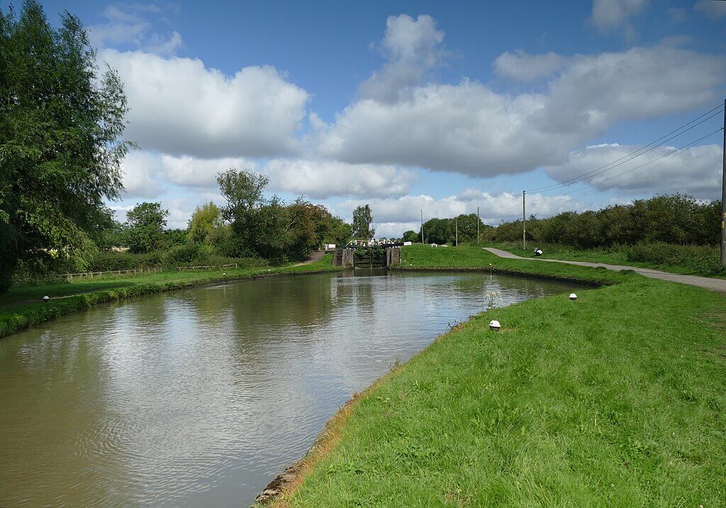 Grand Union Canal Lock at Stoke Bruerne – Photo Credit: Andy Waddington
Stoke Bruerne is the most picturesque canal village in the county, sitting on the Grand Union Canal with a working flight of locks, a canal museum, and a pair of canalside pubs. The 8 km circular walk takes the towpath north from the village to the mouth of the Blisworth Tunnel, then cuts across farmland and through the edge of Nun Wood before dropping to the quiet village of Shutlanger and looping back via open fields. The route takes in canal lock architecture, mixed woodland, open arable country and the Old Brick Pit nature reserve near the end.
Dogs can be off the lead through the woodland and field sections, with leads needed along the busy towpath and near livestock on the farmland stretches. The towpath has a firm gravel surface and the canal itself is easily accessible from the bank, making it a reliable swimming stop for dogs on warm days. The scent changes distinctly between sections: diesel and old timber on the canalside, leaf mould and bark in Nun Wood, and the sweeter grassy smell of the return fields. The Navigation Inn at Stoke Bruerne has outside seating directly overlooking the locks, making for a good finish.
- Distance: 8.0 km (5 miles)
- Difficulty: Moderate
- Parking: Pay and display at the Canal Museum, Stoke Bruerne, NN12 7SE; some on-street parking
- Facilities: Two pubs, canal museum and toilets in Stoke Bruerne
- Terrain: Firm towpath, woodland earth paths and grass field sections; one stile on route
- Best for: Dogs who like canal walking and swimming; owners wanting strong scenery
Brixworth Country Park and Pitsford Water
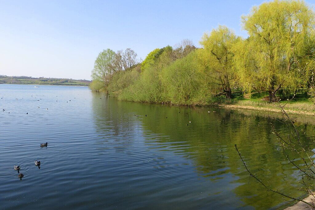 Pitsford Water – Photo Credit: Philip Jeffrey
Pitsford Water is a reservoir of around 4.5 km long and one of the county’s most popular walking destinations. The circular route of 11.3 km follows the perimeter of the reservoir entirely on a hard-surfaced track, making it one of the most accessible longer walks in Northamptonshire. Brixworth Country Park sits at the southern end where there is a café, play area and cycle hire. The walk passes through open water edge, into light woodland and across the reservoir’s narrower northern arm via a causeway, with long views across the water throughout.
The hard surface means this walk is reliable in almost all weather and the open reservoir setting means dogs and owners have visibility in every direction. The scent here is dominated by water: cold mineral sharpness from the reservoir, boggy margins where the water level draws back, and occasional reed and willow as the path nears the northern sections. Dogs are permitted off the lead on the Brixworth Country Park section and throughout the main trail, but the eastern Pitsford Water Nature Reserve section requires leads to protect the breeding bird population. Wildfowl on the water includes tufted duck, great crested grebe and goosander in winter.
- Distance: 11.3 km (7 miles)
- Difficulty: Easy
- Parking: Free car park at Brixworth Country Park, Brixworth, NN6 9DG
- Facilities: Café, toilets, cycle hire and play area at Brixworth Country Park
- Terrain: Hard-surfaced track throughout; accessible for all weather conditions
- Best for: Older dogs and less mobile owners; those wanting a reliable no-mud option
Irchester Country Park, near Wellingborough
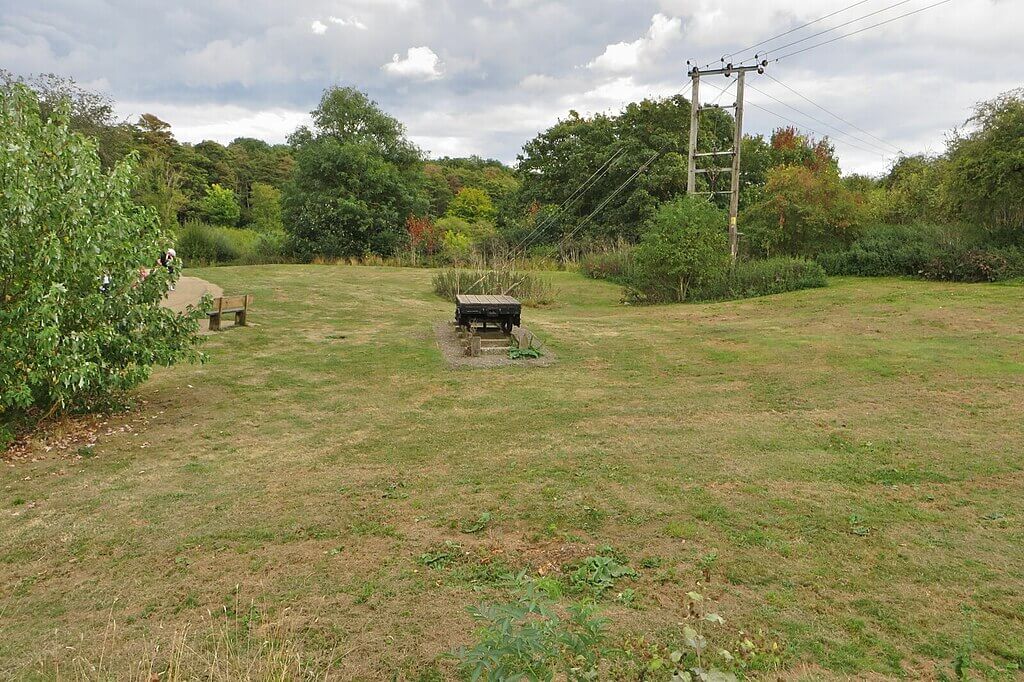 Quarry Truck in Irchester Country Park – Photo Credit: Philip Jeffrey
Irchester Country Park occupies 194 acres of former ironstone quarry southeast of Wellingborough, and the woodland that has grown across the old workings gives it a texture and interest that straightforward parkland rarely achieves. The 5 km circuit runs through mixed woodland of oak, birch and ash, passing the Ironstone Railway Museum and its narrow-gauge engines, a series of meadows, and the Cally Banks nature reserve managed by the Wildlife Trust. The quarry origin means the ground undulates in a way the local landscape generally doesn’t, with short climbs and drops that break the rhythm pleasantly.
Dogs are welcome off the lead across most of the park, with the wooded sections providing excellent scent variety: the earthy, slightly ferrous smell of the old ironstone workings beneath the leaf litter, and the deeper damp of the woodland interior after rain. Muntjac deer are present in the park and dogs should be under good control on the more enclosed woodland paths. The Quarrymen’s Rest café sits at the park’s centre and offers post-walk refreshments.
- Distance: 5.0 km (3.1 miles)
- Difficulty: Easy
- Parking: Pay and display at Gipsy Lane, Little Irchester, NN29 7DL
- Facilities: Café, toilets, play areas and free Ironstone Railway Museum
- Terrain: Mix of compacted gravel paths and earthen woodland tracks; some mud after rain
- Best for: Families with children; dogs who enjoy woodland and varied surfaces
Barnwell Country Park and the River Nene, Oundle
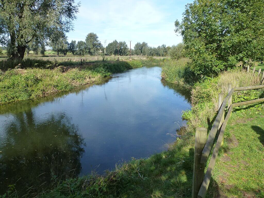 The River Nene at Barnwell Country Park – Photo Credit: Richard Humphrey
Barnwell Country Park sits on the edge of Oundle, one of the most attractive Georgian market towns in the county, and the 4 km circuit takes in a series of willow-fringed lakes and riverbank meadows in the Nene flood plain. The park is flat throughout on a mix of stone paths, boardwalk and grass, with the River Nene running along its eastern boundary. Three waymarked trails allow walks to be shortened or extended. The Kingfisher Café sits at the centre of the park with a lakeside deck and views across the water. From the park, a short walk across the river leads into Oundle itself.
The compact size of the park belies the quality of what’s on offer: dogs can reach the river from several access points on the eastern bank, and the lake edges are open enough for paddling in summer. The scent at Barnwell is dominated by water, reed and the green sweetness of the willow-edged margins, and in spring the riverside meadows carry the smell of fresh flood silt when the Nene drops. The park attracts kingfisher and grey heron along the river, and great crested grebe nest on the lakes. Leads are required during periods of avian influenza prevention zone guidance, which are signposted at the entrance.
- Distance: 4.0 km (2.5 miles)
- Difficulty: Easy
- Parking: Pay and display at Barnwell Country Park, Oundle, PE8 5PB
- Facilities: Café, toilets, play area and visitor centre
- Terrain: Hard stone paths, boardwalk and grass; flat throughout; accessible for pushchairs
- Best for: Older dogs, families with young children; easy walks close to a good town
Stanwick Lakes, Irthlingborough
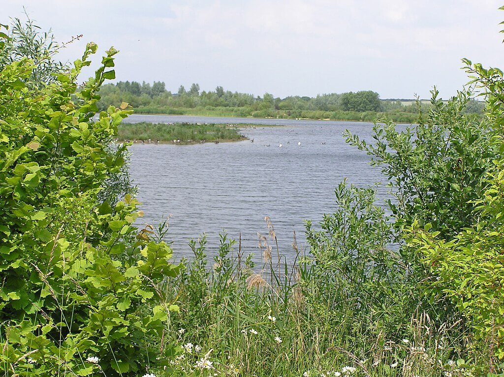 Stanwick Lakes – Photo Credit: Forester2009
Stanwick Lakes is a 750-acre nature reserve and country park built on former Nene Valley gravel workings, opened in 2006 and now one of the most significant wetland habitats in central England. The main circular Heritage Trail runs for 7.2 km through the site, passing a replica Iron Age roundhouse, carved stone markers on the sites of ancient settlements, and the old railway corridor on which dogs can be off the lead with room to run. The walking is flat throughout on good mixed surfaces, and the sheer extent of the water means the landscape opens in ways that feel genuinely expansive.
Dogs are required to be on leads throughout the site under a Public Spaces Protection Order, reflecting the park’s status as a Special Protection Area and Ramsar wetland. It is worth noting this before arriving. The lead rule is compensated for by the scale and variety of the route and the strong reward for dogs moving close to the waterside: the complex reed and algae smell of shallow gravel pit margins, the cold mineral freshness of open water, and the persistent, low-frequency scent of the resident geese and cormorant colonies. Otters are present and occasionally visible on quiet winter visits.
- Distance: 7.2 km (4.5 miles)
- Difficulty: Easy
- Parking: Pay and display at the main car park off the A45, Stanwick, NN9 6GY
- Facilities: Visitor centre, café, shop, toilets, play areas
- Terrain: Hard-surfaced paths and firm tracks; flat and accessible throughout
- Best for: Dogs and owners who enjoy large-scale wetland scenery; wildlife enthusiasts
Delapre Abbey Park, Northampton
 Delapre Abbey Park – Photo Credit: Burgess Von Thunen
Delapre Abbey Park offers 500 acres of parkland, woodland and open grassland on the southern edge of Northampton, with the walled former monastery at its centre. The walk from the Delapre Abbey car park takes in the parkland and woodland to the south, following the Nene Way down to the river washlands and returning via the lakeside path and abbey grounds. The full circuit runs for around 8.0 km, taking in mature parkland trees, riverside meadow and a section along the upper edge of the Nene flood plain.
Dogs are welcome off the lead in the parkland and woodland sections of the walk. The woodland area near the River Nene carries the warm, slightly sweet smell of floodplain willows and sedge, with notes of old timber from the bank vegetation after prolonged wet weather. The parkland itself smells of cut grass and old oak in summer, shifting to the faint earthiness of damp clay and fungi in autumn and winter. The Italian Gardens are on the route but dogs should be on leads within the formal garden enclosure, reflecting the managed planting and visiting public. Delapre Café is at the abbey and open to dog owners with dogs on leads.
- Distance: 8.0 km (5 miles)
- Difficulty: Easy
- Parking: Free car park at Delapre Abbey, London Road, Northampton, NN4 8AW
- Facilities: Café at the abbey, toilets
- Terrain: Parkland grass, well-maintained paths and some riverside sections; occasional flood risk on the Nene plain
- Best for: Dogs enjoying a mix of parkland and riverside; owners wanting an accessible walk close to Northampton
Map of Dog Friendly Walks in Northamptonshire
- Salcey Forest
- Brampton Valley Way, Kelmarsh
- Badby Woods and Fawsley
- Twywell Hills and Dales
- Stoke Bruerne and Shutlanger
- Brixworth Country Park and Pitsford Water
- Irchester Country Park
- Barnwell Country Park, Oundle
- Stanwick Lakes
- Delapre Abbey Park, Northampton
- Stoke Bruerne and Shutlanger Circular
- Salcey Forest Woodpecker Trail
These ten walks are spread across the full length of the county, from Delapre and Salcey in the south to the Nene Valley at Oundle and Stanwick in the north and east. The terrain varies significantly between sections, so use the map to choose a walk that suits your dog’s energy levels and your preference for woodland, waterside or open country.
Browse our Wildpack Map to find dog friendly walks across the UK.
Tips for Dog Walking in Northamptonshire
- Nene Valley lead rules: A Public Spaces Protection Order applies to North Northamptonshire, requiring dogs to be kept on a fixed lead of no more than two metres on land within the Upper Nene Gravel Pits Special Protection Area. This includes Stanwick Lakes and Titchmarsh Nature Reserve. Always check signage at entry points.
- Seasonal livestock grazing: Several reserves and farmland walks in the county have cattle or sheep grazing at certain times of year, including Twywell Hills and Dales and the field sections around Stoke Bruerne and Badby. Watch for signage and keep dogs close when livestock are present.
- Salcey Forest mud: The Woodpecker Trail at Salcey can become extremely muddy between October and April, and the clay-based soil holds water for extended periods after rain. Check conditions before visiting with a dog who struggles on difficult surfaces.
- Avian influenza restrictions: Barnwell Country Park and other Nene Valley sites occasionally fall within avian influenza prevention zones, particularly in winter, requiring dogs to be on leads to protect wildfowl. Signage at park entrances will indicate current restrictions.
- Bluebell season and visitor numbers: Badby Woods in late April and early May draws significant numbers of visitors, and the Chapel Lane car park fills early at weekends. Arriving before 9am gives you the woodland before the crowds, and the walk is equally good in any season.
What’s Nearby
Dog Friendly Walks in Leicestershire — River Soar valleys, Charnwood Forest and rolling wolds country to the north, with walking that includes some of the East Midlands’ best ridge-top routes.
Dog Friendly Walks in Warwickshire — Shakespeare country to the west, with canal towpaths, Arden woodland and the ironstone villages of the south making for reliably good dog walking.
Dog Friendly Walks in Oxfordshire — Cotswold stone country and Thames water meadows accessible from the county’s southern edge, with excellent off-lead woodland further north.
Dog Friendly Walks in Buckinghamshire — The Chilterns rise quickly to the south, offering beech woodland walking and chalk grassland very different in character from Northamptonshire’s river valleys.
Dog Friendly Walks in Cambridgeshire — The Nene Valley continues east into Cambridgeshire’s fens and gravel pit country, sharing a lot of the same river wetland character and big skies.
Dog Friendly Walks in Lincolnshire — To the northeast, the limestone wolds and Fens offer wide walking country with very different landscape character.