
Worcestershire sits in the West Midlands where the Malvern Hills rise abruptly from the Severn Valley, ancient woodland covers thousands of acres on the Shropshire border, and orchards run through countryside that has supplied fruit to England for centuries. The River Severn threads through the county from north to south, the canal network connects industrial towns to rural villages, and Capability Brown’s parkland at Croome demonstrates what 18th-century landscape design achieved at its peak.
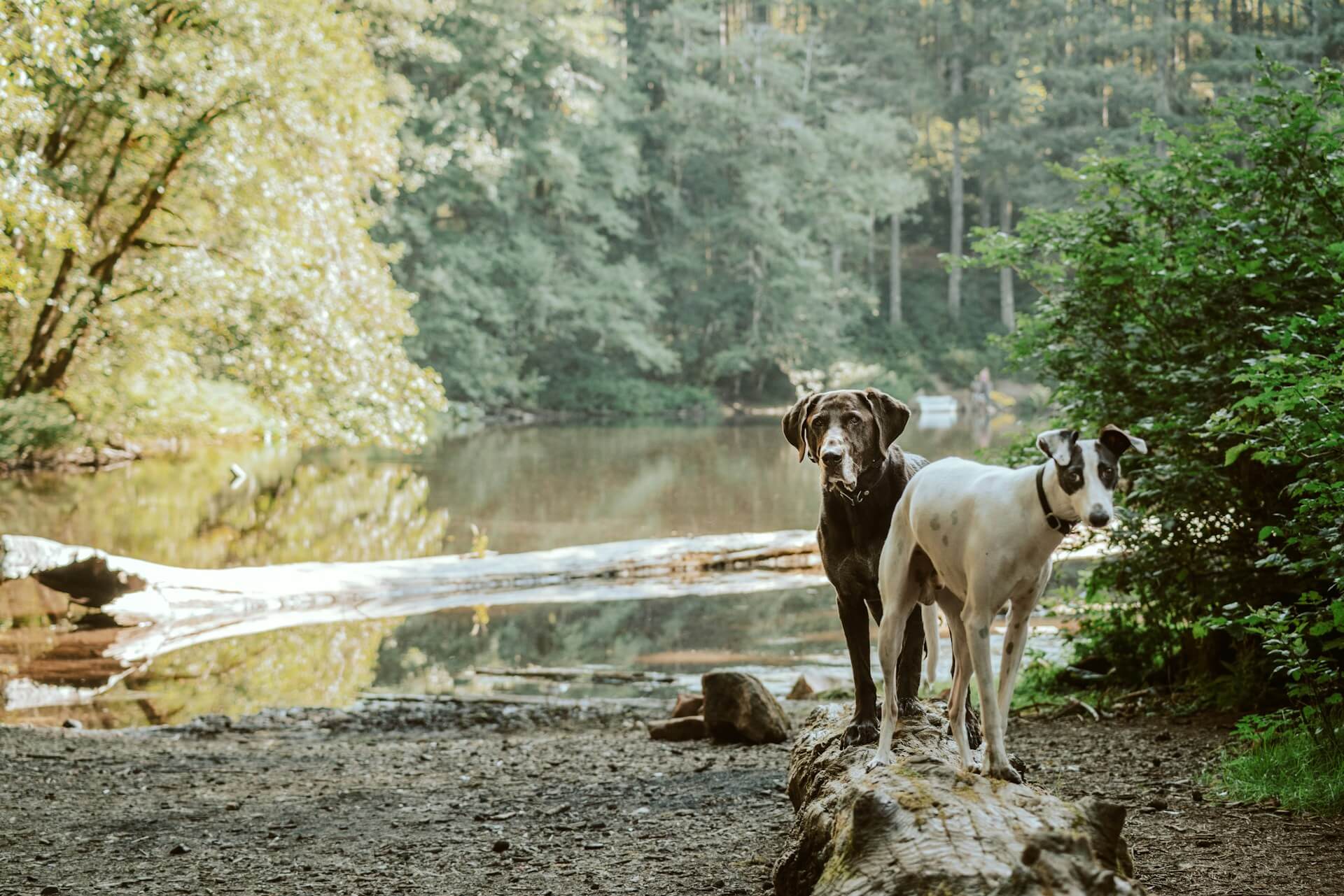
These dog friendly walks in Worcestershire cover the full range of what the county offers, from exposed ridge walking on the Malverns to deep forest trails in Wyre and riverside paths along the Severn. Every walk has been chosen for what it delivers to dogs as much as owners, with terrain that shifts constantly, water access throughout and the kind of elevation and woodland that makes Worcestershire distinctive from the flatter counties to the east.
Worcestershire Beacon and Malvern Hills Ridge
Worcestershire Beacon is the highest point of the Malvern Hills at 425 metres, and the ridge walk that takes in the summit from either British Camp or North Hill Quarry is one of the most rewarding hill walks in the Midlands. The Malverns rise suddenly from the surrounding lowland with steep eastern slopes and more gradual western approaches, and the ridge itself is exposed granite with grass, gorse and bracken covering ground that offers 360-degree views across Worcestershire, Herefordshire and into Wales.
Dogs that thrive on elevation and open ground will be thoroughly engaged here. The ridge is all exposure and wind with scent carrying differently to lowland walking, and the rabbit population keeps noses working continuously. The terrain is rough underfoot with loose rock on some sections requiring care, and leads are essential near livestock and on the steepest parts where drops are significant. The sense of space is immediate and the views are exceptional, making this proper hill walking that rewards effort with genuine satisfaction. St Ann’s Well tearoom near the summit is dog friendly.
- Distance: 11.3 km (7 miles) ridge circuit from British Camp
- Difficulty: Challenging, sustained elevation gain with rough terrain
- Parking: British Camp car park, pay and display
- Facilities: St Ann’s Well tearoom, toilets at car parks
- Terrain: Exposed ridge, rough grass and granite with steep sections
- Best for: Fit dogs that love elevation, wind and panoramic ridge walking
Wyre Forest Buzzard Trail
")
Wyre Forest is the largest woodland National Nature Reserve in England, with 6,000 acres of ancient oak woodland and planted conifers covering the Worcestershire-Shropshire border west of Bewdley. The Buzzard Trail is the longest of the waymarked routes at 8 kilometres, threading through mature oak stands, conifer plantations and sections of open ride where the canopy breaks and light floods in. The forest floor is dense with undergrowth in the broadleaf sections and the smell of resin dominates under the pines.
For dogs, Wyre delivers proper ancient woodland character with scent layers that shift between oak, ash and conifer as the trail moves through different forest types. The undergrowth is rich enough to keep scent-driven dogs engaged throughout, and the scale of the forest means there is genuine remoteness despite the proximity to Kidderminster. The forest holds roe deer and dogs register their presence immediately. The Wyre Forest Cafe at the visitor centre is dog friendly with outdoor seating and a dog wash for muddy paws after the walk.
- Distance: 8 km (5 miles) circular
- Difficulty: Easy to moderate, flat forest terrain with some gentle slopes
- Parking: Wyre Forest visitor centre car park, pay and display
- Facilities: Wyre Forest Cafe with dog wash, toilets and water bowls
- Terrain: Ancient oak woodland, conifer plantation and forest rides
- Best for: Dogs that love deep woodland, varied forest scent and proper scale
Croome Park Capability Brown Circuit
")
Croome Park is Capability Brown’s first major landscape commission, with 600 acres of parkland, woodland and water features designed in the 1750s and now managed by the National Trust. The circuit takes in the main lake, the ruined boathouse, the Island Pavilion and Park Seat viewpoint, with paths threading through parkland that demonstrates exactly what Brown achieved when landowners gave him freedom to reshape entire estates. The walking is gentle and the atmosphere is formal without feeling restrictive.
Dogs are welcome throughout on leads in most areas with designated off-lead zones clearly marked. The parkland is open enough to feel spacious while the woodland belts provide structure and shade, and the lake offers water access where banks are suitable. The combination of water, woodland and open grass in designed proportions makes this walk different to wilder countryside, and dogs respond to the variety even if the formality requires more lead work than rougher terrain. The RAF heritage adds interest and the cafe at the visitor centre is dog friendly.
- Distance: 6.4 km (4 miles) circular
- Difficulty: Easy, flat parkland paths
- Parking: Croome Park National Trust car park, pay and display or free for members
- Facilities: Visitor centre cafe with outdoor seating, toilets
- Terrain: Parkland paths, woodland rides and lakeside trails
- Best for: Dogs that enjoy formal parkland combined with water access and woodland
River Severn: Upper Arley to Bewdley
")
The River Severn between Upper Arley and Bewdley follows the western bank through woodland and open riverside meadows for 8 kilometres, with the Severn Valley Railway running parallel on the opposite bank and the sound of steam trains adding interest throughout. The path stays close to the water for most of the route with views across the river to Shropshire hills and woodland that feels genuinely remote despite the railway presence. The walking is flat and the going is good on established paths.
Dogs that love rivers will be thoroughly satisfied here. The Severn is wide and slow-moving with gravel banks where dogs can wade safely, and the riverside scent environment is excellent with water, woodland and meadow combining throughout. The railway adds movement and sound that most dogs find interesting rather than disturbing, and the linear nature of the route means there is always forward momentum. The return can be walked or taken by train if timing allows, making this a genuine A-to-B walk with public transport options.
- Distance: 8 km (5 miles) one way, 16 km (10 miles) return
- Difficulty: Easy, flat riverside path
- Parking: Upper Arley or Bewdley, pay and display
- Facilities: Pubs in Upper Arley and Bewdley, toilets at both ends
- Terrain: Riverside paths, meadows and woodland edge
- Best for: River-loving dogs and those that thrive on linear waterside walking
Worcester Woods Country Park Circuit
")
Worcester Woods Country Park sits on the southern edge of Worcester city where 100 acres of mixed woodland, meadows and ponds provide proper countryside walking within sight of the urban boundary. The park was created from farmland and ancient woodland fragments, and the network of paths connects different habitats without ever losing the sense of being in managed countryside. The woods hold oak, ash and hazel while the meadows are cut for hay and the ponds attract wildfowl year-round.
The variety here is the appeal for dogs. The woodland sections are dense enough to feel like proper forest while the meadows provide open running space and the ponds offer water access. The paths are surfaced in places and unsurfaced in others, giving different textures underfoot, and the scale is large enough for a proper walk without needing to drive further from Worcester. The cafe at the visitor centre is dog friendly with outdoor seating and the facilities are good, making this an accessible option for local walking and visitors alike.
- Distance: 4.8 km (3 miles) circular
- Difficulty: Easy, flat woodland and meadow paths
- Parking: Worcester Woods Country Park car park, free
- Facilities: Visitor centre cafe with outdoor seating, toilets
- Terrain: Mixed woodland, meadows and pond-side paths
- Best for: Dogs that need variety close to Worcester without rural driving
Gullet Quarry and Malvern Hills West
_-_geograph.org.uk_-_5089394 (1)")
_-_geograph.org.uk_-_5089394.jpg#P170)
Gullet Quarry sits on the western slopes of the Malvern Hills below Perseverance Hill, a flooded former quarry with deep clear water where dogs can swim in a dramatic setting beneath the ridge. The circuit climbs from the quarry up to the lower ridge paths before returning through woodland on the western slopes, combining water access, elevation and forest in a compact route. The quarry itself is striking and the swimming is excellent for confident water dogs.
The quarry is the centrepiece for water-loving dogs, with safe entry points and deep water that allows proper swimming rather than shallow wading. The climb to the ridge provides elevation without requiring the full ascent to Worcestershire Beacon, and the western slopes are less exposed than the main ridge making this a better option in strong wind. The woodland sections on the return are mature mixed broadleaf with good scent variety. This walk delivers Malvern Hills character without the crowds of the main peaks.
- Distance: 6.4 km (4 miles) circular
- Difficulty: Moderate, quarry to lower ridge with elevation gain
- Parking: Gullet Quarry car park, free
- Facilities: None on site, nearest facilities in Malvern Wells
- Terrain: Quarry edge, hillside paths and woodland
- Best for: Swimming dogs that want Malvern Hills walking with water access
Arrow Valley Country Park
Arrow Valley Country Park sits on the southern edge of Redditch where a reservoir, lake and river combine with woodland and meadows across 900 acres of former industrial land now restored to parkland. The circuit around Arrow Valley Lake is 4.8 kilometres of surfaced path with views across water throughout, while extensions into the surrounding woodland and meadows add distance and variety. The park combines formal amenities with wilder sections where the planting has matured into proper habitat.
Dogs find the water access and bird activity continuously engaging. The lake holds swans, geese and wildfowl that provide movement and scent interest, and the shoreline is accessible in multiple places for dogs that want to wade or swim. The woodland sections are dense enough to feel enclosed and the meadows provide open running space when livestock are absent. The surfaced paths make the walking accessible year-round and the facilities at the visitor centre include a dog-friendly cafe with outdoor seating and water bowls.
- Distance: 4.8 km to 11.3 km (3 to 7 miles) depending on route choice
- Difficulty: Easy, flat lakeside and parkland paths
- Parking: Arrow Valley Country Park car park, free
- Facilities: Visitor centre cafe, toilets and picnic areas
- Terrain: Lakeside paths, woodland tracks and meadows
- Best for: Water-loving dogs and those needing accessible parkland with variety
Shrawley Wood
")
Shrawley Wood is one of the largest small-leaved lime woodlands in England, with 74 acres of ancient semi-natural woodland between the River Severn and the village of Shrawley north of Worcester. The wood is Wildlife Trust managed and holds a spring bluebell display that is among the best in Worcestershire, with the lime canopy creating the kind of light conditions that encourage dense ground flora. The paths thread through the wood in rough circuits without waymarking, making this genuine woodland exploration.
Dogs that respond to ancient woodland scent will be thoroughly satisfied here. The lime canopy creates a distinctive smell different to oak or beech woods, and the undergrowth is rich enough to keep noses working throughout. The lack of waymarking means following instinct rather than prescribed routes, which suits confident walkers and dogs that stay close. The wood is compact enough that getting genuinely lost is difficult, and the bluebell season in late April and early May is worth timing the visit for. Quiet, unsurfaced and properly wild despite being small.
- Distance: 3.2 km (2 miles) circular or longer if extending
- Difficulty: Easy, flat woodland with unsurfaced paths
- Parking: Limited roadside parking near Shrawley village
- Facilities: None on site, nearest facilities in Shrawley
- Terrain: Ancient lime woodland with bluebell ground flora
- Best for: Dogs that love dense ancient woodland and bluebell season walking
Broadway Tower and Cotswolds Escarpment
")
Broadway Tower sits on the Cotswolds escarpment at 312 metres where Worcestershire meets the Cotswolds AONB, with views across the Vale of Evesham and the tower itself marking the second-highest point in the Cotswolds. The walk from Broadway village climbs steadily through fields and woodland to the escarpment top, with the tower visible throughout as a destination marker. The views from the top are exceptional and the sense of being on the edge of something significant is immediate.
Dogs that enjoy proper elevation gain and escarpment walking will thrive here. The climb is sustained but not technical, and the grassland on top provides running space with views that extend for miles. The tower grounds hold a cafe with outdoor seating and deer park where fallow deer graze, adding movement that dogs register immediately. The return descent through woodland on the escarpment slope provides shade and different terrain, making this a walk with variety despite the single objective. Seasonal grazing requires lead work in fields.
- Distance: 6.4 km (4 miles) circular
- Difficulty: Moderate, sustained climb to escarpment top
- Parking: Broadway village car parks, pay and display
- Facilities: Broadway Tower cafe with outdoor seating, toilets
- Terrain: Village paths, farmland, escarpment grassland and woodland
- Best for: Dogs that love elevation gain, escarpment views and deer-rich parkland
Hanbury Hall Estate Circuit
")
Hanbury Hall is a National Trust property east of Droitwich with 400 acres of parkland, woodland and canal towpath in a circuit that moves between different landscape types throughout. The hall itself sits in formal grounds while the estate extends to farmland, mature woodland and a section of the Worcester and Birmingham Canal that provides towpath walking distinct from the parkland sections. The circuit is gentle and the variety is the appeal rather than dramatic scenery.
Dogs welcome throughout on leads in most areas, with the estate large enough to absorb the formality without feeling restrictive. The parkland provides open walking while the woodland is dense enough to feel like proper forest, and the canal section adds water and the steady rhythm of towpath walking. The combination of designed landscape and working countryside makes this walk more interesting than the sum of its parts. The cafe in the old laundry is dog friendly with outdoor seating and the facilities are good.
- Distance: 6.4 km (4 miles) circular
- Difficulty: Easy, flat estate paths
- Parking: Hanbury Hall National Trust car park, pay and display or free for members
- Facilities: Cafe with outdoor seating, toilets
- Terrain: Parkland, woodland and canal towpath
- Best for: Dogs that enjoy varied estate walking combining parkland with working countryside
Map of Dog Friendly Walks in Worcestershire
Use the map below to explore all ten walks. Worcestershire’s geography means the Malvern Hills dominate the western edge while the Severn Valley and canal network provide lowland routes, making route selection straightforward based on elevation preference.
Hanbury Hall is a National Trust property east of Droitwich with 400 acres of parkland, woodland and canal towpath in a circuit moving between different landscape types throughout. The hall sits in formal grounds while the estate extends to farmland, mature woodland and a section of the Worcester and Birmingham Canal providing towpath walking distinct from parkland sections. The circuit is gentle and variety is the appeal rather than dramatic scenery.
Dogs welcome throughout on leads in most areas, with the estate large enough to absorb formality without feeling restrictive. Parkland provides open walking while woodland is dense enough to feel like proper forest, and the canal section adds water and steady rhythm of towpath walking. The combination of designed landscape and working countryside makes this more interesting than the sum of its parts. The cafe in the old laundry is dog friendly with outdoor seating.
- Distance: 6.4 km (4 miles) circular
- Difficulty: Easy, flat estate paths
- Parking: Hanbury Hall National Trust car park, pay and display or free for members
- Facilities: Cafe with outdoor seating, toilets
- Terrain: Parkland, woodland and canal towpath
- Best for: Dogs that enjoy varied estate walking combining parkland with working countryside
Broadway Tower sits on the Cotswolds escarpment at 312 metres where Worcestershire meets the Cotswolds AONB, with views across the Vale of Evesham and the tower marking the second-highest point in the Cotswolds. The walk from Broadway village climbs steadily through fields and woodland to the escarpment top with the tower visible throughout as a destination marker. Views from the top are exceptional and the sense of being on the edge of something significant is immediate.
Dogs that enjoy proper elevation gain and escarpment walking will thrive here. The climb is sustained but not technical, and grassland on top provides running space with views extending for miles. The tower grounds hold a cafe with outdoor seating and deer park where fallow deer graze, adding movement dogs register immediately. The return descent through woodland on the escarpment slope provides shade and different terrain, making this a walk with variety despite the single objective.
- Distance: 6.4 km (4 miles) circular
- Difficulty: Moderate, sustained climb to escarpment top
- Parking: Broadway village car parks, pay and display
- Facilities: Broadway Tower cafe with outdoor seating, toilets
- Terrain: Village paths, farmland, escarpment grassland and woodland
- Best for: Dogs that love elevation gain, escarpment views and deer-rich parkland
Shrawley Wood is one of the largest small-leaved lime woodlands in England with 74 acres of ancient semi-natural woodland between the River Severn and the village of Shrawley north of Worcester. The wood is Wildlife Trust managed and holds a spring bluebell display among the best in Worcestershire, with the lime canopy creating light conditions that encourage dense ground flora. Paths thread through the wood in rough circuits without waymarking, making this genuine woodland exploration.
Dogs that respond to ancient woodland scent will be thoroughly satisfied. The lime canopy creates a distinctive smell different to oak or beech woods, and undergrowth is rich enough to keep noses working throughout. The lack of waymarking means following instinct rather than prescribed routes, which suits confident walkers and dogs that stay close. The wood is compact enough that getting genuinely lost is difficult, and the bluebell season in late April and early May is worth timing visits for.
- Distance: 3.2 km (2 miles) circular or longer if extending
- Difficulty: Easy, flat woodland with unsurfaced paths
- Parking: Limited roadside parking near Shrawley village
- Facilities: None on site, nearest facilities in Shrawley
- Terrain: Ancient lime woodland with bluebell ground flora
- Best for: Dogs that love dense ancient woodland and bluebell season walking
Arrow Valley Country Park sits on the southern edge of Redditch where a reservoir, lake and river combine with woodland and meadows across 900 acres of former industrial land now restored to parkland. The circuit around Arrow Valley Lake is 4.8 kilometres of surfaced path with views across water throughout, while extensions into surrounding woodland and meadows add distance and variety. The park combines formal amenities with wilder sections where planting has matured into proper habitat.
Dogs find the water access and bird activity continuously engaging. The lake holds swans, geese and wildfowl providing movement and scent interest, and the shoreline is accessible in multiple places for dogs that want to wade or swim. Woodland sections are dense enough to feel enclosed and meadows provide open running space when livestock are absent. Surfaced paths make walking accessible year-round and facilities include a dog-friendly cafe with outdoor seating and water bowls.
- Distance: 4.8 km to 11.3 km (3 to 7 miles) depending on route choice
- Difficulty: Easy, flat lakeside and parkland paths
- Parking: Arrow Valley Country Park car park, free
- Facilities: Visitor centre cafe, toilets and picnic areas
- Terrain: Lakeside paths, woodland tracks and meadows
- Best for: Water-loving dogs and those needing accessible parkland with variety
Gullet Quarry sits on the western slopes of the Malvern Hills below Perseverance Hill, a flooded former quarry with deep clear water where dogs can swim in a dramatic setting beneath the ridge. The circuit climbs from the quarry up to the lower ridge paths before returning through woodland on western slopes, combining water access, elevation and forest in a compact route. The quarry itself is striking and swimming is excellent for confident water dogs.
The quarry is the centrepiece for water-loving dogs with safe entry points and deep water allowing proper swimming rather than shallow wading. The climb to the ridge provides elevation without requiring full ascent to Worcestershire Beacon, and western slopes are less exposed than the main ridge making this better in strong wind. Woodland sections on the return are mature mixed broadleaf with good scent variety. This delivers Malvern Hills character without the crowds of main peaks.
- Distance: 6.4 km (4 miles) circular
- Difficulty: Moderate, quarry to lower ridge with elevation gain
- Parking: Gullet Quarry car park, free
- Facilities: None on site, nearest facilities in Malvern Wells
- Terrain: Quarry edge, hillside paths and woodland
- Best for: Swimming dogs that want Malvern Hills walking with water access
Worcester Woods Country Park sits on the southern edge of Worcester city where 100 acres of mixed woodland, meadows and ponds provide proper countryside walking within sight of the urban boundary. The park was created from farmland and ancient woodland fragments, and the network of paths connects different habitats without losing the sense of managed countryside. The woods hold oak, ash and hazel while meadows are cut for hay and ponds attract wildfowl year-round.
The variety here is the appeal for dogs. Woodland sections are dense enough to feel like proper forest while meadows provide open running space and ponds offer water access. Paths are surfaced in places and unsurfaced in others giving different textures underfoot, and the scale is large enough for a proper walk without needing to drive further from Worcester. The cafe at the visitor centre is dog friendly with outdoor seating.
- Distance: 4.8 km (3 miles) circular
- Difficulty: Easy, flat woodland and meadow paths
- Parking: Worcester Woods Country Park car park, free
- Facilities: Visitor centre cafe with outdoor seating, toilets
- Terrain: Mixed woodland, meadows and pond-side paths
- Best for: Dogs that need variety close to Worcester without rural driving
The River Severn between Upper Arley and Bewdley follows the western bank through woodland and open riverside meadows for 8 kilometres, with the Severn Valley Railway running parallel on the opposite bank and the sound of steam trains adding interest throughout. The path stays close to water for most of the route with views across the river to Shropshire hills and woodland that feels genuinely remote despite railway presence.
Dogs that love rivers will be thoroughly satisfied. The Severn is wide and slow-moving with gravel banks where dogs can wade safely, and the riverside scent environment is excellent with water, woodland and meadow combining throughout. The railway adds movement and sound that most dogs find interesting rather than disturbing. The linear nature means there is always forward momentum, and the return can be walked or taken by train if timing allows.
- Distance: 8 km (5 miles) one way, 16 km (10 miles) return
- Difficulty: Easy, flat riverside path
- Parking: Upper Arley or Bewdley, pay and display
- Facilities: Pubs in Upper Arley and Bewdley, toilets at both ends
- Terrain: Riverside paths, meadows and woodland edge
- Best for: River-loving dogs and those that thrive on linear waterside walking
Croome Park is Capability Brown’s first major landscape commission with 600 acres of parkland, woodland and water features designed in the 1750s and now managed by the National Trust. The circuit takes in the main lake, the ruined boathouse, the Island Pavilion and Park Seat viewpoint, with paths threading through parkland that demonstrates exactly what Brown achieved when landowners gave him freedom to reshape entire estates.
Dogs are welcome throughout on leads in most areas with designated off-lead zones clearly marked. The parkland is open enough to feel spacious while woodland belts provide structure and shade, and the lake offers water access where banks are suitable. The combination of water, woodland and open grass in designed proportions makes this walk different to wilder countryside. The RAF heritage adds interest and the cafe at the visitor centre is dog friendly with outdoor seating.
- Distance: 6.4 km (4 miles) circular
- Difficulty: Easy, flat parkland paths
- Parking: Croome Park National Trust car park, pay and display or free for members
- Facilities: Visitor centre cafe with outdoor seating, toilets
- Terrain: Parkland paths, woodland rides and lakeside trails
- Best for: Dogs that enjoy formal parkland combined with water access and woodland
Wyre Forest is the largest woodland National Nature Reserve in England with 6,000 acres of ancient oak woodland and planted conifers covering the Worcestershire-Shropshire border west of Bewdley. The Buzzard Trail is the longest waymarked route at 8 kilometres, threading through mature oak stands, conifer plantations and sections of open ride where canopy breaks and light floods in. The forest floor is dense with undergrowth in broadleaf sections and the smell of resin dominates under pines.
For dogs, Wyre delivers proper ancient woodland character with scent layers that shift between oak, ash and conifer as the trail moves through different forest types. Undergrowth is rich enough to keep scent-driven dogs engaged throughout and the scale of the forest means genuine remoteness despite proximity to Kidderminster. The forest holds roe deer and dogs register their presence immediately. The Wyre Forest Cafe is dog friendly with outdoor seating and a dog wash for muddy paws.
- Distance: 8 km (5 miles) circular
- Difficulty: Easy to moderate, flat forest terrain with some gentle slopes
- Parking: Wyre Forest visitor centre car park, pay and display
- Facilities: Wyre Forest Cafe with dog wash, toilets and water bowls
- Terrain: Ancient oak woodland, conifer plantation and forest rides
- Best for: Dogs that love deep woodland, varied forest scent and proper scale
Worcestershire Beacon is the highest point of the Malvern Hills at 425 metres and the ridge walk taking in the summit is one of the most rewarding hill walks in the Midlands. The Malverns rise suddenly from surrounding lowland with steep eastern slopes and more gradual western approaches, and the ridge itself is exposed granite with grass, gorse and bracken offering 360-degree views across Worcestershire, Herefordshire and into Wales.
Dogs that thrive on elevation and open ground will be thoroughly engaged. The ridge is all exposure and wind with scent carrying differently to lowland walking, and the rabbit population keeps noses working continuously. Terrain is rough underfoot with loose rock on some sections requiring care, and leads are essential near livestock and on steepest parts where drops are significant. The sense of space is immediate and views are exceptional, making this proper hill walking that rewards effort with genuine satisfaction.
- Distance: 11.3 km (7 miles) ridge circuit from British Camp
- Difficulty: Challenging, sustained elevation gain with rough terrain
- Parking: British Camp car park, pay and display
- Facilities: St Ann’s Well tearoom, toilets at car parks
- Terrain: Exposed ridge, rough grass and granite with steep sections
- Best for: Fit dogs that love elevation, wind and panoramic ridge walking
Explore dog friendly walks across the UK on our Wildpack Map.
Tips for Walking in Worcestershire
Worcestershire’s walking landscape ranges from proper hill country to gentle parkland, with a few considerations making the difference between good and excellent walks.
- The Malvern Hills are exposed and weather changes rapidly, waterproofs and layers are essential regardless of valley conditions
- Malvern ridge paths are rough underfoot with loose rock on steeper sections, proper boots make a significant difference
- Wyre Forest stays muddy in sections year-round, the main trails are better surfaced but woodland paths hold water
- River Severn paths can flood in winter and spring, worth checking conditions before travelling in wet periods
- Ticks are present in woodland and grassland, checking dogs after walks is standard practice
- Water access is excellent throughout via rivers, canals and park lakes, most sites allow swimming
- National Trust sites require parking payment or membership, country parks are generally free
- Grazing animals are present seasonally on the Malverns and in parkland, leads required when livestock present
What’s Nearby?
If you are spending time in Worcestershire with your dog, the surrounding counties offer further opportunities beyond the walks in this guide.
- Dog friendly walks in Herefordshire – the Wye Valley, Black Mountains and rural borderland countryside
- Dog friendly walks in Warwickshire – canal towpaths, country parks and Stratford-upon-Avon countryside
- Dog friendly walks in Leicestershire – Bradgate Park, canal networks and rolling countryside
- Dog friendly walks in The Cotswolds – limestone grassland, beech woodland and honey-stone villages along the eastern boundary