

Sussex is one of England’s most walked counties, and it earns that reputation. The South Downs run the full width of East and West Sussex as a continuous chalk ridge, dropping to the coast in a sequence of white cliffs between Brighton and Eastbourne. Behind and north of the Downs lies the ancient Weald, deep oak and hornbeam woodland, hammer ponds left by the iron industry, and quiet river valleys that wind toward the Kent and Surrey borders. The county has a compactness and variety that rewards walkers who stay for more than a day: the terrain shifts from open downland to enclosed forest to shingle beach within a matter of kilometres.
For dog owners, Sussex asks for a little forward planning. The South Downs National Park covers much of the central county and livestock are a constant presence on the chalk ridge, particularly cattle and sheep on the more exposed flanks. Lead discipline matters on the Downs, especially in spring lambing season. But the infrastructure for dog walking here is genuinely good: the South Downs Way provides a reliable spine of well-signed walking, the Weald offers off-lead woodland freedom for much of the year, and the shingle coastline east of Brighton provides beach access for most of the year outside the busiest summer months.
Beachy Head and the Seven Sisters
")
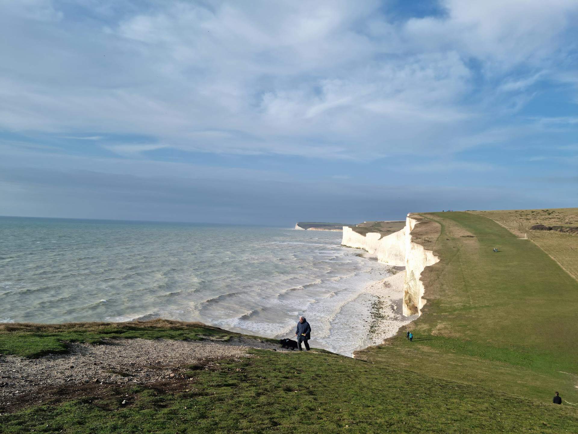
The Seven Sisters chalk cliffs are among the most photographed landscapes in England, and the coastal walk between Birling Gap and Cuckmere Haven covers the full sequence in a spectacular out-and-back or one-way route. From the Birling Gap car park, the path follows the cliff top east across each of the seven Sisters before dropping into the Cuckmere valley at Exceat. The full one-way distance is 9.8 km (6.1 miles), usually walked with a car shuttle or taxi return. The cliff top walking is entirely exposed and the views across the Channel on a clear day extend to the French coast.
Dogs find this a high-stimulation environment: sea air layered with salt and kelp, downland turf rich with rabbit warrens, and the open sky above the cliff edge creating a sense of complete exposure that some dogs find intoxicating. The chalk turf is firm and springy underfoot in dry weather. Dogs must be on leads near the cliff edges, the drops are sheer and the edge is unfenced at many points. Sheep graze the downland slopes above the cliffs and leads are required through grazed sections regardless. This is not a walk for an off lead dog without good recall when called away from the edge.
- Distance: 9.8 km (6.1 miles) one way
- Difficulty: Moderate
- Parking: Birling Gap National Trust car park, BN20 0AB
- Facilities: National Trust café at Birling Gap; toilets on site
- Terrain: Chalk cliff top turf, firm in dry conditions, slippery on wet chalk after rain
- Best for: Confident dogs with solid recall; spectacular in clear weather at any time of year
The South Downs Way — Devil’s Dyke to Fulking
")
Devil’s Dyke is the most dramatic feature on the West Sussex section of the South Downs, a V-shaped dry valley cut into the chalk escarpment north of Brighton with views across the Low Weald that extend on clear days to the North Downs. The walk from the Devil’s Dyke car park follows the ridge west to Edburton Hill and back via the foot of the scarp through the village of Fulking, making a circuit of around 10.2 km (6.3 miles). The ridge section gives big open walking with almost no tree cover, while the return through Fulking passes a pub with an excellent dog-friendly reputation.
The chalk turf here carries the characteristic dry mineral smell of the Downs — thin soil, thyme, and the faint sweetness of rabbit. The views north into the Weald give dogs an extraordinary acoustic as well as visual environment, open to wind and birdsong with little shelter. Cattle graze the valley bottom and the slopes near Fulking, so leads are required through those sections; the ridge itself is often grazed by sheep. The Shepherd and Dog pub in Fulking welcomes dogs and makes an excellent mid-walk or end-of-walk stop.
- Distance: 10.2 km (6.3 miles)
- Difficulty: Moderate
- Parking: National Trust car park at Devil’s Dyke, BN1 8YJ
- Facilities: Pub at Devil’s Dyke (dog-friendly patio); The Shepherd and Dog in Fulking
- Terrain: Chalk ridge turf, field paths, quiet village lanes
- Best for: Dogs who enjoy open downland; owners who want a pub stop on the route
Ashdown Forest — Gills Lap and Chuck Hatch
")
Ashdown Forest is the largest area of open heath in the South East of England, a high plateau of heather, gorse, and acid grassland that forms the source of several rivers including the Medway and the Ouse. The walk from the Gills Lap car park, one of the original Winnie-the-Pooh filming locations, takes in the open heathland plateau, dips into the birch and oak woodland around Chuck Hatch, and returns across the high ridge with long views in every direction. The circuit is around 7.5 km (4.7 miles) and is largely on well-maintained sandy paths.
The heathland carries the distinctive dry, clean smell of warm sand and heather, cut through with the sharp sweetness of gorse when in flower. Ashdown Forest is largely unfenced and dogs can range well on the open heath sections, though ground-nesting birds are present on the heathland from March to August and dogs should be kept close during this period. Signs will indicate sensitive areas. The sandy paths drain well and this is one of the county’s best all-weather walks, remaining accessible and relatively dry after rain when the clay Weald below is sodden. Bring water as there is none on the high heath.
- Distance: 7.5 km (4.7 miles)
- Difficulty: Easy to Moderate
- Parking: Gills Lap car park, Hartfield, TN7 4HE
- Facilities: None on route; the Hatch Inn at Chuck Hatch welcomes dogs
- Terrain: Sandy heathland paths, some woodland tracks — excellent drainage
- Best for: Dogs who love open space and heathland; ideal for all seasons except nesting season without care
Cissbury Ring and the Findon Valley
")
Cissbury Ring is the largest Iron Age hillfort in Sussex, a great oval earthwork sitting on the chalk escarpment above Worthing with views across to the Isle of Wight on clear days. The walk from the Storrington Rise car park follows the South Downs Way onto the escarpment, circles the outside and inside of the fort’s massive ramparts, and returns via the Findon Valley on a quieter path through chalk grassland and mixed scrub. The full circuit is 8.2 km (5.1 miles) with a gentle climb to the ridge.
The interior of the hillfort is an extraordinary space for dogs: a wide, slightly bowl-shaped plateau of sheep-grazed chalk grassland where the old Norman flint mines create hummocky ground full of rabbit scent. Sheep graze the interior for much of the year, so leads are essential inside and on the ramparts. The valley return is often quieter and allows more relaxed off-lead walking in the sections between grazed fields. The smell of the chalk interior is distinctive: dry, mineral turf with a thread of lanolin from the sheep and the occasional sweet waft of wild marjoram in summer.
- Distance: 8.2 km (5.1 miles)
- Difficulty: Moderate
- Parking: Cissbury Ring National Trust car park, Worthing, BN14 0HU
- Facilities: None on site; Worthing town centre 5 km south
- Terrain: Chalk grassland, earthwork ramparts, some rough ground inside the fort
- Best for: Dogs who enjoy open grassland and rabbit-rich ground; a good choice for a half-day without needing full facilities nearby
Bewl Water: Full Reservoir Circuit
")
Bewl Water is the largest reservoir in the South East, a 770-acre lake on the East Sussex and Kent border surrounded by managed woodland and open grassland. The full circuit of the reservoir path runs to 22 km (13.7 miles) and is a well-known challenge for committed walkers, but a shorter 10 km (6.2 miles) northern section makes an excellent half-day route taking in the main dam, the wooded eastern shore, and the open grassland above the western inlet. The path is clearly waymarked throughout and the lake views are attractive in all weather.
The reservoir shore combines the fresh, slightly mineral smell of still water with the surrounding mixed woodland, creating a layered scent environment that keeps dogs interested throughout. The path is well maintained and mostly flat, with a couple of short rises over headlands between the inlets. Dogs can access the water at several gravel beaches along the shore and swimming is permitted in most sections. The path can be busy at weekends near the visitor centre, but the eastern shore sees far fewer people even in summer. Leads are required near the visitor centre and its adjacent facilities.
- Distance: 10 km (6.2 miles) for the shorter northern loop
- Difficulty: Easy
- Parking: Bewl Water visitor centre car park, Lamberhurst, TN3 8JH
- Facilities: Visitor centre café and toilets; cycle and kayak hire available
- Terrain: Mostly flat gravel and grass path around the shoreline
- Best for: Older dogs and owners wanting flat, easy walking with consistent water access
Friston Forest and the Cuckmere Valley
")
Friston Forest is a large block of managed chalk woodland immediately west of the Seven Sisters, planted on the downland above Eastbourne. The walk from the Westdean car park descends through the forest to the meandering Cuckmere river, follows the valley bottom past the beautiful flint village of Alfriston, and loops back through the forest edge and downland. The full circuit is 10.5 km (6.5 miles) and takes in the most varied terrain of any walk in this list: chalk woodland, river meadow, and open downland all within the same route.
The forest has the enclosed, resinous smell of chalk woodland: a mix of yew, ash, and beech rather than the conifer scent of plantation forests further north. Dogs find the transition from forest to open river valley dramatic, and the Cuckmere floodplain is one of the finest off-lead stretches in East Sussex when no cattle are present, wide, flat, and green with the river running clear and cold alongside. The village of Alfriston has several dog-friendly pubs and is a natural mid-route stop. The river itself can be accessed at several shallow points for paddling.
- Distance: 10.5 km (6.5 miles)
- Difficulty: Moderate
- Parking: Westdean car park near Exceat, BN25 4AB
- Facilities: Pubs and cafés in Alfriston; toilets at Exceat Countryside Centre
- Terrain: Forest tracks, river meadow, chalk downland. Meadow sections can flood in winter
- Best for: Dogs who enjoy river access and woodland; excellent for a full day with a lunch stop
Ditchling Beacon and the South Downs Ridge East
Ditchling Beacon is the highest point in East Sussex at 248 metres, and the ridge walk east from the beacon car park toward Plumpton along the South Downs Way is one of the finest stretches of open downland walking in the county. The out-and-back to Plumpton Green car park and back covers 10.8 km (6.7 miles) along a wide, well-defined chalk ridge with panoramic views over the Weald to the north and the coastal plain to the south. The beacon itself is a National Nature Reserve and the downland turf here contains an exceptional diversity of chalk wildflowers from May through August.
The ridge in summer carries the warm, honeyed smell of chalk wildflowers: orchids, scabious, and trefoil, overlaid on the dry mineral chalk turf below. Cattle and sheep are regularly grazed along this section of the ridge to maintain the grassland character, and leads are required throughout when livestock are present. The path is wide and clear and the turf is firm in dry weather, though it becomes slippery on wet chalk. No water on the ridge; carry enough for your dog. The views, particularly north into the Weald on a clear morning, are among the best in the county.
- Distance: 10.8 km (6.7 miles)
- Difficulty: Moderate
- Parking: Ditchling Beacon National Nature Reserve car park, BN6 8XG
- Facilities: None on route; Brighton 12 km south with full facilities
- Terrain: Open chalk ridge, firm in dry conditions, slippery when wet
- Best for: Dogs comfortable with regular livestock; walkers who want uninterrupted ridge views
Petworth Park
")
Petworth is one of the finest landscape parks in England, a 700-acre deer park designed by Capability Brown and preserved almost entirely in its eighteenth-century form by the National Trust. The informal walking circuit of the park from the town car park takes in the main sweep of parkland, the lakeshore, the ha-ha wall bordering the house garden, and the ancient oak woodland at the north end of the estate. The main circuit is around 5.2 km (3.2 miles) and is entirely flat, making it the most accessible walk in this list.
The park has a particular smell in autumn and winter: old grass, the sweet rot of fallen leaves, and the persistent musk of the fallow deer that have roamed here for centuries. The deer herd is a significant presence and dogs must be on leads throughout the park to avoid disturbing them; this is a strict and well-enforced rule. Despite this restriction, the park’s open spaces and extraordinary ancient oaks make it a genuinely memorable walk even for energetic dogs who need a steadier day. The town of Petworth immediately outside the gates has dog-friendly cafés and pubs for a post-walk stop.
- Distance: 5.2 km (3.2 miles)
- Difficulty: Easy
- Parking: National Trust car park in Petworth town, GU28 0LF
- Facilities: National Trust café and toilets at the park entrance; town facilities in Petworth
- Terrain: Mown parkland grass, gravel paths, completely flat
- Best for: Older dogs and owners wanting a calm, easy walk with outstanding landscape
St Leonard’s Forest and Crabtree
")
St Leonard’s Forest is an ancient High Weald woodland to the east of Horsham, covering several thousand acres of oak and birch on a ridge of Wealden sandstone. The walk from the Mick Mills car park follows the main forest track south through the core of the woodland, loops around the hammer ponds at Crabtree, and returns via a quieter bridleway through younger growth. The circuit is around 8.4 km (5.2 miles) and the forest is quiet and relatively underused compared to the more famous Ashdown Forest to the east.
The forest floor carries the deep, complex smell of Wealden woodland: ancient oak and sweet chestnut, the cold iron tang of the hammer pond water, and the damp earth under a heavy canopy that shuts out the sky on summer days. Dogs can range off-lead through most of the forest on the quieter bridleways, and the hammer ponds offer water access at several safe entry points. The ground is damp and holds mud from November through March. This is High Weald clay, not chalk, and boots are strongly recommended in the wet season. Deer are present in good numbers and some dogs will need management near the pond edges.
- Distance: 8.4 km (5.2 miles)
- Difficulty: Moderate
- Parking: Mick Mills car park, St Leonard’s Forest, RH13 6NF
- Facilities: None on route; Horsham town centre 8 km west
- Terrain: Forest tracks and bridleways, clay soil, muddy from November to March
- Best for: Dogs who love deep woodland and water; less suitable in wet conditions for short-coated breeds
Amberley and the Wild Brooks
")
The Wild Brooks are an extraordinary area of low-lying, seasonally flooded meadow and fen in the Arun Valley west of Pulborough, managed as a nature reserve. The walk from Amberley village follows the South Downs Way to the escarpment edge, then drops into the valley and crosses the Brooks on raised paths before looping back through the ancient village. The full circuit is 7.6 km (4.7 miles) and combines the open chalk ridge with the completely contrasting flatness of the valley floor. Amberley itself is one of the most beautiful villages in West Sussex.
The Brooks carry a rich, green smell of wetland: reed, watermint, and the faint sulphurous trace of peat, quite unlike anywhere else in the county. Wading birds and wildfowl are present in large numbers, particularly in winter, and dogs should be under close control on the raised paths through the reserve where flushes of snipe and lapwing can be disturbed easily. The chalk descent from the village is firm and the views from the scarp edge across the Arun valley are exceptional. The valley paths can be partially flooded between November and April and some sections may be impassable after heavy rain.
- Distance: 7.6 km (4.7 miles)
- Difficulty: Moderate
- Parking: Roadside parking in Amberley village, BN18 9ND
- Facilities: The Sportsman pub in Amberley welcomes dogs; Amberley Museum and Heritage Centre nearby
- Terrain: Chalk ridge, raised causeway paths through wetland. Some sections flood in winter
- Best for: Dogs comfortable near birds; owners who want a varied landscape combining downland and wetland
Map of Dog Friendly Walks in Sussex
The walks in this list span both East and West Sussex, from the chalk cliffs of the Seven Sisters on the coast to the High Wealden forest around Horsham in the north. The map below shows the full geographic spread across the county and can help you plan based on where you are based.
The Wild Brooks are an extraordinary area of low-lying, seasonally flooded meadow and fen in the Arun Valley west of Pulborough, managed as a nature reserve. The walk from Amberley village follows the South Downs Way to the escarpment edge, drops into the valley and crosses the Brooks on raised paths, before looping back through the ancient village. The full circuit is 7.6 km (4.7 miles) and combines open chalk ridge with the completely contrasting flatness of the valley floor.
The Brooks carry a rich, green smell of wetland: reed, watermint, and the faint sulphurous trace of peat, quite unlike anywhere else in the county. Wading birds and wildfowl are present in large numbers, particularly in winter, and dogs should be under close control on the raised paths where flushes of snipe and lapwing can be disturbed easily. The valley paths can be partially flooded between November and April and some sections may be impassable after heavy rain.
- Distance: 7.6 km (4.7 miles)
- Difficulty: Moderate
- Parking: Roadside parking in Amberley village, BN18 9ND
- Facilities: The Sportsman pub in Amberley welcomes dogs; Amberley Museum and Heritage Centre nearby
- Terrain: Chalk ridge, raised causeway paths through wetland. Some sections flood in winter
- Best for: Dogs comfortable near birds; owners who want a varied landscape combining downland and wetland
St Leonard’s Forest is an ancient High Weald woodland to the east of Horsham, covering several thousand acres of oak and birch on a ridge of Wealden sandstone. The walk from the Mick Mills car park follows the main forest track south through the core of the woodland, loops around the hammer ponds at Crabtree, and returns via a quieter bridleway through younger growth. The circuit is around 8.4 km (5.2 miles) and the forest is quiet and relatively underused compared to the more famous Ashdown Forest to the east.
The forest floor carries the deep, complex smell of Wealden woodland: ancient oak and sweet chestnut, the cold iron tang of the hammer pond water, and the damp earth under a heavy canopy that shuts out the sky on summer days. Dogs can range off-lead through most of the forest on the quieter bridleways, and the hammer ponds offer water access at several safe entry points. The ground holds mud from November through March, so boots are strongly recommended in the wet season.
- Distance: 8.4 km (5.2 miles)
- Difficulty: Moderate
- Parking: Mick Mills car park, St Leonard’s Forest, RH13 6NF
- Facilities: None on route; Horsham town centre 8 km west
- Terrain: Forest tracks and bridleways, clay soil, muddy from November to March
- Best for: Dogs who love deep woodland and water; less suitable in wet conditions for short-coated breeds
Petworth is one of the finest landscape parks in England, a 700-acre deer park designed by Capability Brown and preserved almost entirely in its eighteenth-century form by the National Trust. The informal walking circuit from the town car park takes in the main sweep of parkland, the lakeshore, the ha-ha wall bordering the house garden, and the ancient oak woodland at the north end of the estate. The main circuit is around 5.2 km (3.2 miles) and is entirely flat.
The park has a particular smell in autumn and winter: old grass, the sweet rot of fallen leaves, and the persistent musk of the fallow deer that have roamed here for centuries. Dogs must be on leads throughout the park to avoid disturbing the deer herd; this is a strict and well-enforced rule. Despite the lead requirement, the park’s open spaces and extraordinary ancient oaks make it a genuinely memorable walk, and the town of Petworth immediately outside the gates has dog-friendly cafés and pubs for a post-walk stop.
- Distance: 5.2 km (3.2 miles)
- Difficulty: Easy
- Parking: National Trust car park in Petworth town, GU28 0LF
- Facilities: National Trust café and toilets at the park entrance; town facilities in Petworth
- Terrain: Mown parkland grass, gravel paths, completely flat
- Best for: Older dogs and owners wanting a calm, easy walk with outstanding landscape
Ditchling Beacon is the highest point in East Sussex at 248 metres, and the ridge walk east from the beacon car park toward Plumpton along the South Downs Way is one of the finest stretches of open downland walking in the county. The out-and-back covers 10.8 km (6.7 miles) along a wide, well-defined chalk ridge with panoramic views over the Weald to the north and the coastal plain to the south. The beacon itself is a National Nature Reserve with an exceptional diversity of chalk wildflowers from May through August.
The ridge in summer carries the warm, honeyed smell of chalk wildflowers: orchids, scabious, and trefoil, overlaid on the dry mineral chalk turf below. Cattle and sheep are regularly grazed along this section to maintain the grassland character, and leads are required throughout when livestock are present. No water on the ridge; carry enough for your dog, and note the turf becomes slippery on wet chalk after rain.
- Distance: 10.8 km (6.7 miles)
- Difficulty: Moderate
- Parking: Ditchling Beacon National Nature Reserve car park, BN6 8XG
- Facilities: None on route; Brighton 12 km south with full facilities
- Terrain: Open chalk ridge, firm in dry conditions, slippery when wet
- Best for: Dogs comfortable with regular livestock; walkers who want uninterrupted ridge views
Friston Forest is a large block of managed chalk woodland immediately west of the Seven Sisters, planted on the downland above Eastbourne. The walk from the Westdean car park descends through the forest to the meandering Cuckmere river, follows the valley bottom past the flint village of Alfriston, and loops back through the forest edge and downland. The full circuit is 10.5 km (6.5 miles) and takes in chalk woodland, river meadow, and open downland all within the same route.
The forest has the enclosed, resinous smell of chalk woodland: a mix of yew, ash, and beech rather than the conifer scent of plantation forests further north. The Cuckmere floodplain is one of the finest off-lead stretches in East Sussex when no cattle are present, wide, flat, and green with the river running clear and cold alongside. The village of Alfriston has several dog-friendly pubs and is a natural mid-route stop, and the river can be accessed at several shallow points for paddling.
- Distance: 10.5 km (6.5 miles)
- Difficulty: Moderate
- Parking: Westdean car park near Exceat, BN25 4AB
- Facilities: Pubs and cafés in Alfriston; toilets at Exceat Countryside Centre
- Terrain: Forest tracks, river meadow, chalk downland. Meadow sections can flood in winter
- Best for: Dogs who enjoy river access and woodland; excellent for a full day with a lunch stop
Bewl Water is the largest reservoir in the South East, a 770-acre lake on the East Sussex and Kent border surrounded by managed woodland and open grassland. The full circuit runs to 22 km (13.7 miles), but a shorter 10 km (6.2 miles) northern section makes an excellent half-day route taking in the main dam, the wooded eastern shore, and the open grassland above the western inlet. The path is clearly waymarked throughout and the lake views are attractive in all weather.
The reservoir shore combines the fresh, slightly mineral smell of still water with surrounding mixed woodland, creating a layered scent environment that keeps dogs interested throughout. Dogs can access the water at several gravel beaches along the shore and swimming is permitted in most sections. The path can be busy at weekends near the visitor centre, but the eastern shore sees far fewer people even in summer.
- Distance: 10 km (6.2 miles) for the shorter northern loop
- Difficulty: Easy
- Parking: Bewl Water visitor centre car park, Lamberhurst, TN3 8JH
- Facilities: Visitor centre café and toilets; cycle and kayak hire available
- Terrain: Mostly flat gravel and grass path around the shoreline
- Best for: Older dogs and owners wanting flat, easy walking with consistent water access
Cissbury Ring is the largest Iron Age hillfort in Sussex, a great oval earthwork sitting on the chalk escarpment above Worthing with views across to the Isle of Wight on clear days. The walk from the Storrington Rise car park follows the South Downs Way onto the escarpment, circles the outside and inside of the fort’s massive ramparts, and returns via the Findon Valley on a quieter path through chalk grassland and mixed scrub. The full circuit is 8.2 km (5.1 miles) with a gentle climb to the ridge.
The interior of the hillfort is an extraordinary space for dogs: a wide, slightly bowl-shaped plateau of sheep-grazed chalk grassland where old flint mines create hummocky ground full of rabbit scent. Sheep graze the interior for much of the year, so leads are essential inside and on the ramparts. The valley return is quieter and allows more relaxed off-lead walking in the sections between grazed fields. The chalk interior carries a distinctive dry, mineral smell with a thread of lanolin from the sheep and the occasional sweet waft of wild marjoram in summer.
- Distance: 8.2 km (5.1 miles)
- Difficulty: Moderate
- Parking: Cissbury Ring National Trust car park, Worthing, BN14 0HU
- Facilities: None on site; Worthing town centre 5 km south
- Terrain: Chalk grassland, earthwork ramparts, some rough ground inside the fort
- Best for: Dogs who enjoy rabbit-rich open grassland; owners with an interest in prehistoric archaeology
Ashdown Forest is the largest area of open heath in the South East of England, a high plateau of heather, gorse, and acid grassland forming the source of several rivers including the Medway and the Ouse. The walk from the Gills Lap car park, one of the original Winnie-the-Pooh filming locations, takes in the open heathland plateau, dips into birch and oak woodland around Chuck Hatch, and returns across the high ridge with long views in every direction. The circuit is around 7.5 km (4.7 miles) on largely well-maintained sandy paths.
The heathland carries the distinctive dry, clean smell of warm sand and heather, cut through with the sharp sweetness of gorse when in flower. Ashdown Forest is largely unfenced and dogs can range well on the open heath sections, though ground-nesting birds are present from March to August and dogs should be kept close during this period. The sandy paths drain well and this is one of the county’s best all-weather walks, remaining accessible after rain when the clay Weald below is sodden.
- Distance: 7.5 km (4.7 miles)
- Difficulty: Easy to Moderate
- Parking: Gills Lap car park, Hartfield, TN7 4HE
- Facilities: None on route; the Hatch Inn at Chuck Hatch welcomes dogs
- Terrain: Sandy heathland paths, some woodland tracks, excellent drainage
- Best for: Dogs who love open space and heathland; best avoided during nesting season without careful management
Devil’s Dyke is the most dramatic feature on the West Sussex section of the South Downs, a V-shaped dry valley cut into the chalk escarpment north of Brighton with views across the Low Weald extending on clear days to the North Downs. The walk from the Devil’s Dyke car park follows the ridge west to Edburton Hill and back via the foot of the scarp through the village of Fulking, making a circuit of around 10.2 km (6.3 miles). The ridge section gives big open walking with almost no tree cover, while the return through Fulking passes a pub with an excellent dog-friendly reputation.
The chalk turf here carries the characteristic dry mineral smell of the Downs: thin soil, thyme, and the faint sweetness of rabbit. Cattle graze the valley bottom and the slopes near Fulking, so leads are required through those sections, and the ridge itself is often grazed by sheep. The Shepherd and Dog pub in Fulking welcomes dogs and makes an excellent mid-walk or end-of-walk stop.
- Distance: 10.2 km (6.3 miles)
- Difficulty: Moderate
- Parking: National Trust car park at Devil’s Dyke, BN1 8YJ
- Facilities: Pub at Devil’s Dyke (dog-friendly patio); The Shepherd and Dog in Fulking
- Terrain: Chalk ridge turf, field paths, quiet village lanes
- Best for: Dogs who enjoy open downland; owners who want a pub stop on the route
The Seven Sisters chalk cliffs are among the most photographed landscapes in England, and the coastal walk between Birling Gap and Cuckmere Haven covers the full sequence in a spectacular out-and-back or one-way route. From the Birling Gap car park, the path follows the cliff top east across each of the Seven Sisters before dropping into the Cuckmere valley at Exceat. The full one-way distance is 9.8 km (6.1 miles), usually walked with a car shuttle or taxi return. The cliff top walking is entirely exposed and views across the Channel on a clear day extend to the French coast.
Dogs find this a high-stimulation environment: sea air layered with salt and kelp, downland turf rich with rabbit warrens, and the open sky above the cliff edge creating a sense of complete exposure that some dogs find intoxicating. The chalk turf is firm and springy underfoot in dry weather. Dogs must be on leads near the cliff edges, as the drops are sheer and the edge is unfenced at many points. Sheep graze the downland slopes above the cliffs and leads are required through grazed sections regardless.
- Distance: 9.8 km (6.1 miles) one way
- Difficulty: Moderate
- Parking: Birling Gap National Trust car park, BN20 0AB
- Facilities: National Trust café at Birling Gap; toilets on site
- Terrain: Chalk cliff top turf, firm in dry conditions, slippery on wet chalk after rain
- Best for: Confident dogs with solid recall; spectacular in clear weather at any time of year
Explore even more dog friendly walks across the UK on our Wildpack Map.
Walk Must-Haves


As an Amazon Associate we earn from qualifying purchases.
Tips for Dog Walking in Sussex
- Lambing on the Downs: The South Downs National Park has a heavy concentration of sheep farming on the chalk ridge. Lambing runs from January through April and the rules around dogs near sheep are strictly enforced on many estates. Keep your dog on a lead near any field with sheep, regardless of whether there are lambs present.
- Cliff edges on the Seven Sisters: The chalk cliffs are unfenced in many places and the edge is unstable due to ongoing coastal erosion. Keep your dog on a lead for the full cliff-top section and do not let them approach the edge. Falls here are fatal.
- Ground-nesting birds on Ashdown Forest: Ground-nesting season runs from March to August and Ashdown Forest has a significant ground-nesting bird population including nightjar. Dogs disturbing nesting birds can destroy a clutch. Look for nesting restriction signs and keep your dog close in the heathland areas during this period.
- Ticks in woodland and scrub: Sussex Wealden woodland and scrubby downland carry high tick populations, particularly from April through October. Check your dog after every walk and ensure tick prevention is current. Remove any ticks promptly with a tick remover tool.
- Beach access restrictions in summer: Many Sussex beaches have seasonal dog bans between May and September. East of Brighton, most beaches are shingle and access rules vary between individual stretches. Check local rules before planning a coastal walk with beach access in summer.
- Parking costs at National Trust sites: Devil’s Dyke, Birling Gap, Cissbury Ring, and Petworth all have NT car parks that charge non-members. Plan ahead and download the NT app or carry change.
What’s Nearby
Dog Friendly Walks in Surrey: the North Downs, Box Hill, and the Surrey Hills AONB sit directly north of Sussex, offering excellent chalk and greensand ridge walking within easy reach of the county border.
Dog Friendly Walks in Kent: the High Weald continues east into Kent, and the North Downs Way provides a long-distance alternative to the South Downs Way for those exploring the Kentish border.
Dog Friendly Walks in Hampshire: the South Downs National Park extends west into Hampshire, connecting the Sussex chalk ridge to the New Forest and the Test Valley for a broader multi-day walking area.