
Snowdonia National Park, known in Welsh as Eryri, covers 823 square miles of some of the most dramatic landscape in Britain. From the ice-carved summit ridges of Yr Wyddfa (Snowdon) to the wooded river valleys of the south, the park moves through glacial lakes, ancient oak woodland, moorland and mountain in a way that makes every walk feel genuinely different. Dog walkers have serious mileage here: over 1,400 miles of footpaths cross the park, and the terrain suits dogs of almost every temperament and fitness level.
Sheep farming is integral to the Eryri landscape, which means lead discipline matters more here than in almost any other part of Wales. Most mountain, moorland and valley paths pass through working farmland, and the nesting season from March to July brings additional restrictions on open ground. That said, the forest parks and lower lake circuits offer real off-lead freedom, and the mountain routes become increasingly generous as you gain altitude above the grazing lines. Between the summit panoramas, the slate-grey lake water and the deep green of the valley floors, Snowdonia rewards dog walkers who come prepared.
Mount Snowdon via the Llanberis Path
Rating: 9/10 – The highest mountain in Wales, delivering one of the great dog-friendly summit days in Britain when conditions are right.
 Mount Snowdon – Photo Credit: Julian Herzog
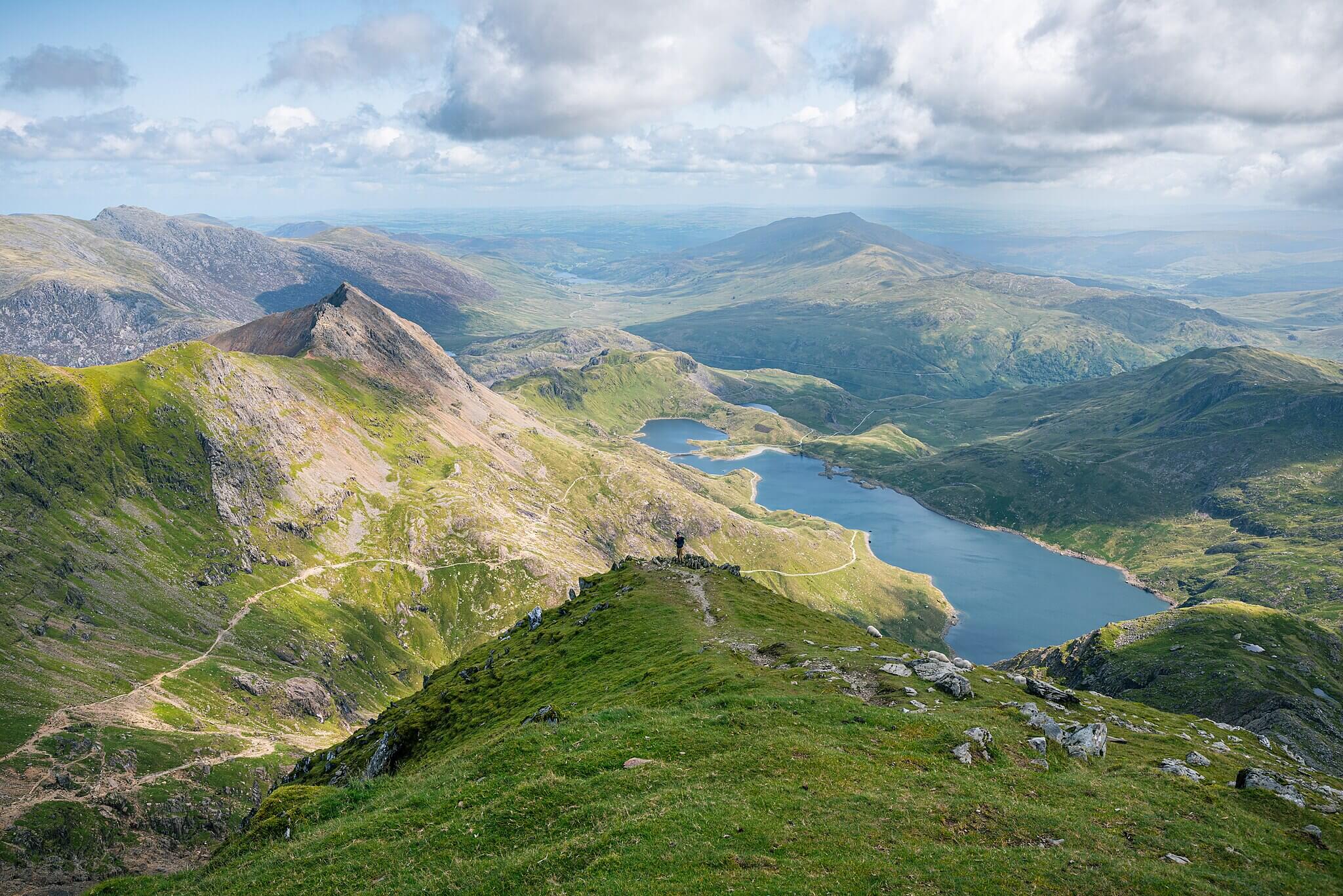
Yr Wyddfa (Snowdon) reaches 1,085 m and the Llanberis Path is the most accessible and reliably waymarked route to its summit, making it the natural choice for dogs and their owners. The path begins in Llanberis near the Snowdon Mountain Railway station and climbs steadily for 14.5 km return, passing the Halfway House café before the gradient steepens above Clogwyn Station. The upper section crosses open exposed ridge with the summit visitor centre, Hafod Eryri, at the top. Navigation is straightforward on a clear day, following a wide, well-worn path throughout with altitude gains of around 975 m from start to summit.
For dogs, this is a full-day mountain commitment rather than a casual outing. The air carries a sharp mineral quality on the upper mountain, and the thin peaty soil gives way to bare rock and frost-shattered slate as you climb. There is water from streams in the lower section; the upper mountain is dry. Sheep are present throughout on the lower and middle flanks, so leads are essential until you clear the grazing ground above around 700 m. The summit ridge itself is more open, but the path is narrow and exposed in places, making confident, calm dogs a much better fit than anxious or reactive ones. This walk is best tackled with fit, experienced dogs on a clear, calm day.
Please note: Crib Goch and South Ridge are not dog friendly routes up the mountain, these ridge routes are dangerous and should only be attempted by experienced climbers.
-
Distance: 14.5 km (9 miles)
-
Duration: 6 to 7 hours
-
Difficulty: Challenging
-
Elevation gain: 975 m
-
Walk Type: Peak
-
Route Type: Out and Back
-
Terrain: Well-worn mountain path, rocky and loose in upper section; steep in places
-
Off Lead Potential: Low
-
Livestock Potential: High
-
Parking: Multiple car parks in Llanberis. Snowdon Mountain Railway car park, LL55 4TU area. From £6 (after 3pm) to £11 all day. RingGo app (code 21468) or contactless. Open 6am to 11pm only
-
Facilities: Pen Ceunant café (lower section); Halfway House café (seasonal, approx 5 km from start); Hafod Eryri summit visitor centre; toilets at car parks in Llanberis
Tip: The Llanberis Path is the busiest route on Snowdon and can feel crowded on summer weekends. For a quieter experience, aim for a weekday start before 8am. Dogs must be kept on a lead near the summit area where the mountain railway operates.
Llyn Idwal Circular Walk
Rating: 8/10 – A short, spectacular mountain lake circuit in one of Snowdonia’s most dramatic glacial cwms, with consistently excellent views.
 Llyn Idwal – Photo Credit: loanp1
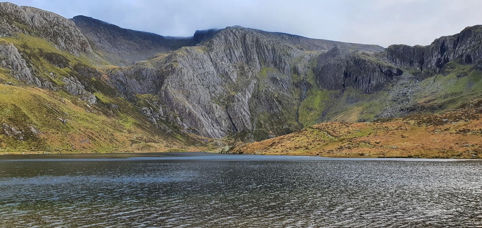
Llyn Idwal sits within Cwm Idwal, a National Nature Reserve in the Ogwen Valley cradled beneath the towering walls of the Glyderau range. The 4.8 km circular route begins from the National Trust car park at Ogwen Cottage and climbs on a well-constructed stone path to the lake, then loops the full perimeter of the water. The south side of the lake passes beneath the dark cliffs of the Devil’s Kitchen (Twll Du) and offers the most dramatic mountain framing anywhere on the circuit. The north side returns on flatter, easier ground with wide views back toward the A5 valley.
For dogs, the walk delivers a powerful mountain experience in a compact distance. The air at Cwm Idwal has a cold, clean quality: the damp scent of bog cotton and wet slate on the approach gives way to the harsher mineral tang of the cliffs as you reach the southern shore. The terrain underfoot is rocky and uneven in places, so dogs should be sure-footed. Swimming is no longer permitted in Llyn Idwal as of 2025, and the National Trust requires dogs to be kept on leads throughout the entire route. This is a non-negotiable restriction, not a precaution, and should be factored in when choosing this walk for a dog that struggles on lead.
-
Distance: 4.8 km (3 miles)
-
Duration: 1.5 to 2 hours
-
Difficulty: Moderate
-
Elevation gain: 100 m
-
Walk Type: Lake, moorland
-
Route Type: Circular
-
Terrain: Stone-pitched path to the lake, rocky and uneven around the perimeter; boggy in wet conditions on the western side
-
Off Lead Potential: Low
-
Livestock Potential: Low
-
Parking: Ogwen Cottage car park, LL57 3LZ. Pay and display: £4 up to 4 hours, £6 all day. Managed by Snowdonia National Park, not National Trust. Free lay-bys available along the A5 (adds approx 15 minutes walking each way)
-
Facilities: Ogwen Cottage visitor centre; Ogwen Snack Bar (open most of year, weekends only in winter); toilets at car park
Tip: The car park at Ogwen Cottage fills very quickly on weekends and bank holidays, often before 9am in summer. The free A5 lay-bys are signed with a P symbol and are a reliable alternative if you arrive late.
Cwm Idwal and Devil’s Kitchen
Rating: 8/10 – An extension of the Llyn Idwal circuit that pushes into genuinely wild high mountain terrain, suitable only for fit and agile dogs.
 Cwm Idwal – Photo Credit: Llywelyn2000
This route builds on the Llyn Idwal circular by continuing beyond the south end of the lake to ascend into the Devil’s Kitchen (Twll Du), the dark cleft in the cliff face that marks the beginning of a demanding climb toward the Glyderau plateau. The extension adds approximately 3.2 km and 300 m of elevation to the lake circuit, taking the total to around 8 km with 400 m of ascent. The path up to the Kitchen is steep, rocky and narrow in its upper section, requiring careful foot placement on loose and sometimes wet stone. On a clear day, the views back down over Llyn Idwal and the Ogwen Valley from the upper section are among the finest in North Wales.
Dogs who handle this extension well need to be fit, confident on steep and uneven ground, and comfortable with exposure. The approach to Twll Du carries the same mineral smell of wet rock as the lower cwm, but the atmosphere becomes more austere as the path narrows and the cliffs close in. There is no swimming access on this route. The National Trust lead requirement from the Llyn Idwal circuit applies throughout: dogs must remain on leads for the entirety of the walk, including the upper ascent. This is a serious mountain environment and not suitable for older dogs or those prone to anxiety in exposed places.
-
Distance: 8 km (5 miles)
-
Duration: 3 to 3.5 hours
-
Difficulty: Challenging
-
Elevation gain: 400 m
-
Walk Type: Lake, moorland, peak
-
Route Type: Circular
-
Terrain: Stone path to the lake, then steep rocky ascent to the Devil’s Kitchen; loose and wet in places at higher elevation
-
Off Lead Potential: Low
-
Livestock Potential: Low
-
Parking: Ogwen Cottage car park, LL57 3LZ. Pay and display: £4 up to 4 hours, £6 all day. Free lay-bys available along the A5
-
Facilities: Ogwen Cottage visitor centre; Ogwen Snack Bar; toilets at car park
Tip: The path into the Devil’s Kitchen is loose and slippery when wet. If you are completing this extension, hiking poles are useful for the steeper sections. Turn back at the lake if conditions have deteriorated since you left the car park: the cwm creates its own weather and the upper section can be in cloud when the valley is clear.
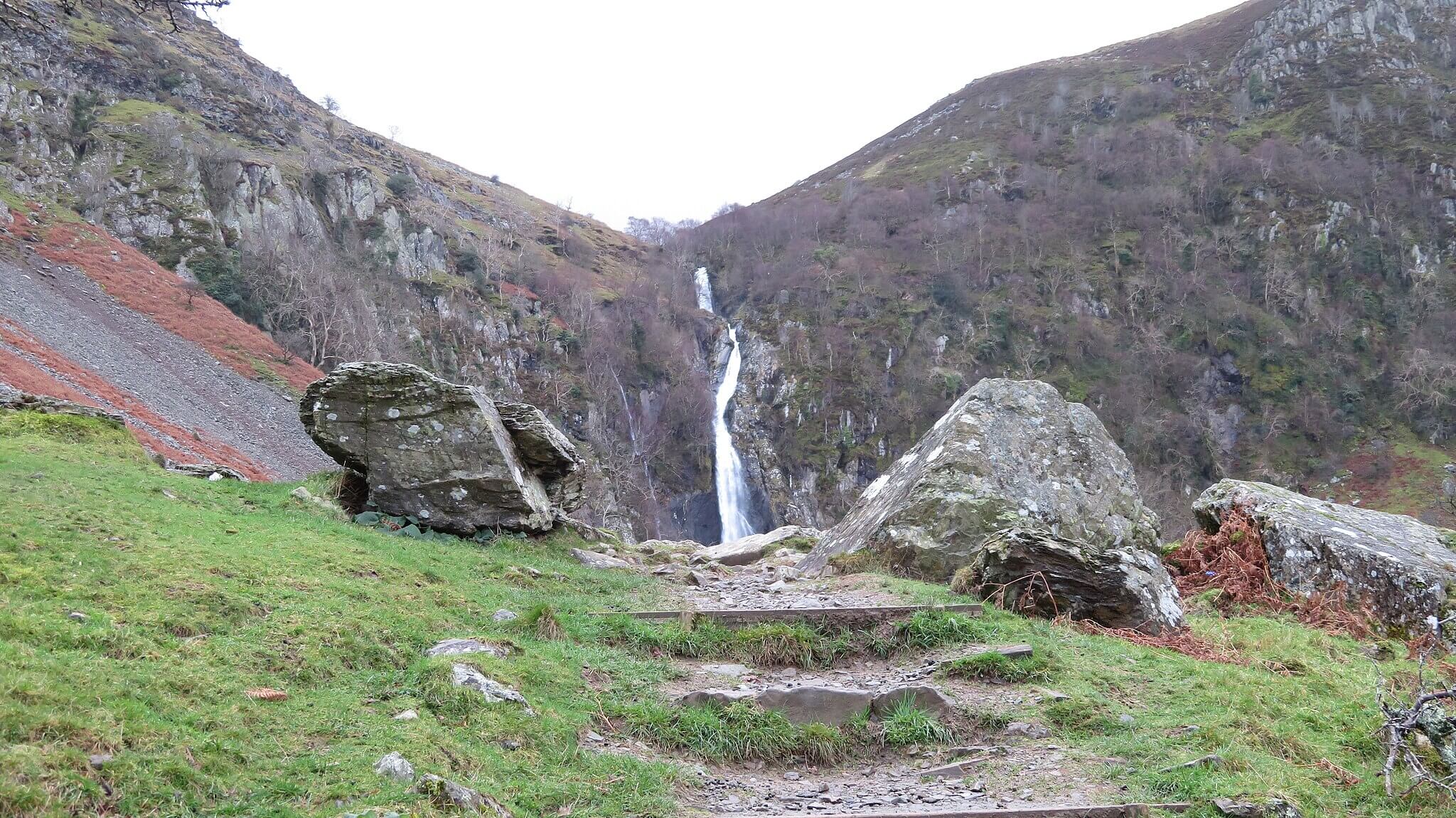
Aber Falls (Rhaeadr Fawr)
Rating: 8/10 – An easy, rewarding waterfall walk through open valley scenery near the northern edge of the park, with wide paths and a spectacular payoff.
 Aber Falls – Photo Credit: Llywelyn2000
Rhaeadr Fawr, meaning Great Waterfall, drops 37 m in a single curtain of white water at the head of the Aber valley near Abergwyngregyn, making it one of the most impressive waterfalls in Wales. The circular route covers 6.5 km from the village car park, following well-maintained wide paths along the valley floor through open grassland and patches of sessile oak, with the valley sides rising steeply on both sides. The waterfall sits at the end of the outward path, and the return leg loops around via higher ground with views back down the valley. The route is well-signed and easy to follow throughout.
For dogs, this is one of Snowdonia’s most accessible and rewarding half-days. The valley air carries the cool, sweet-green smell of upland grass and river water, with woodsmoke from nearby farms drifting through on colder mornings. The Afon Rhaeadr runs alongside much of the route and offers plentiful water access, though the current is fast after rain and care should be taken near the falls. Sheep graze the valley floor and surrounding hillsides, so leads are required throughout most of the route. The wide, firm paths make this a practical choice for larger or older dogs who may struggle on rockier mountain terrain.
-
Distance: 6.5 km (4 miles)
-
Duration: 2 to 2.5 hours
-
Difficulty: Easy
-
Elevation gain: 140 m
-
Walk Type: Waterfall, river
-
Route Type: Circular
-
Terrain: Wide compacted gravel paths and firm moorland tracks; mostly flat with a gentle climb on the return
-
Off Lead Potential: Low
-
Livestock Potential: High
-
Parking: Two small pay and display car parks at the trailhead near Abergwyngregyn, LL33 0LP area. Approximately £5/day, coins or card. Upper car park has toilets. Both fill quickly on weekends; a free car park in the village adds approximately 30 minutes to the walk but avoids the congestion on the single-track approach road
-
Facilities: Toilets at upper car park; no café at the trailhead
Tip: The single-track road through Abergwyngregyn to the upper car parks causes significant congestion on busy weekends. Arriving before 9am or using the village car park avoids the bottleneck and makes for a much calmer start.
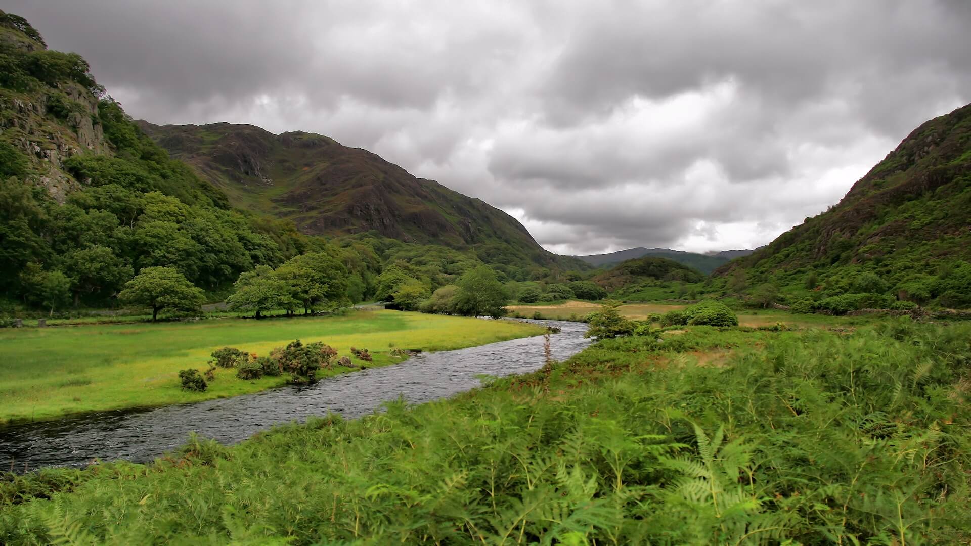
Beddgelert and the River Glaslyn Trail
Rating: 7/10 – A short, charming riverside loop through one of Snowdonia’s most photogenic villages, with gentle terrain and genuine historical interest.
 The River Glaslyn – Photo Credit: Jorge Franganillo
Beddgelert sits at the confluence of the River Glaslyn and the Afon Colwyn in the heart of the Glaslyn valley, surrounded by mountains on all sides. This easy circular walk of around 4 km follows the Glaslyn downstream from the village, crosses a footbridge to visit Gelert’s Grave, said to mark the resting place of Prince Llywelyn the Great’s faithful hound, then loops back through riverside meadows past the old church of St Mary. The paths are well-maintained and almost entirely flat, passing through open grazing land with the river close at hand for most of the route.
For dogs, the walk offers a relaxed mix of riverside sniffing, open meadow and the kind of varied scent landscape that busy tourist villages generate: cut grass, river mud, bakery smells drifting from the village cafés, and the damp green of well-watered valley floor. The Glaslyn offers good access for a paddle in calmer weather, though river levels rise quickly after rain and care should be taken. Dogs should be kept on leads throughout as the route crosses active grazing meadows where sheep and sometimes cattle are present. The walk suits dogs of all ages and sizes, and the short distance makes it an ideal warm-up or recovery day option.
-
Distance: 4 km (2.5 miles)
-
Duration: 1 to 1.5 hours
-
Difficulty: Easy
-
Elevation gain: 30 m
-
Walk Type: River, historic
-
Route Type: Circular
-
Terrain: Firm riverside paths, some meadow grass; flat throughout
-
Off Lead Potential: Low
-
Livestock Potential: High
-
Parking: Gwynedd Council pay and display car park, Beddgelert, LL55 4YW. Pay and display
-
Facilities: Multiple cafés, pubs and shops in Beddgelert village; public toilets in the village centre
Tip: The legend of Gelert is widely believed to have been invented by a 18th-century innkeeper to attract visitors. The grave itself is a modest stone marker in a riverside meadow, but the walk and village more than justify the trip on their own merits.
Llyn Dinas Circular
Rating: 7/10 – A peaceful and atmospheric lakeside loop close to Beddgelert, set beneath dramatic mountain skylines with good dog access to the water.
 Photo Credit: Peter Bond
Llyn Dinas occupies the floor of the Nant Gwynant valley, flanked by steep hillsides rising toward the Snowdon massif on one side and the moorland above Beddgelert on the other. The 4.5 km circuit follows the lake’s shores on both sides, starting from the small car park at the southeastern end of the lake and looping around via the farm at Llyndy Isaf, now managed by the National Trust. The path has been improved in recent years and the southern shore in particular runs on a well-surfaced, easy-to-follow track that forms part of the developing Lon Gwynant long-distance route. The route passes Dinas Emrys, the hillfort where, according to legend, Vortigern witnessed the battle of the red and white dragons, later depicted on the Welsh flag.
For dogs, this is a lakeside walk with character and calm. The air in the Nant Gwynant valley has a cool, grassy sweetness in summer, undercut by the mineral edge of the lake itself and the faint earthy richness of National Trust pasture management. Llyn Dinas is shallow and accessible, and dogs can enter the water at several points along the shore. Grazing cattle are managed on the Llyndy Isaf estate from early summer, so leads are required throughout, and care should be taken near the herd if calves are present. The route is suited to dogs of all sizes and ages.
-
Distance: 4.5 km (2.8 miles)
-
Duration: 1.5 hours
-
Difficulty: Easy
-
Elevation gain: 50 m
-
Walk Type: Lake
-
Route Type: Circular
-
Terrain: Well-surfaced gravel track on the south shore; rougher grass and stone path on the north side; mostly flat
-
Off Lead Potential: Low
-
Livestock Potential: High
-
Parking: Small roadside car park at the southeastern end of Llyn Dinas, off the A498 near Beddgelert, LL55 4NG area. Limited spaces; additional roadside parking along the A498
-
Facilities: No facilities at the trailhead; Caffi Gwynant at Nant Gwynant, approximately 1 km north (dog-friendly outdoor seating)
Tip: Caffi Gwynant at the northern end of the valley is an excellent stop before or after the walk. It serves locally-sourced food with an outdoor canopy that is dog-friendly. The postcode for the café is LL55 4NH.
Cader Idris via the Minffordd Path
Rating: 9/10 – One of Wales’ great mountain walks: steep, dramatic and rewarding, with a glacial lake at its heart and sweeping views on a clear day.
 Cader Idris– Photo Credit: Anthony Parkes
Cadair Idris stands at 893 m at the southern end of Snowdonia, and the Minffordd Path is the shortest and most dramatic route to its summit. The walk begins from the Dôl Idris car park off the A487, following a well-signed path that climbs steeply through ancient oak woodland on the Nant Cadair gorge before emerging into the high cwm that holds Llyn Cau, one of Wales’ deepest lakes. From here the path ascends to Craig Cwm Amarch and then the main summit of Penygadair, completing a 9.6 km circular route via Mynydd Moel on the return. The path is well-constructed throughout but the ascent is relentless, with over 788 m of elevation gain making this a serious undertaking.
For dogs, the Minffordd Path is a demanding outing that rewards confident, fit mountain dogs. The gorge section carries the cool, mossy smell of sheltered upland woodland, sharpening to the raw mineral scent of exposed rock and thin mountain soil as you emerge above the trees. Llyn Cau offers wild swimming for dogs willing to brave glacially cold water. Sheep are present on the approach and on the mountain flanks, requiring leads until you reach the higher ground above the cwm. The rocky ascent to Craig Cwm Amarch is steep and requires sure-footedness: this is not a walk for dogs with joint issues or limited mountain experience.
-
Distance: 9.6 km (6 miles)
-
Duration: 5 to 6 hours
-
Difficulty: Challenging
-
Elevation gain: 788 m
-
Walk Type: Peak, lake
-
Route Type: Circular
-
Terrain: Woodland path, stone steps, steep rocky ascent; exposed and loose on upper ridge
-
Off Lead Potential: Low
-
Livestock Potential: High
-
Parking: Dôl Idris car park, off A487 near Minffordd, LL36 9AJ. Pay and display: £3 up to 4 hours, £6 all day (card only). Can fill on peak summer weekends
-
Facilities: Small seasonal café a few minutes into the walk from the car park; toilets at the car park
Tip: Water is scarce above Llyn Cau. Bring sufficient water for your dog for the upper section of the route. The descent from the summit via Mynydd Moel is steep and hard on joints in both directions; trekking poles are strongly recommended for the human member of the team.
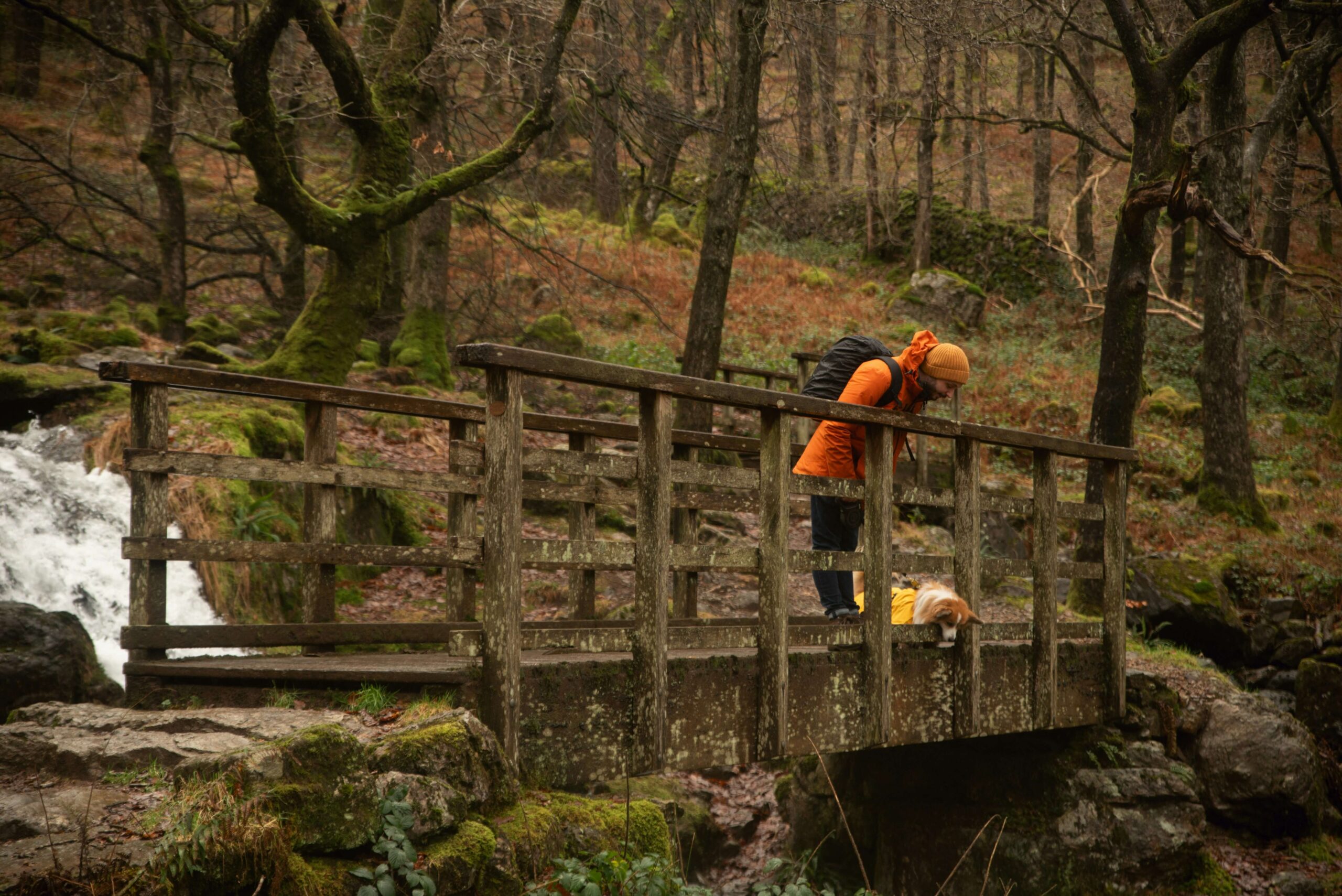
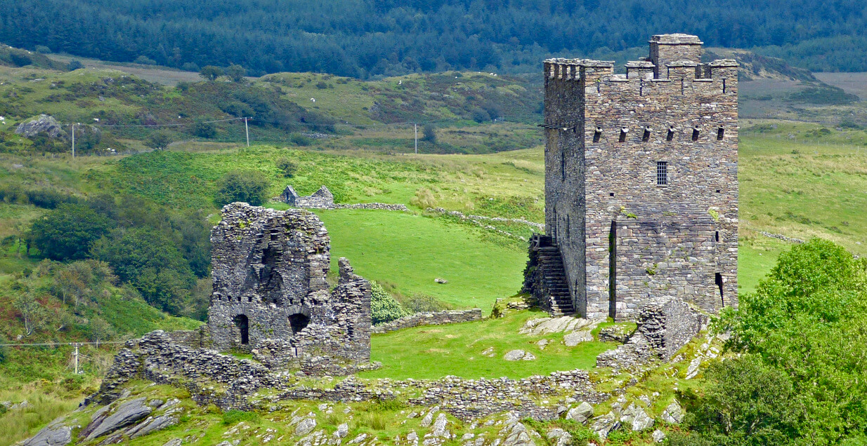
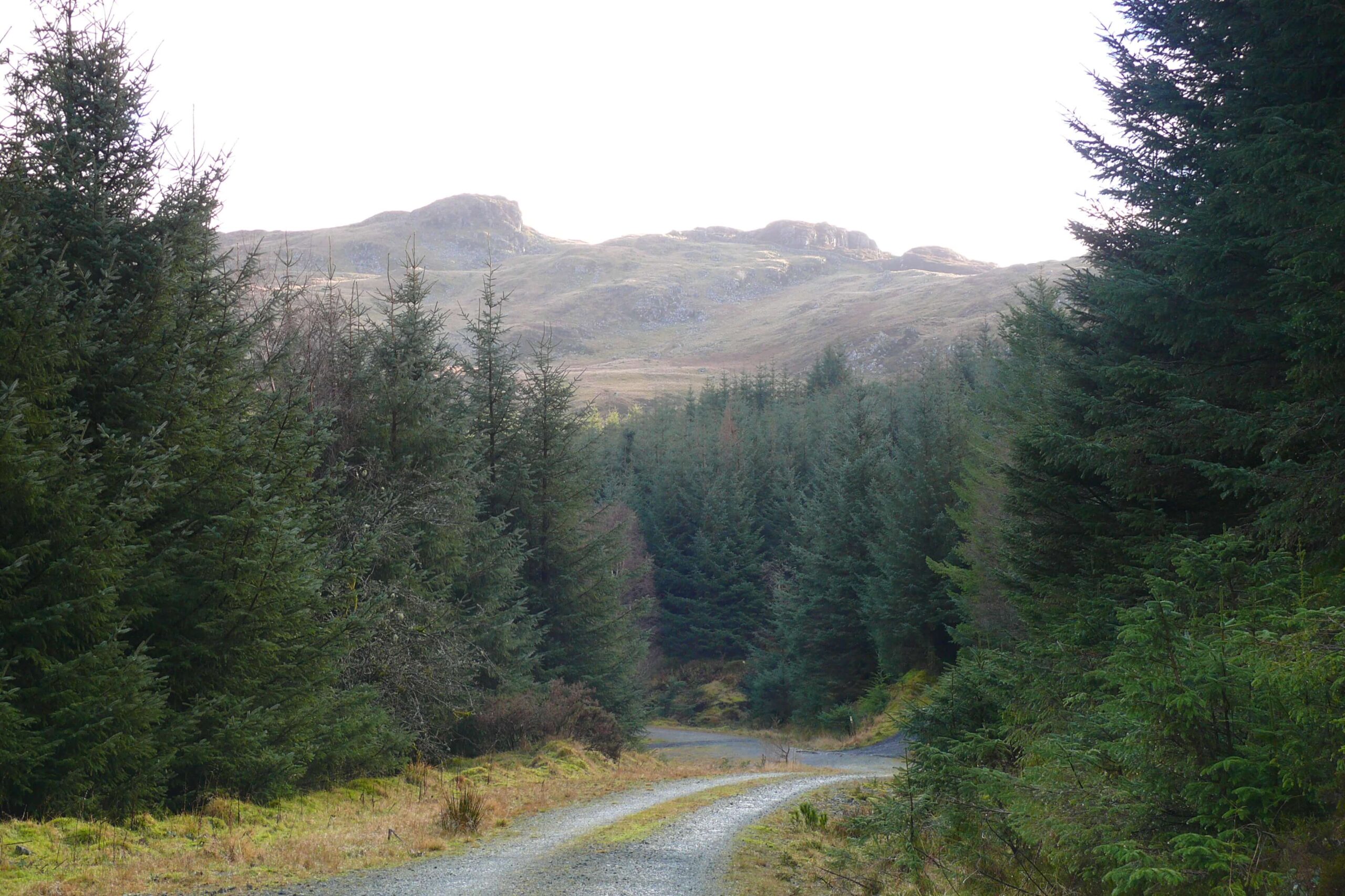
Dolwyddelan Castle and Moel Siabod Viewpoint
Rating: 7/10 – A quiet, underrated loop from a historic village combining medieval ruins, forest tracks and commanding views toward Moel Siabod.
 Dolwyddelan Castle – Photo Credit: Andrew
This circular walk starts from Dolwyddelan railway station car park in the village of Dolwyddelan and follows a waymarked route developed by Natural Resources Wales as part of the Gwydir Forest Park trail network. The route climbs from the valley floor, following part of the ancient Sarn Helen Roman road before descending to the river and returning via the valley bottom. Dolwyddelan Castle, built by Llywelyn the Great in the early 13th century and later taken by Edward I in 1283, sits on a prominent knoll above the village and provides the walk’s most dramatic viewpoint. Moel Siabod rises directly to the north, and its full pyramid profile is best seen from the upper section of the route. The loop covers approximately 6.5 km of mixed forest and open ground.
For dogs, this is one of Snowdonia’s quieter and more rewarding valley walks. The lower section through the forest carries the resinous scent of conifer and damp leaf litter, opening to the sweeter, bracken-and-heather smell of open hill as the path climbs above the tree line. There is access to the Afon Lledr in the valley section. Sheep graze the open ground above the village, so leads are required for the hillside sections. The forest tracks are broad and well-surfaced, making this a practical choice on a day when the high peaks are in cloud.
-
Distance: 6.5 km (4 miles)
-
Duration: 2 to 2.5 hours
-
Difficulty: Moderate
-
Elevation gain: 220 m
-
Walk Type: Historic, woodland, moorland
-
Route Type: Circular T
-
errain: Mix of forest road, open moorland path and valley track; one steeper section on the hillside climb
-
Off Lead Potential: Moderate
-
Livestock Potential: Moderate
-
Parking: Dolwyddelan railway station car park, LL25 0SZ. Small community-managed car park; parking charge applies
-
Facilities: Y Gwydyr pub in the village (LL25 0EJ) for post-walk food; no facilities at the trailhead
Tip: Dolwyddelan has its own station on the Conwy Valley line between Llandudno Junction and Blaenau Ffestiniog, making this one of the few walks in Snowdonia that is genuinely accessible by train. Check Traveline Cymru for timetables, particularly if visiting at weekends when services are reduced.
Coed y Brenin Forest Park — Gain Waterfall Trail
Rating: 8/10 – A rewarding forest walk through the heart of Wales’ most celebrated trail park, finishing at twin waterfalls deep in the Mawddach valley.
 Coed y Brenin Forest Park – Photo Credit: Ian Medcalf
The Gain Waterfall Trail is the flagship walking route at Coed y Brenin, covering 6.6 km of forest road and narrow path through the southern reaches of Eryri National Park near Dolgellau. The route starts from the main visitor centre car park and climbs over the Cefndeuddwr ridge before dropping into the next valley to reach the confluence of the Afon Gain and Afon Mawddach, where the two rivers meet in a series of waterfalls in a sheltered wooded gorge. The descent to the falls is steep and the path narrows considerably, but the reward is one of the quieter and more dramatic waterfall settings in Snowdonia. The return leg retraces the ridge before descending back to the visitor centre.
For dogs, Coed y Brenin offers one of the most consistently enjoyable walking environments in the national park. The forest carries a deep, resinous smell of mature conifers that shifts to the fresher mineral scent of the rivers as you descend toward the gorge. Both the Afon Gain and Afon Mawddach offer excellent water access, and the trails are largely free of livestock, giving genuinely good off-lead potential on the forest sections. The steeper, narrower path down to the falls requires dogs to be managed carefully, particularly on the descent where loose surface and unprotected drops into the river gorges demand caution. This walk suits confident dogs of most ages and sizes.
-
Distance: 6.6 km (4.1 miles)
-
Duration: 2.5 to 3 hours
-
Difficulty: Moderate
-
Elevation gain: 200 m
-
Walk Type: Forest, waterfall, river
-
Route Type: Circular
-
Terrain: Forest road and gravel path on the upper section; steep narrow path with uneven and sometimes muddy ground on the descent to the falls
-
Off Lead Potential: High
-
Livestock Potential: Low
-
Parking: Coed y Brenin Visitor Centre, LL40 2HZ. Pay and display: up to 1 hour £1, up to 3 hours £3, all day £5. Free for Blue Badge holders and local LL40/LL41 residents with V5 log book
-
Facilities: Visitor centre; café (seasonal hours, check before visiting); bike shop (Beics Brenin); toilets; picnic benches; play area
Tip: The path near the waterfalls passes old mine workings and buildings that may be unsafe, with unprotected drops into the river gorges. Keep dogs close and on lead for this section regardless of how well-behaved they are on the wider forest trails.
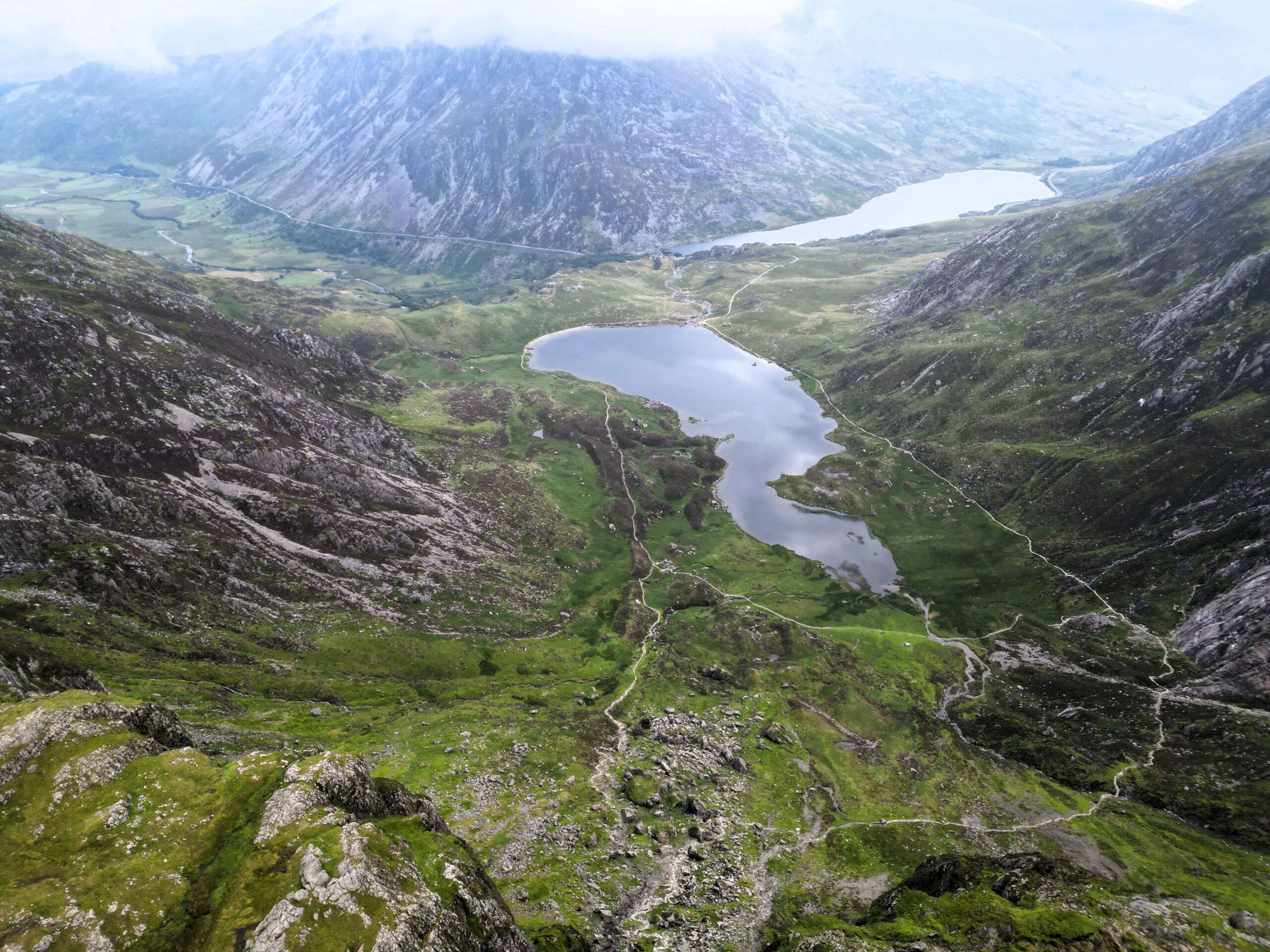
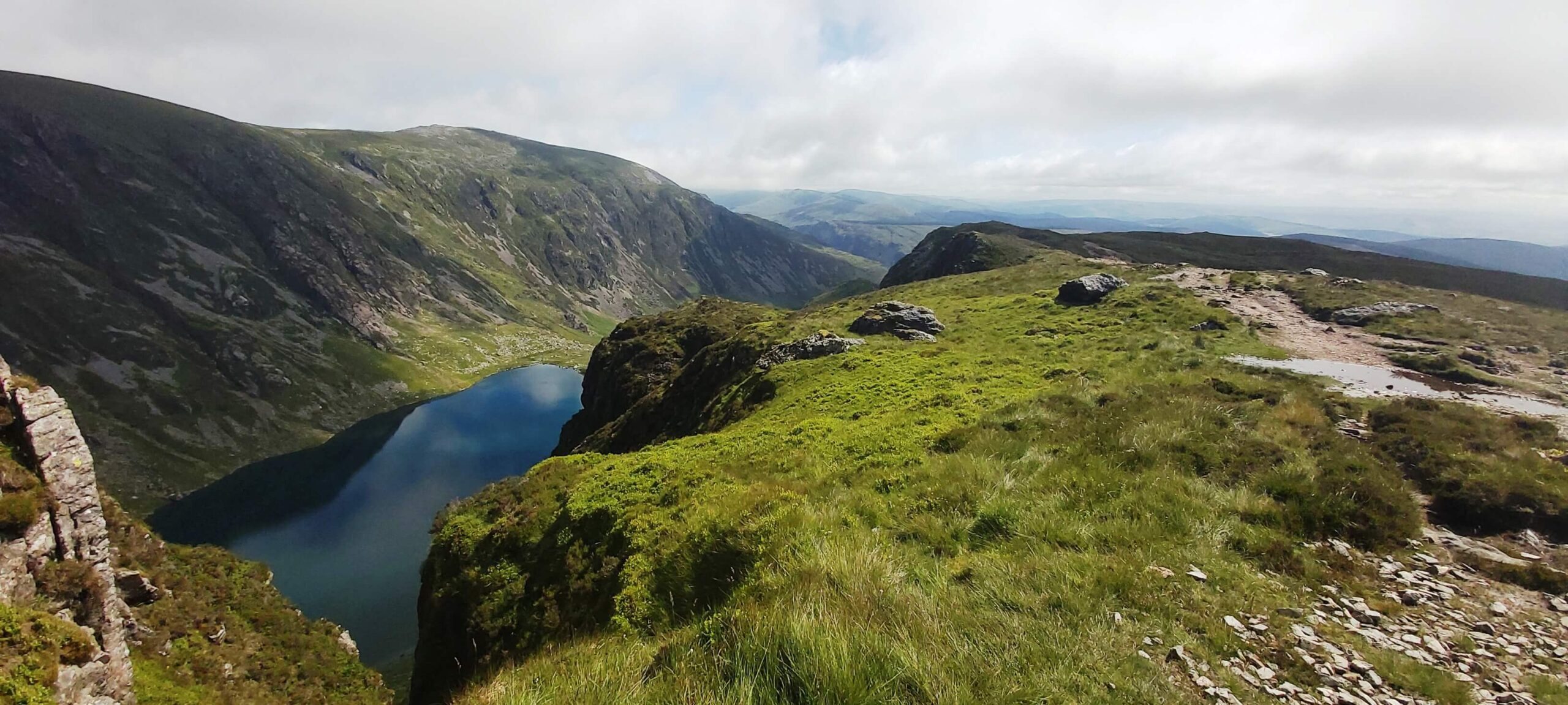
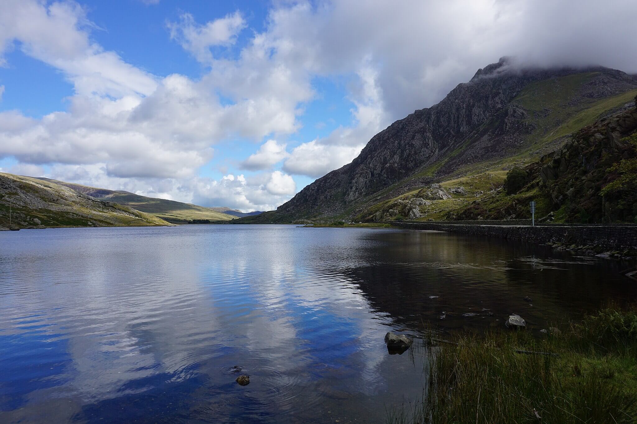
Llyn Ogwen to Tryfan Viewpoint
Rating: 8/10 – A short, spectacular lakeside circuit in the Ogwen Valley with some of the best views of Tryfan’s iconic north face available without a full mountain climb.
 Llyn Ogwen – Photo Credit: Bill Boaden
Llyn Ogwen sits alongside the A5 at the foot of the Glyderau range, flanked to the south by the instantly recognisable pyramid shape of Tryfan (917 m) and to the north by the broad slopes of the Carneddau. This 4.6 km circular walk follows the southern shore of the lake on a rougher, bouldery path with outstanding mountain views before returning along the northern side on easier ground. The Ogwen Falls at the western end of the lake add a further point of interest, and the walk can be extended toward Llyn Idwal with minimal additional effort. The route requires some scrambling over boulders at the start but settles into a straightforward lakeside path after the first few hundred metres.
For dogs, the walk packs exceptional mountain scenery into a compact distance. The air at Llyn Ogwen is bracing and clear, with the cold, clean smell of open water and the faint peatiness of the surrounding bog. The lake itself is large and accessible, and dogs can enter the water at several points along the northern shore. Dogs must be kept on leads throughout: the National Trust requires this for all dogs in this area, and the boulder-field section at the start requires careful management. The rocky terrain and loose ground make this a walk suited to confident, sure-footed dogs rather than puppies or older dogs with mobility limitations.
-
Distance: 4.6 km (2.9 miles)
-
Duration: 2 hours
-
Difficulty: Moderate
-
Elevation gain: 80 m
-
Walk Type: Lake, moorland
-
Route Type: Circular
-
Terrain: Bouldery path on the south shore; easier gravel and grass on the north; wet and boggy in places especially in winter
-
Off Lead Potential: Low
-
Livestock Potential: Low
-
Parking: Ogwen Cottage car park (also serves Llyn Idwal), LL57 3LZ. Pay and display: £4 up to 4 hours, £6 all day. Free lay-bys available along the A5
-
Facilities: Ogwen Snack Bar at the western end of the lake; toilets at Ogwen Cottage
Tip: The first section of the south shore path involves clambering over large boulders and can be very wet in winter. If this section is flagged as impassable, the walk can be reversed from the north shore path with no loss of the best Tryfan views.
Tips for Walking in Snowdonia with Your Dog
- Livestock is everywhere: Sheep farming is the backbone of the Eryri landscape, and virtually every valley and hillside route passes through working farmland at some point. A dog that cannot be reliably recalled should be kept on a lead at all times, not only during grazing season.
- River levels change fast: Snowdonia has some of the highest annual rainfall in England and Wales. The Glaslyn, Afon Llugwy and other rivers can rise from paddling depth to dangerous within hours of heavy rainfall. Check river conditions and avoid crossing points if there has been significant rain in the previous 24 hours.
- Mountain weather moves quickly: Summit routes on Snowdon, Cadair Idris and Moel Siabod can be in dense cloud while the valley floor is clear and sunny. Carry a waterproof layer for your dog, check the mountain weather forecast separately from the general weather, and be prepared to turn back if visibility drops.
- Car parks fill early: The most popular trailheads, including Ogwen Cottage, Llanberis and the Minffordd Path car park, regularly fill before 9am on summer weekends and bank holidays. Plan an early start or use alternative parking where it is available.
- Adders are present in summer: Adders are found on heathland and moorland throughout Snowdonia and are most active between April and September. Keep dogs away from bracken and long grass where possible, and know the signs of adder bite: swelling, lethargy and distress. Veterinary care should be sought immediately if a bite is suspected.
- The nesting season affects open ground: Between March and July, ground-nesting birds including curlew and lapwing use the upland moorland and grassland. Keep dogs under close control on open ground during this period to avoid disturbing nests.
Map of Dog Friendly Snowdonia Walks
- Mount Snowdon (via Llanberis Path)
- Llyn Idwal (Circular)
- Cwm Idwal and Devil's Kitchen
- Aber Falls (Rhaeadr Fawr)
- Beddgelert and River Glaslyn Trail
- Llyn Dinas (Circular)
- Cader Idris via Minffordd Path
- Dolwyddelan Castle & Moel Siabod Viewpoint
- Coed y Brenin Forest Park
- Llyn Ogwen to Tryfan Viewpoint
- Coed y Brenin Forest Park — Gain Waterfall Trail
- Dolwyddelan Castle and Moel Siabod Viewpoint
Now you know the top 10 dog walks and hikes in Snowdonia National Park, you will of course want to know where to find them! Our handy map below can direct you to each of these wonderful walks and hikes. Simply choose the one you want and get directions to the nearest car park.
Explore more dog friendly locations, including hikes, campsites and road trips on our Wildpack Map, our curated and ever growing map of locations to explore with your dog.
What’s Nearby?
If you’re extending your trip or planning multiple days in the area, Snowdonia sits within easy reach of some excellent dog friendly adventures across North Wales and beyond:
- Dog friendly walks in North Wales – Coastal paths, forest trails and quieter mountain routes that pair perfectly with a Snowdonia base.
- Dog friendly beaches in the Llyn Peninsula – Ideal for recovery days, sea air and space to let dogs roam after tougher hikes.
- Dog friendly campsites in Snowdonia **–**Make the most of your trip and book a dog friendly campsite in the heart of Snowdonia.
- **Snowdonia and Llyn Peninsula Road Trip –**Undertake a scenic road trip with your pup and explore the national park and beaches of the Llyn Peninsula.
- Dog friendly walks in the Brecon Beacons – Head South for even more dog friendly walks in the Brecon Beacons National Park.
- Dog friendly beaches in Anglesey – Wilder and less crowded than Snowdonia, with coastal paths and rural walks.
- Dog friendly walks in Anglesey – Explore stunning trails both inland and on the coast on the Isle of Anglesey.
- Dog friendly beaches in Ceredigion – Wide sands, estuaries and quieter coastal stretches
These nearby guides make it easy to build a longer, more varied dog friendly trip across North Wales without repeating the same landscapes day after day.