
The Peak District is one of the finest places in England to walk with a dog. From the dark, peat-black moorland of the High Peak to the pale limestone dales of the White Peak, the variety here is extraordinary: open fell ridges with 360-degree views, ancient oak gorges, glittering reservoirs, and river valleys where your dog can swim in clear water. Whether you’re after a short scramble above a Hope Valley village or a full day on the high plateau, the national park has a route for it.
In this guide we’ve pulled together the best dog friendly walks across the Peak District, covering every corner of the national park. Routes run from flat, accessible towpaths to challenging moorland circuits, with a genuine mix of terrain, scenery, and off-lead opportunity throughout. Each walk has been chosen for its clear starting point, reliable paths, and quality of the experience for dogs and owners alike.
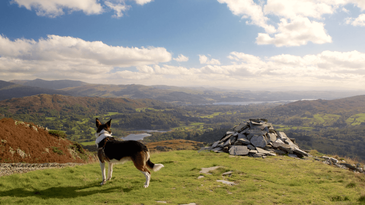
Mam Tor and the Great Ridge from Castleton
Rating: 9/10 — One of the finest ridge walks in England, combining an iconic summit, sweeping views in every direction, and excellent accessibility for most dogs.
 Mam Tor – Photo Credit: Tony Kirwan
Mam Tor rises to 517 metres above the Hope Valley, its summit crowned with the visible earthworks of a late Bronze Age hill fort. This classic circular from Castleton ascends via the cave-studded hillside past Treak Cliff and Blue John Cavern, climbing to the ridge at Mam Tor via a well-maintained series of stone steps. From the summit the route follows the Great Ridge northeast along three kilometres of flagstone path, passing Hollins Cross and Back Tor before reaching Lose Hill. The descent drops into Castleton through Cave Dale, a spectacular limestone gorge carved by glacial meltwater, passing directly beneath Peveril Castle. The full circuit is 13 km and takes four to five hours at a comfortable pace.
The ridge offers one of the most rewarding experiences in the Peak District for active dogs. The scent of heather and sun-warmed gritstone carries strongly across the exposed flagstone path, and the breezes that sweep both sides of the ridge keep most dogs alert and engaged throughout. The upper ridge is largely off-lead territory, though leads are needed on the lower slopes approaching Castleton where sheep graze unfenced ground. There is no reliable water on the ridge itself, so carry enough for the climb; the stream at the base of Cave Dale provides a drink on the way back. Dogs should be moderately fit for this walk due to the initial climb and length.
-
Distance: 13 km (8.1 miles)
-
Duration: 4 to 5 hrs
-
Difficulty: Moderate
-
Elevation gain: 500 m
-
Walk Type: Peak, Moorland
-
Route Type: Circular
-
Terrain: Stone steps on ascent, flagstone ridge path, loose limestone on Cave Dale descent, field paths on approach
-
Off Lead Potential: Moderate
-
Livestock Potential: Moderate
-
Parking: Mam Nick Car Park, S33 8WA (National Trust, pay and display or free for NT members); also Castleton Visitor Centre Car Park
-
Facilities: Cafés, pubs, and toilets in Castleton at walk start and finish; no facilities on route
Tip: The ridge between Mam Tor and Hollins Cross catches the wind hard on exposed days, so factor that in if you have a smaller or fine-coated dog.
Kinder Scout from Edale
Rating: 8/10 — The Peak District’s highest point delivers stunning moorland drama, though demanding terrain and mandatory leads near livestock make it best suited to experienced dogs.
 View from Kinder Scout – Photo Credit: Andrew Bone
Kinder Scout is the High Peak in its rawest form. This circular route starts in Edale village at the official beginning of the Pennine Way, ascending via the rocky ravine of Grindsbrook Clough onto the Kinder Plateau at 636 metres. The route follows the edge of the plateau past Crowden Tower, the Woolpacks rock formations, and the Noe Stool, before descending via Jacob’s Ladder — a series of pitched stone steps beside the River Noe — and returning to Edale on the final section of the Pennine Way. The total circuit covers approximately 12.7 km and takes five to six hours; the plateau section requires navigation skills in poor weather and should not be attempted in low cloud.
Dogs find this a deeply absorbing walk, with the sharp mineral scent of dark peat and wet heather carrying across the open plateau on most days. The ascent through Grindsbrook Clough involves a grade-one scramble over gritstone boulders — manageable for most dogs, though assistance may be needed at the steepest section. Leads are required near livestock on the lower farmland sections around Upper Booth; the plateau itself is open access land with no stock. Water is plentiful from streams throughout, including the River Noe at the base of Jacob’s Ladder for a cool-down at the end. This is a walk for confident, fit dogs and their owners.
-
Distance: 12.7 km (7.9 miles)
-
Duration: 5 to 6 hrs
-
Difficulty: Challenging
-
Elevation gain: 535 m
-
Walk Type: Moorland, peak
-
Route Type: Circular
-
Terrain: Steep rocky ravine on ascent, exposed peat moorland on plateau, flagstone path on descent, farmland tracks
-
Off Lead Potential: Moderate
-
Livestock Potential: Moderate
-
Parking: Edale Car Park, S33 7ZQ. Pay and display, cash or PayByPhone; busy at weekends
-
Facilities: The Old Nag’s Head pub at walk start and finish; toilets in Edale village
Padley Gorge and Longshaw Estate
Rating: 9/10 — Ancient sessile oak woodland, cascading stream pools, and the broad open heathland of Longshaw combine to make this one of the most complete short circuits in the Peak District.

Padley Gorge is a narrow, moss-covered valley cut by the Burbage Brook through gritstone bedrock, carpeted in ancient sessile oak and birch that give the place an almost mythological atmosphere. This circular starts from the Longshaw Estate car park, crossing the open heathland of the estate before descending into the gorge for a streamside walk among the boulders and small waterfalls of the brook. The route exits the gorge at Grindleford Station, passing the famous station café, before climbing back through woodland to return across the Longshaw Estate. The circuit covers approximately 7 km and takes around two hours at a comfortable pace, though allowing more time is strongly recommended. Pied flycatchers nest in the gorge in spring and summer, making it one of the finest birdwatching walks in the national park.
The dog experience here is outstanding. The Burbage Brook runs reliably throughout the year, offering wade-in access at multiple points along the gorge floor, and the scent of ancient oakwood, wet moss, and stream-cold stone makes this one of the most stimulating routes in this guide. Leads are required across the Longshaw Estate sections where cattle graze the open heath; once in the gorge itself, dogs can move more freely along the brook. The rocky terrain in the deeper gorge sections requires some care on steep-sided banks, so confident, sure-footed dogs get the most out of this walk. Longshaw café is open daily and welcomes dogs at outdoor seating.
-
Distance: 7 km (4.3 miles)
-
Duration: 2 to 2.5 hrs
-
Difficulty: Moderate
-
Elevation gain: 180 m
-
Walk Type: Woodland, river
-
Route Type: Circular
-
Terrain: Open estate paths, rocky streamside woodland, some steep gorge sections; muddy in wet weather
-
Off Lead Potential: Moderate
-
Livestock Potential: Moderate
-
Parking: Longshaw Estate Woodcroft Car Park, S11 7TZ. National Trust, pay and display or free for members; also free roadside bays on B6521
-
Facilities: Longshaw café at car park (daily); Grindleford Station café midway; toilets at both
Tip: The gorge can be slippery after rain, so good boots (and a towel for your dog) are a must.
Stanage Edge from Hollin Bank
Rating: 8/10 — A spectacular gritstone escarpment with wide moorland views and a surprisingly accessible walk that suits dogs of most fitness levels.
 The Millstones at Stanage Edge – Photo Credit: Neil Theasby
Stanage Edge is the defining gritstone escarpment of the Dark Peak, stretching for over five kilometres along a ridge above Hathersage. This circular route starts from Hollin Bank car park below the escarpment, climbing a short wooded path to reach the top of the edge near High Neb, the highest point at 458 metres. The walk follows the broad ridge path south along the full length of the edge, passing abandoned millstones, wind-carved boulder formations, and Robin Hood’s Cave before descending beneath the crags and looping back across open moorland to the car park. The route covers around 9 km and takes two and a half to three hours. The escarpment is famously recognisable as a filming location from the 2005 adaptation of Pride and Prejudice.
For dogs the edge is excellent: the largely level ridge path allows free movement across open gritstone and heather, and the scent of dry-baked rock and bilberry on a summer day draws them along the full length of the escarpment. There are no formal lead requirements on the open access land of the edge itself, but leads are sensible at the car park approach and on any sections where rock climbers are active below the crag face. Water is scarce on the ridge, so carry plenty for warm-weather visits. The Scotsmans Pack pub in nearby Hathersage is famously welcoming to dogs and a natural end-of-walk destination.
-
Distance: 9 km (5.6 miles)
-
Duration: 2.5 to 3 hrs
-
Difficulty: Moderate
-
Elevation gain: 217 m
-
Walk Type: Moorland, historic
-
Route Type: Circular
-
Terrain: Wooded path on ascent, gritstone and heather ridge path, moorland track on return
-
Off Lead Potential: High
-
Livestock Potential: Low
-
Parking: Hollin Bank Car Park, S32 1BR. Pay and display, £4.75 all day; toilets 150 m from car park entrance
-
Facilities: Public toilets at car park; cafés and pubs in Hathersage, a short drive away
Tip: There’s little shade or water here, so bring extra for your pup — especially on sunny days.
Dovedale Stepping Stones and Thorpe Cloud
Rating: 7/10 — The most iconic short walk in the White Peak, combining the famous limestone stepping stones, a surprisingly dramatic summit, and a river valley of genuine beauty.
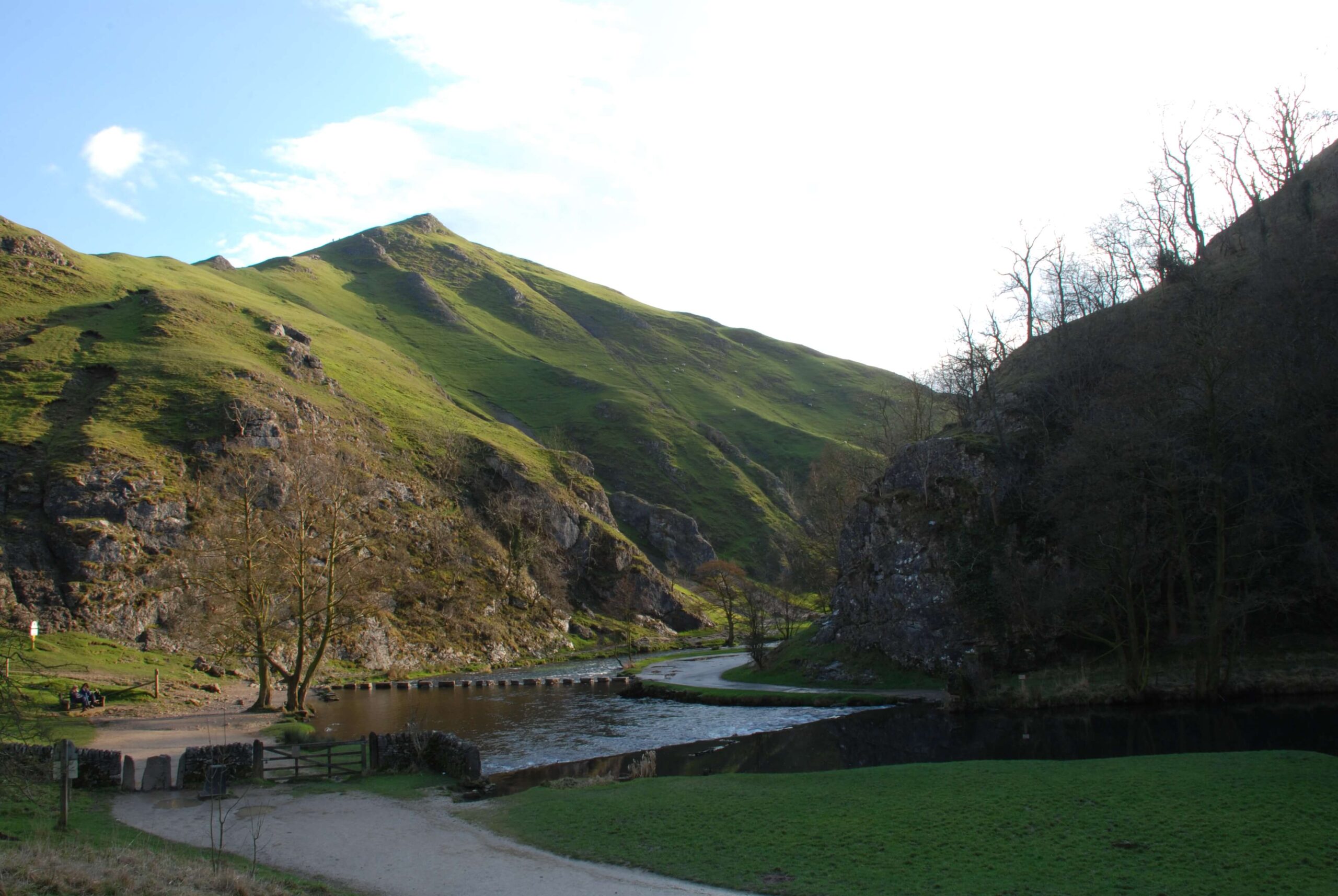 Dovedale Stepping Stones – Photo Credit: Rob Bendall
Dovedale is one of the most visited valleys in the Peak District, and its 16 limestone stepping stones across the River Dove have drawn visitors since the Victorian era. This compact circular from the Dovedale car park follows the valley floor north to the stepping stones, crosses to the western bank, circles over Thorpe Cloud (287 metres) with its views across the White Peak, then descends back along the river. The Dove Valley is a National Nature Reserve, managed for rare habitats and rich invertebrate life.
Dogs must be on leads throughout due to the NNR designation and grazing livestock, but the river air along the valley floor carries a complex mix of watercress, chalk stone, and cool water that dogs find deeply absorbing even on the lead. The stepping stones can be awkward for dogs to cross, and many wade through the shallows beside them instead. Arrive early on summer weekends: the car park fills by 9 am and the stepping stones become very crowded from mid-morning.
-
Distance: 5.5 km (3.4 miles)
-
Duration: 1.5 to 2 hrs
-
Difficulty: Moderate
-
Elevation gain: 242 m
-
Walk Type: River, peak
-
Route Type: Circular
-
Terrain: Flat tarmac path to stepping stones, rocky ascent on Thorpe Cloud, grass and gravel on descent
-
Off Lead Potential: Low
-
Livestock Potential: High
-
Parking: Dovedale Car Park, DE6 2AY. National Trust, pay and display; £4.50 for 4 hours, £6 all day; free for NT members. Fills early on sunny weekends
-
Facilities: Toilets at car park (20p charge); pubs in Thorpe village, 5 minutes by car
Tip: Expect crowds in summer. Visit early or mid-week for a quieter experience, and watch your dog around the river crossings.
Monsal Trail and Ashford in the Water
Rating: 8/10 — A compact White Peak circuit combining the heritage railway trail, riverside meadows, and one of the prettiest limestone villages in Derbyshire.
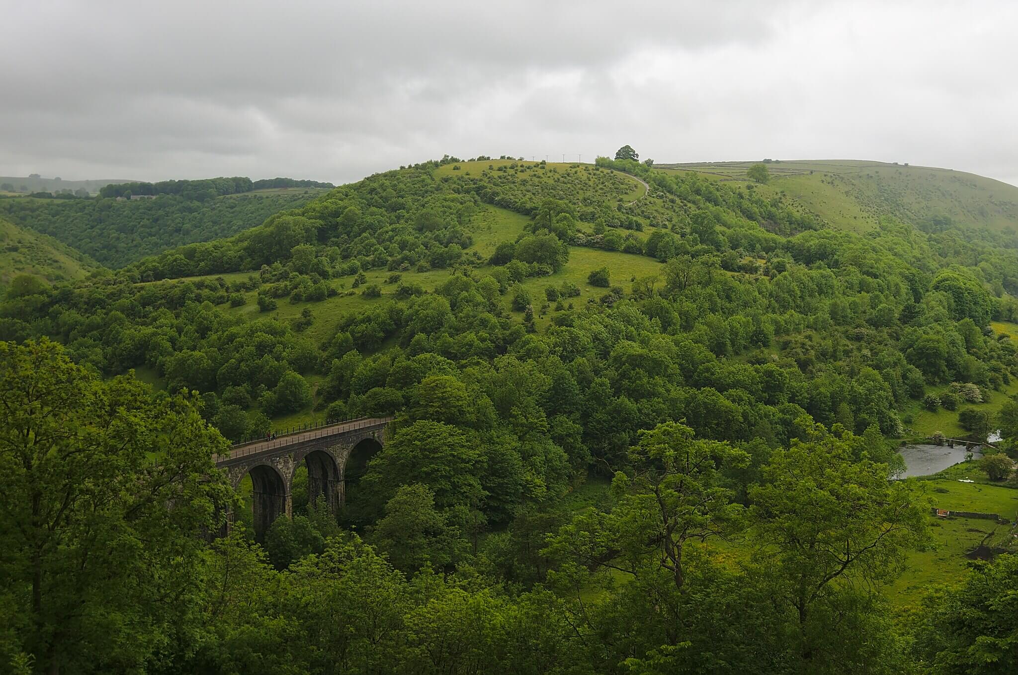 Monsal Trail – Photo Credit: Sketyl none
The Monsal Trail follows the former Midland Railway line through a series of limestone dales, and this circular makes excellent use of a stretch between Bakewell and the village of Ashford in the Water. Starting from Bakewell and heading northwest along the trail, the route passes through two of the restored Victorian tunnels before emerging at Monsal Head with its celebrated view of the Headstone Viaduct curving through the dale below. The return drops down to the River Wye, following the riverside through Shacklow Wood before picking up the quiet lanes into Ashford in the Water, a village of weir bridges, limestone cottages, and a good village shop. The circuit covers approximately 9 km and takes two and a half to three hours. Hassop Station café sits alongside the trail and is a reliable refreshment stop in either direction.
For dogs this is an excellent mid-difficulty walk. The trail surface is firm and smooth enough to be comfortable on paws in all seasons, and the limestone dale sections carry a distinctive cool, chalky freshness on the air that most dogs work hard on. Leads are required through livestock fields on the riverside return and approaching Ashford in the Water, where sheep graze across the water meadows throughout the year. The River Wye provides good water access in several places, with shallow entry points near Shacklow Wood in dry conditions. The trail is shared with cyclists, so leads are sensible in busier sections to avoid encounters at speed.
-
Distance: 9 km (5.6 miles)
-
Duration: 2.5 to 3 hrs
-
Difficulty: Moderate
-
Elevation gain: 265 m
-
Walk Type: River, historic
-
Route Type: Circular
-
Terrain: Firm gravel railway trail, riverside path through woodland, country lanes and field paths on return
-
Off Lead Potential: Moderate
-
Livestock Potential: Moderate
-
Parking: Bakewell Station Car Park, DE45 1BU, or town centre car parks; pay and display
-
Facilities: Hassop Station café on trail; Ashford in the Water village shop mid-route; toilets at Hassop Station
Tip: Bring a long-line lead as you can safely let your dog roam in many sections without worrying about livestock.
Curbar Edge, Froggatt Edge and White Edge
Rating: 8/10 — Three connected gritstone edges, a Bronze Age stone circle, and the chance to spot red deer make this one of the most rewarding moorland circuits in the eastern Peak District.
This circular from Curbar Gap connects three of the Derwent Valley’s finest gritstone escarpments in a single route. The walk heads northeast from the car park across Big Moor to White Edge, following the ridge to its trig point at 365 metres before descending to the Grouse Inn at Froggatt, the natural mid-point for a stop. The return follows Froggatt Edge and then Curbar Edge south, with the views across the Derwent Valley and towards Chatsworth improving steadily as you near the car park. A Bronze Age stone circle sits alongside the path on Froggatt Edge, easy to miss if you are not looking for it. The full circuit covers approximately 9.4 km with around 380 metres of ascent and takes three to three and a half hours. In autumn the deer rut on Big Moor produces extraordinary sounds across the valley.
Dogs generally thrive on this walk: the heather moorland of White Edge offers good off-lead running on firm ground, and the scent of bilberry, heather sap, and damp gritstone is persistently interesting. Leads are needed near any livestock encountered in the fields below the edges and on the short road sections through the villages. The Grouse Inn at Froggatt is dog-friendly and makes a natural halfway break. Water is limited on the high edges, but there are streams below the escarpment near Froggatt village. Parking at Curbar Gap is a small National Trust car park that fills quickly on weekends; arrive early or take your chances on the roadside.
-
Distance: 9.4 km (5.8 miles)
-
Duration: 3 to 3.5 hrs
-
Difficulty: Moderate
-
Elevation gain: 380 m
-
Walk Type: Moorland
-
Route Type: Circular
-
Terrain: Open moorland track, gritstone edge paths, some rocky and uneven sections, short stretches of country lane
-
Off Lead Potential: High
-
Livestock Potential: Moderate
-
Parking: Curbar Gap Car Park, S32 3YR. National Trust, pay and display or free for members; 25 to 30 spaces, fills quickly
-
Facilities: The Grouse Inn at Froggatt (halfway); no toilets on route; coffee van at weekends at Curbar Gap car park
Tip: There are several stiles along the route, so smaller dogs may need a lift over.
Tittesworth Reservoir Trail
Rating: 8/10 — A beautifully managed reservoir circuit on the Staffordshire edge of the Peak District, combining woodland trails, waterside paths, and a dramatic backdrop of the Roaches and Hen Cloud.
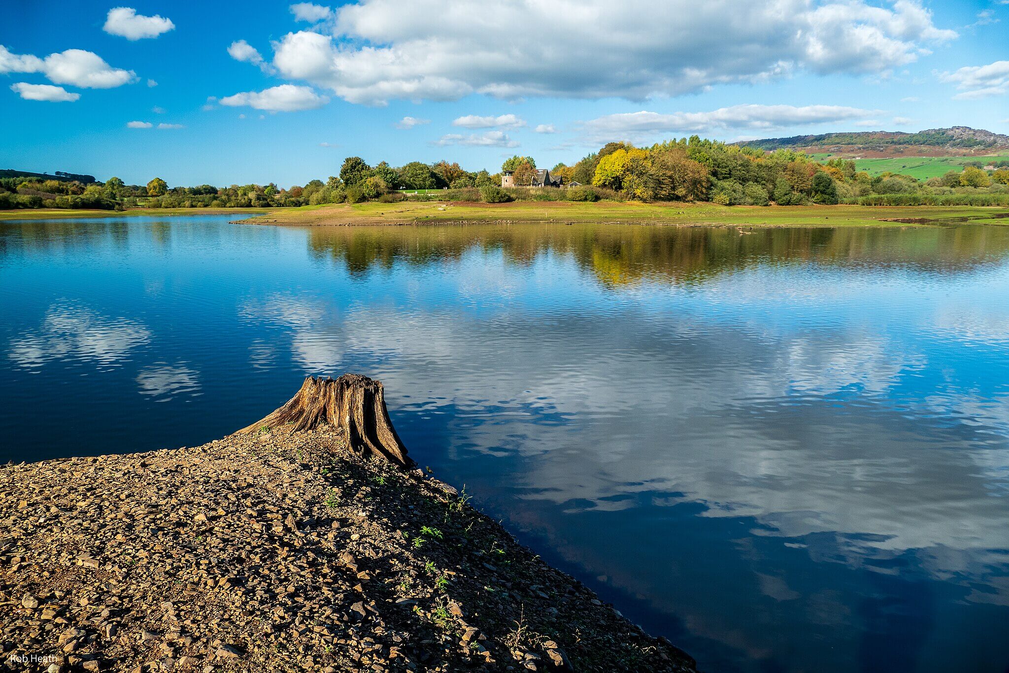 Tittesworth Reservoir – Photo Credit: Robert J Heath
Tittesworth Reservoir sits in the Staffordshire Moorlands just below the Roaches escarpment, fed by the River Churnet and managed by Severn Trent Water. This circular route starts from the visitor centre car park at the northern end of the reservoir and follows well-maintained paths clockwise around the water, passing through mixed woodland on the eastern bank and open meadow and farmland sections on the return. The walk crosses the dam wall at the southern end, climbs briefly through trees, then returns along farm tracks and a short stretch of quiet country lane with panoramic views back to the Roaches ridge. The circuit covers 7.5 km and takes around two hours at an easy pace, with two bird hides along the route for wildlife watching.
For dogs this is an accessible and genuinely enjoyable walk: the wide gravel and compacted earth paths are kind on paws in most conditions, and the scent of waterside reed, damp woodland floor, and the clean mineral freshness off the reservoir carries strongly throughout. Dogs must be kept on leads for the entire route, both as a Severn Trent Water requirement and to protect the abundant wildfowl along the shoreline. Blue-green algae can occasionally affect the reservoir in warm weather, so dogs should be kept out of the water on all visits. The River Churnet near the visitor centre provides a safe paddling alternative on most days, and the on-site cafe is dog-friendly at outdoor seating.
-
Distance: 7.5 km (4.7 miles)
-
Duration: 2 to 2.5 hrs
-
Difficulty: Easy
-
Elevation gain: 134 m
-
Walk Type: Reservoir, woodland
-
Route Type: Circular
-
Terrain: Wide gravel and compacted earth paths, some woodland sections and boardwalks; mostly flat with one short climb over the dam end
-
Off Lead Potential: Low
-
Livestock Potential: Low
-
Parking: Tittesworth Water Car Park, ST13 8SW. Pay and display; up to 2 hrs £3.50, up to 4 hrs £5.50, all day £7; cash and card accepted
-
Facilities: Watermark Restaurant and cafe at visitor centre; toilets; children’s playground; picnic benches
Tip: Keep your dog out of the reservoir itself as dogs aren’t allowed to swim, but there are shallow inlets nearby for paddling.
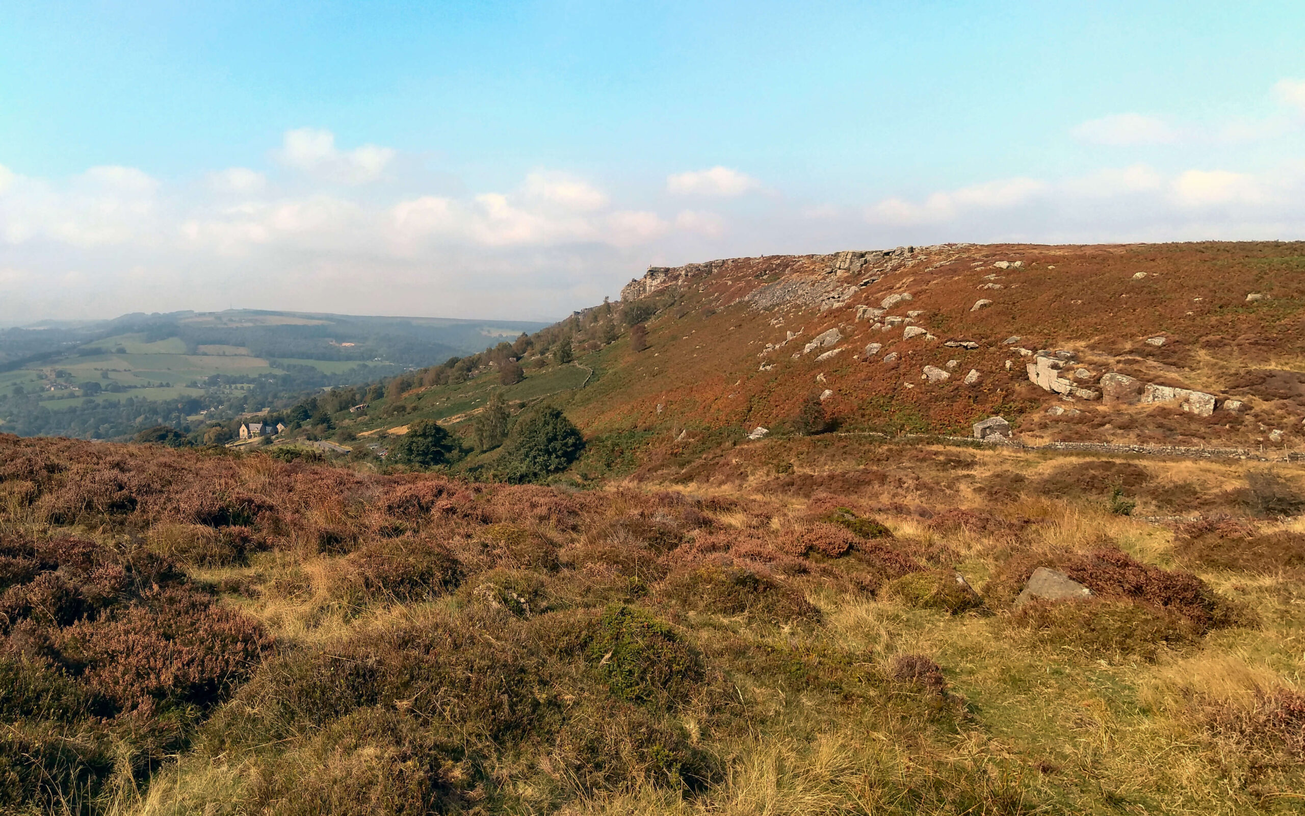
The Roaches and Lud’s Church
Rating: 9/10 — A gritstone ridge with jaw-dropping views, a woodland scramble into one of England’s most atmospheric natural formations, and a genuine sense of wildness that is rare this far south.
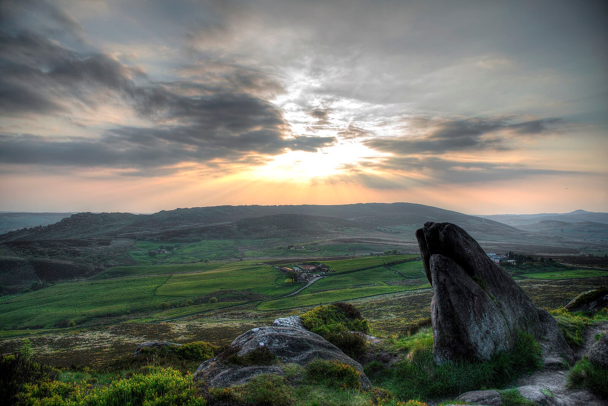 Photo: Simon Harrod, via Wikimedia Commons (CC0)
The Roaches is a distinctive gritstone escarpment on the western fringe of the Peak District in the Staffordshire Moorlands, rising to 505 metres above the surrounding farmland. This circular links the ridge walk with the extraordinary natural chasm of Lud’s Church, a 100-metre-long, 18-metre-deep fissure in the forest below, created by a massive ancient landslip in the millstone grit. The route follows Roach Road to the escarpment, climbs onto the ridge past Doxey Pool and the main rocky outcrops, then descends steeply into Back Forest and through the mossy green walls of Lud’s Church, returning via field paths to the starting point. The full circuit covers approximately 12 km and takes three and a half to four hours. Lud’s Church is steeped in folklore and is widely considered an inspiration for the Green Chapel in the 14th-century poem Sir Gawain and the Green Knight.
Dogs find this a richly rewarding walk: the ridge section offers open running on heather and gritstone with the sweet, resinous scent of bilberry and moorland grass carrying freely on most days, and the descent into Lud’s Church brings an entirely different set of sensory cues, the cold, dark air of the chasm thick with damp moss and ancient stone. Leads are required near the sheep grazing in fields at both ends of the route and on any brief road sections along Roach Road; the ridge and forest sections allow more freedom. Water is limited on the ridge, so carry your own; the River Dane runs near Gradbach at the forest end of the walk and provides a good drinking and paddling opportunity for those extending the circuit that way.
-
Distance: 12 km (7.5 miles)
-
Duration: 3.5 to 4 hrs
-
Difficulty: Moderate
-
Elevation gain: 479 m
-
Walk Type: Moorland, woodland
-
Route Type: Circular
-
Terrain: Roadside path on approach, rocky ridge and gritstone outcrops, steep descent into forest, woodland paths; muddy after rain near Lud’s Church
-
Off Lead Potential: Moderate
-
Livestock Potential: Moderate
-
Parking: Free roadside parking on Roach Road near Roach End, ST13 8TY; or Clough Head Lane layby, ST13 8UQ for a Lud’s Church-first approach. Fills quickly at weekends
-
Facilities: Roaches Tea Room at ST13 8TY; no toilets on route; occasional ice cream van on Roach Road at weekends
Dog-friendly tip: The climb is steep in parts and can be muddy after rain, so bring plenty of water and a towel for the journey home.
Map of Dog Friendly Walks and Hikes in the Peak District
- Mam Tor and the Great Ridge from Castleton
- Kinder Scout from Edale
- Padley Gorge and Longshaw Estate
- Stanage Edge from Hollin Bank
- Dovedale Stepping Stones Extended Loop
- Monsal Trail and Ashford in the Water
- Curbar and Froggart Edge
- Tittesworth Reservoir
- The Roaches and Lud’s Church
- Curbar Edge, Froggatt Edge and White Edge
- Dovedale Stepping Stones and Thorpe Cloud
- Mam Tor (Castleton)
Our map below shows the locations of each of these dog friendly hikes in the Peak District, browse the pins and click through to get directions.
Explore more dog friendly locations, including hikes, campsites and road trips on our Wildpack Map, our curated and ever growing map of locations to explore with your dog.
Tips for Walking with Dogs in the Peak District
Tips for Walking with Dogs in the Peak District
Weather on the plateau: Kinder Scout and the high moorland above Edale can experience fast-changing conditions including mist, rain, and strong wind regardless of the forecast at valley level. Carry a map, compass, and waterproof layers on any of the high routes even in summer.
Ground-nesting bird season (March to August): Many open moorland areas, including parts of Kinder Scout, the Eastern Moors, and Big Moor, support ground-nesting curlew, golden plover, and lapwing. Keep dogs under close control or on leads during this period, particularly in heather and rough grassland, where nests are easily disturbed and not always visible.
Livestock alerts throughout: The Peak District is working farmland. Sheep graze open access land on many of the fell and edge routes, and cattle are common on estate paths and valley walks. Always put leads on well before you reach any livestock, not when you arrive at them, to avoid panicking animals and the associated risks to your dog and the herd.
Water on the high routes: The Dark Peak plateau walks, including Kinder Scout and the edges, offer limited reliable water in dry summer months. Carry enough for the full day; dogs working hard on exposed moorland in warm weather need far more than most owners expect.
Dovedale and Chatsworth car parks: Both fill very early on sunny weekends and bank holidays. Arriving before 9 am is the reliable approach; arriving at midday on a Saturday in August is not. Both have paid parking that is managed, so there is no free alternative nearby.
Adder season (April to October): Adders are the UK’s only venomous snake and are present on heather moorland across the Peak District, including the Eastern Moors and the Roaches. They are rarely aggressive but will bite a dog that steps on them. Keep curious dogs from pushing their noses into low heather or bracken, especially on warm sunny days when adders bask on exposed ground.
What’s Nearby?
If you are keen to explore beyond the Peak District, there are plenty of other dog friendly adventures close by:
- Dog Friendly Campsites in The Peak District – Find dog friendly stays to have a base to explore all the Peak District has to offer.
- Dog friendly walks in Derbyshire – Reservoir loops, woodland trails and quieter countryside walks that sit just beyond the busiest Peak District routes.
- Dog friendly walks in the Yorkshire Dales – Big limestone scenery, wide valleys and classic hill walks further north.
- Dog friendly walks in Cheshire – Peaceful woodland trails and riverside paths to open countryside and sandstone ridges.
- Dog friendly walks in Staffordshire – Woodland valleys, open moorland and quiet country paths.
- Dog friendly walks in Shropshire – Rolling hills, quiet woodland and borderland paths that suit slower, more grounded days on foot.
- Dog friendly walks in Lancashire – Perfect for mixing coast and countryside, Lancashire combines fell walking, woodland trails and long reservoir circuits.
- Dog friendly walks in Lincolnshire – Ideal if you prefer big skies, steady paced routes and space for your dog to roam responsibly.
- Dog friendly walks in Leicestershire – ancient deer parks, canal towpaths and hilltop views across the quiet East Midlands countryside.
- Dog friendly walks in Nottinghamshire – from the legendary Major Oak to limestone caves and National Trust estates with proper off-lead freedom.